

psuhoffman
-
Posts
27,419 -
Joined
-
Last visited
Content Type
Profiles
Blogs
Forums
American Weather
Media Demo
Store
Gallery
Everything posted by psuhoffman
-
 Depends on whether there is a storm or not. It will be a lot warmer if it’s sunny than raining or snowing.
 -
We snowed with a -pna in the past. Not when it’s -4stdv you’re right. But why is it that when the pna goes negative it’s never -1 it’s -3 now? You’re beating around it.
-
Chuck even recently 75% of the globe is red. We just got lucky the tiny speck of cold was over us. But what about the rest of the time? How do we snow when we’re not lucky enough to have the rare cold anomaly over us when the rest of the globe is a hopeless torch of +anomalies too warm to us to snow. You said it. We don’t her marginal anymore. Because the whole planet is tiny pockets of cold surrounded by warmth.
-
You were sooooo close
-
You serious? Depends on the situation. For example I’ve been forced to advocate for positions I knew were weak and not clear winning arguments. What you do in those cases is very different. Then it becomes about minimizing damage. Attempting to deflect and exaggerate. But if you know the point you want to make is valid…1) focus on 2-3 points no more. 2) know how to articulate it clearly. 3) don’t let the other person deflect. When they try to take the debate off on a tangent redirect and reframe it back where you need it.
-
ok so why aren’t we getting marginal setups anymore!
-
Don’t
-
Yea but if heights are higher now, and the are, when the pacific configuration is hostile it’s more hostile. That’s my whole point. We don’t her marginal anymore. We get either good or hopeless which means the marginal part of our past snow climo is now missing. You’re so close but you’re twisting yourself into a pretzel to ignore the common threads tying this all together.
-
I know the answer. I’m asking YOU!
-
JFC I was starting to think I wasn’t articulating well enough.
-
That’s the period I am taking about Chuck. I said find me another period In the fucking past close to that level of warm anomaly
-
It’s like my points go right through you. It was cold because the whole other was perfect. I’m talking about when the pattern is not good. We torch anytime the pattern is bad because the pac is overwhelming now because heights are higher and so when there is a n pac ridge it’s not +100 it’s 400.
-
Ok then find me any 5 year period where the N pac averages +50m like 2020-2025. Fuck find me a period that was even +40. You can’t. Because it was never warm enough to get those kinds of heights before.
-
If we can’t snow without a EPO PNA ridge it’s a huge deal because a lot of our snow used to come withoit that. There was snow before 2017. And 2017 on has been our worst god damn snow period ever and your acting like that’s normal AND saying climate change is no big deal. You can’t have both of those takes they don’t coexist
-
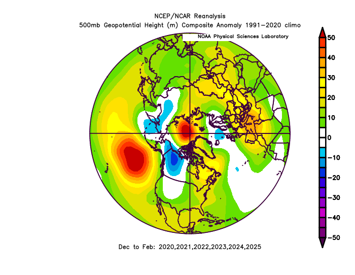
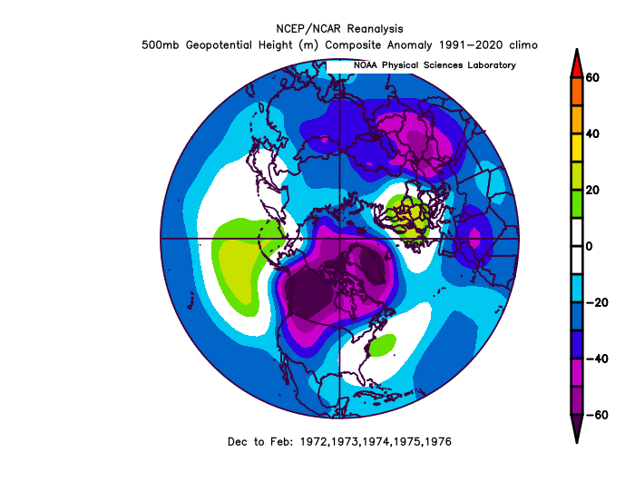
We’ve had this same confluence of crappy Atlantic and pacific before. The 1970s were an almost identical phenomenon. But look at these two anomaly plots. Why is now so much more red. Why Chuck?? It’s the same pattern so why is it warmer? has it occurred to you that the reason it’s snowing less is because when we get a crappy pattern it’s even more crappy now. About 40% of our snowfall used to come in flawed patterns. And those snows were barely food enough 50 years ago. We couldn’t afford what those 2 plots above show has happened! Yes we still snow when the pattern is good. But when it’s not good it’s hopeless now and you’re ignoring that. You’re pretending it’s always been this way. They getting snow requires the pattern to be perfect.
-
Thanks for answering a question I didn’t ask. But still waiting for you to answer why we keep seeing ridges that were unheard of in the past?
-
You just deflected right past my point and launched right back into yours. Ignoring the “why do we keep seeing ridges that were unheard of 50 years ago commonly now”
-
You’re still missing my point. We don’t get marginally bad pac patterns anymore because heights are increasing. Ridges are getting stronger. A +400dm ridge in the n pac was freaking unheard of 50 years ago and now it happens multiple times every year! When the pac goes bad it doesn’t go a little bad it goes to hell in a hand basket and overwhelms the pattern with warmth. But you’re acting like that is normal and not part of climate change. You’re not supposed to see a +400dm ridge this often. You can’t have it both ways. You can’t say this has nothing to do with climate change then act like something that was unheard of in the past is normal.
-
Luckily the EpS and GEPS are better
-
I don’t know. We’ve been in a bad pacific and Atlantic cycle simultaneously. Past examples of this were low snowfall periods too. But this one was about 20% worse! Do I think Baltimore ever gets back to averaging 23” over a 30 year period…no. But so o think our mean is really about 12” now? God I hope not. And I do think we could still see a cycle where we get a favorable PDO and nao and Baltimore could get a 10 year period it averages 20” But my bigger issue here is some of the people who are the biggest leaders of the “it’s not because of warming” band are also the ones acting like we need a fooking perfect pattern with a epo pna ridge and arctic air to get snow. Which ignores the reality of why was a huge part of our snow climo! They can’t have it both ways. They can’t say we can’t snow without a perfect pacific AND cry “climate change has nothing to do with it” because that would be a freaking change. We didn’t used to need the pacific to be perfect to get snow. Lately yes. But that’s why it’s sucked lately. And some of the same ppl saying this is just cyclical are also the ones saying “it dsnt possibly snow with a less than perfect pattern”. Ok if that true then it is climate change because it wasn’t that way and that’s a change.
-
Average highs might be too warm but what is the mean 850 and wet bulb temp? Again why do you act like we need a cold regime to snow. We have needed that recently but historically we got so many snowstorms in marginal thermal regimes if we get a good storm track. Do you know how many Baltimore snows were 45 the day before and after it snowed. We need those to return. Because cold regimes are often dry! A big part of our snow climo was from snowstorms in marginal temp regimes not cold ones. One of the reasons we are stuck in the worst snow drought EVER is that for the last 10 years or only snows when it’s cold. We need to get snow when the pattern isn’t perfect or Baltimore is going to continue to average half of what it’s long term 140 year average actually is.
-
Because we had a god damn perfect epo/pna pattern. Of course it can still get cold if everything is fucking perfect. We’re talking about losing snow along the margins. losing those snows we used to sneak in when the pattern wasn’t good.
-
Oh I agree but I stopped making this point because some agree and they get tired of hearing it because it’s depressing and the others won’t believe it and will cite examples of when it’s cold as evidence it’s not warming and it’a a waste of time arguing with them
-
ok jus saying you said you never seen it and I gave you an example. I’m not saying this is the most common thing or we want a +400 N pac ridge. Of course not. Just that we have snowed with this kind of setup before when there were extenuating circumstances to overcome the pac pattern


