psuhoffman
-
Posts
27,419 -
Joined
-
Last visited
Content Type
Profiles
Blogs
Forums
American Weather
Media Demo
Store
Gallery
Everything posted by psuhoffman
-

Winter Storm Threat *Technical* Discussion. No Op Run PBP or Snow maps
psuhoffman replied to CAPE's topic in Mid Atlantic
But you’re missing Grayhats analysts over in the other thread -
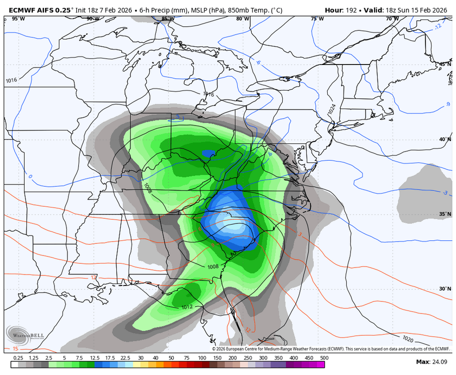
Dunno the euro stuff actually improved the Atlantic presentation leading into next weekend with a monster 50/50. GEFS went the other way. Mixed messages. AIFS just dropped pretty good run. Im Not saying I think a snowstorm is likely but I’ve seen this setup work. -pna with cold in front of an ejecting pac wave and a 50/50. It’s happened. Could end up warm. That’s definitely a threat. But I could see it work. That’s all I’m saying.
-
You aren’t super annoying. He is. We debate with you logically and with respect. Just because I sometimes argue with you doesn’t mean I don’t like or respect your analysis. He is just wrong. It might end up too warm for the storm next week but all he keeps doing is cherry picking the warmest op model each cycle and in most cases not even using the right time period. You make legit arguments. He is trolling.
-
stop gaslighting I saw multiple people give you constructive criticism over the last couple months and you just keep posting garbage. Which means it’s one of 2 things You’re trolling in which case you should be banned Or you’re just incapable of being better in which case you should stop and learn instead of posting all this crap Back in the early 2000s I was a lurker for years in various weather boards before I started to try to contribute
-
Ji is trying to mute you. Take a hint. when it’s everyone else…that means it’s you! Instead of blaming the criticism focus on being better.
-
OMFG this is legendary.
-
Winter Storm Threat *Technical* Discussion. No Op Run PBP or Snow maps
psuhoffman replied to CAPE's topic in Mid Atlantic
The main moving parts are the ridge over Quebec and 50/50 (strength of both) and the timing and strength of the pacific energy ejecting. EPS and AIFS had the most favorable look 12z of the options imo but it’s all still on the table until guidance settles on those features and as of now they’re bounding around every run. -
Thank you for answering the question “what if there was another Chuck, but who didn’t know anything and was even more annoyingly repetitive”. Im not sure who was asking that question but thanks for answering anyways.
-
The ai models aren’t meant for those details. Nothing is at this range frankly
-
No but thanks for trying
-
Deer sh!t covered. Mission accomplished
-
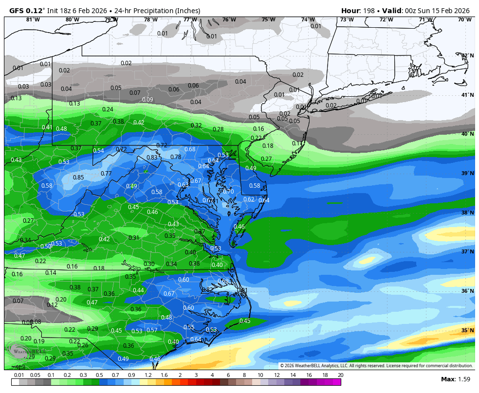
6-10” DC to PA line 3-6” south of DC another 40 miles
-
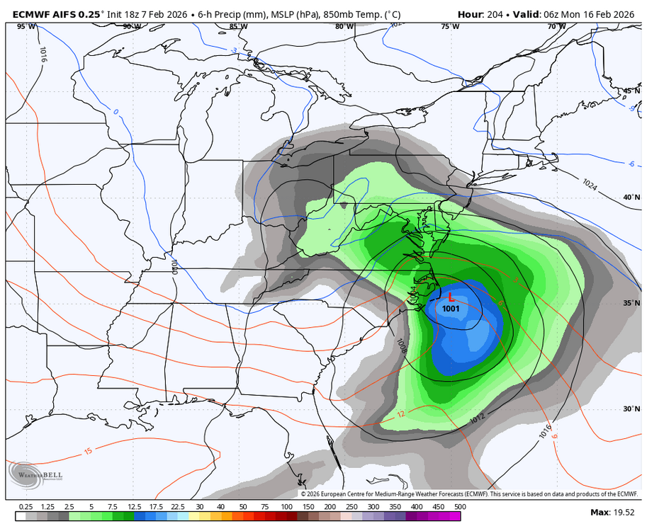
I also wasn’t accounting for the timing difference. I was seeing the 50/50 retreating sooner but not factoring the wave was coming faster this run. They evened out.
-
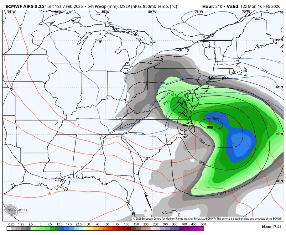
Never mind NS SW dives across the top and saves the day. What do I know. Horrific analysis. Randy so sorry. I’m out.
-
weaker 50/50 stronger wave probably means rain this run
-
You know…I was up in central PA during 2 previous winters with somewhat similar pattern and arctic cold and I was super dry for a month while down here was getting all the snow. The snow rides the boundary in thaw regimes and we ended up too far into the cold to get those cold boundary waves but not far enough north to get the pure arctic boundary waves. We have been in a dead zone.
-
You 150k people
-
26 light snow. Driveway caved
-
I’d be down with that. Remember the old classroom thread. That was a lot of fun because it was all legit stuff no clown maps
-
I know, honestly when I post the snow maps it’s because I’m lazy and don’t have time to do a full breakdown of the real maps or answer the 50 questions you get if you just post a promising h5 plot without any editing and analysis.
-
You have 9 friends and a mirror? also…”literally” …but I don’t make 150k so wtf do I know.

-
Don’t worry we know that window is yours. Brooklyn just does quick drive byes he don’t read up. He probably only saw posts about PD in the last hour and figured he’d enlighten us. It’s not quite as bad when it’s at least a red tag doing it. Some of the kids who post some model run 17 hours after it was discussed gets super annoying.
-
The flizzard has begun
-
I called someone a bigot today (for being a blatant bigot not political) and his response was “I’m not a FCKN bigot youse a fagot”