

psuhoffman
-
Posts
27,419 -
Joined
-
Last visited
Content Type
Profiles
Blogs
Forums
American Weather
Media Demo
Store
Gallery
Everything posted by psuhoffman
-
 3 of Baltimores 17 biggest snowstorms came in March. Baltimore has had snows of 22”, 16” and 13” in March. And 2 years ago I ran the numbers and showed that Baltimores odds of getting a 4”, 8” and 12” Storm peak the first week of February but then only decrease slightly until you get to the 3rd week of March when they drop off a cliff. You say this every year. Every single year. And one proven it’s false like 3 times and you still say it. Why?
 -
You give him an inch…
-
It’s gonna be the worst inch ever!
-
I hear you. But the last 2 ninos did you no good. My only point was assuming a Nino fixes this seems flawed. The issue hasn’t been enso.
-
That would depend on other factors. AO being the most important. Type of Nino. If we get a +AO east based +QBO winter we might be looking at a 1992 1995 type disaster but it’s too soon to know that yet. I’m not predicting doom and gloom. We have Chuck for that. I’m just saying don’t assume the rest of this winter is going to suck and don’t assume next year will be good.
-
But jokes aside why are you attributing our issues with enso. During the recent snow drought we’ve had 4 Nina’s. 3 neutrals and 2 ninos. And the snow results have been equally atrocious across them all for the most part. Arguably the closest we came to a good winter was 2021 which was a Nina but it was slightly too warm in DC. I got 50” here while 95 was getting 36 degree perfect track rainstorms all winter. But the issue wasn’t dry that winter! I don’t think enso had been our issue. Yes overall ninos are better and give us the best chance of a blockbuster winter. But it’s not as simple as Nino good everything else suck. We can have bad ninos and snowy Nina’s. The record -PDO the last 7 years was the bigger issue not enso.
-
It wasn’t the best period (unfavorable NAO and PDO combo) but not as bad as recent run! 1988 was solid. 1990 great first 1/3. 1993 and 1994 were really nice winters not far NW of 95. 96 of course then Jan 2000. It wasn’t quite the sustained dreg of the recent stretch. But ya far from glory days.
-
We are likely to have a +QBO next winter. The better ninos, 1987, 2003, 2010, 2015 were all -QBO. Not every +QBO was bad. We had some decent ones. 1988 and 2016 were ok +QBO ninos. But we’ve not had a blockbuster cold wall to wall +QBO Nino winter
-
The -AO is going to run the table. This has all the characteristics of a year with a wall to wall -AO. Do we cash in wrt snow…stay tuned but we have the snowier half of snow climo left to go! But of course we will have to listen to the insufferable jack asses who complain that the sun melts snow after Feb 10 so we should just toss the last 40% of our snow climo because it melts faster.
-
@Ji in my adult life we’ve had 4 unquestioned A+ snowfall winters. 2 of the 4 were ninos. In the last 20 years that I’ve lived up here I’ve had 8 winters that I’d classify as a A snowfall Winter, over 35”, and 3 of the 8 weren’t ninos and 2 were Nina’s. Yes all things considered I’d prefer a Nino. But it’s not as extreme as some are making it. People are using recency bias. But imo the pdo has been the issue not Nina.
-
You probably have more snow now than you had that whole winter. And 1992/1995/1998 were 3 dreg ninos in a row. Im not predicting anything but Im also not putting all my eggs into just waiting on Nino to save us
-
We had 1992, 1995 and 1998 back to back to back ninos remember prior to 2003 people thought Nino was bad for snow. 1973 and 1977 were lackluster snowfall ninos but 77 was for very different reasons. Ninos can be our absolute best winters but not all are good.
-
I’m saying I don’t know but only about half of ninos are snowy so kicking the whole rest is this winter when we have a -AO to wait for a Nino seems weird to me.
-
We entered that month with a torched North America so we have some advantages.
-
Sorry I was being a bit facetious. But we did have 2 ninos and 2 enso neutral winters in this 9 year snow drought we are in. None of them did us any good. The issue we’ve had is more PDO related than enso. At the moment the PDO has chilled out and isn’t killing us. We might fail. We could get a big storm. But I see signs we might be breaking out of what’s been the biggest issue the last 9 years.
-
It’s not a Nino. Pack it up. Better luck next year.
-
We have a cold enso. That’s not negotiable. I’m working within the reality we have. We’ve had snowy months in a cold enso before. It’s not impossible. And you holding out for a Nino is silly when we have no idea yet if it will even be a favorable type of Nino. And we know the QBO and solar are unlikely to be good. We could very well end up with a Nino like 1973, 1992, 1995, 1998, 2007, 2019, 2024. Not every Nino is above normal snow…only about half are and early indication are the next Nino might have more characteristics of the less snowy variety so now you’re waiting for what…the next Nino…4-5 years from now. Ok have fun. I’ll take my chances on getting a good snowstorm out of what’s a damn good pattern coming up. Yea it’s not a Nino. If it was it would be perfect. But you act like we can’t snow outside a Nino.
-
Feb 2006 and March 2018 prove if you have blocking the central pac isnt as important. The issue is it’s rare to get extreme blocking in that pacific pattern. Usually that pacific is destructive to blocking. But this year it doesn’t seem to matter. I’ll take the rare win.


-
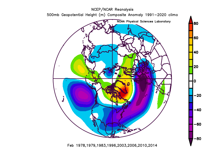
Just sayin Day 15 EPS snowiest February’s of the last 50 years and yes the pac is different because almost all those examples were ninos and a central pac ridge makes it unlikely to get blocking , that loading pattern actually correlates with a +AO. But we do have the blocking. What matters most is the N American long wave pattern is identical
-
Can we just start ignoring the op gfs? Especially at lead times we shouldn’t be looking at any operational frankly.
-
Charlotte is not getting 46” of snow. And I don’t care what the gfs says for 72 hours let alone 300.
-
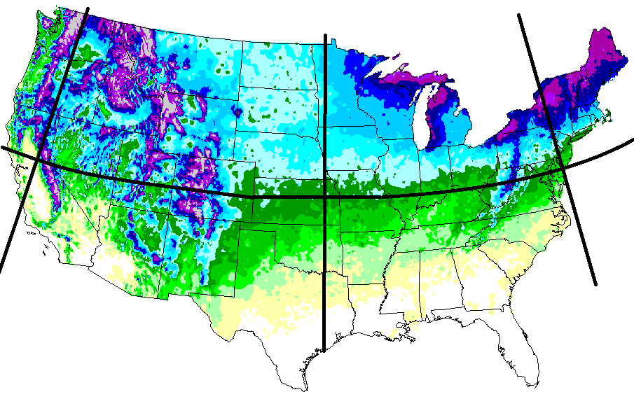
@mitchnick I saw this seasonal snowfall mean map back in the early 2000s and was like “what’s that little max in north central MD just south of PA that gets as much snow as southern CT according to this. That can’t be real”. So I started paying attention to coop reports in the area after every storm. Even drove up from northern VA a couple of times to see for myself. And damn it was real. During “snowy” periods there was this little area on these ridges up here that got dumped on. I remembered that when I ended up in the area and bought a place accordingly.
-
It’s been a rough few years for our area since 2021. But also, you’re in a bit of a dead zone compared to here. Over the 20 years I’ve been here I’ve done significantly better than Hanover. I got a lot more from that storm in December and the 2 day multiple wave event a couple weeks ago. Over the years I can even do significantly better than @HighStakes who is within walking distance but at the bottom of the ridge I’m on and sometimes that’s meant an extra 1-2” between us. The globals don’t have the resolution to depict it but when close to a storm look at the hrrr or 3k Nam. You’ll see the difference between the higher elevations and the valley Hanover is in. Hanover isn’t a bad spot and does much better than Baltimore obviously. But there is a bit of a regional snow max over the higher elevations area along and just south of the PA line in this area. Combination of location and the orientation of the ridges creates a meso scale snow max. I observed it for years before moving to the area. Snow isn’t the only reason I’m in the area but the exact location on this ridge was chosen when that in mind. I knew this exact spot was the snow max pretty much for this whole area.
-
I think even Chuck admitted a couple years ago that there is a difference between a full latitude trough causing a -pna and some STJ or mid latitude wave undercutting blocking.
-
You think it’s an accident I live here?


