-
Posts
26,411 -
Joined
-
Last visited
Content Type
Profiles
Blogs
Forums
American Weather
Media Demo
Store
Gallery
Everything posted by psuhoffman
-
It was tight
-
Are those the dangerous ones?
-
Tucked
-
Yea Vail owned mountains (epic pass) are a mess. People at Park City over new years weekend were hiking back up the mountain the lift line was so long. They under staff, didn’t use the pass $ to make upgrades the way Ikon mountains have, then started a labor fight with their workers for refusing some modest demands. They’re just a mess. Shame some great resorts being mismanaged. I love Breckenridge and Stowe but won’t ski them again until major changes happen. Then west south of Utah is also having a crappy snow year. Taos in NM has like 70” total right now. This makes the issue worse by limiting terrain they can open. I was thinking of a trip there but not this year. Just going to hit up VT and ME a couple times in March and April. I’m going to post a summary of my Revelstoke trip. Y’all need to get out there. Even non skiers it’s a snowmobile Mecca also but you ski it’s got to be a bucket list thing. I skied all week with no lines at all. Worst wait was 10 mins at the main lift on a powder morning. Most of the time no line at all. Snowed 14” while we were there and they had 250” before we got there.
-
Looks like a great spring New England ski season imo, for those who care, me. New England has been getting crushed lately and VT resorts are building a deep base now. And signs are for a reasonably chilly March not a sudden thaw. Once to April on sunny days it feels great no matter the pattern just some years they don’t have a ton of snow left to enjoy it. This year looks good for April ski season at Killington, Sugarbush and Sugarloaf. Stowe too but I don’t do Vail owned resorts anymore until they make some major management changes.
-
Weeklies extend our window until about March 10. It remains somewhat “chilly” after but it has a waves to our NW followed by cold shots look to me once past March 10. But this looks good Mar 1-8
-
No one even mentioned the euro gave us some Snow from a clipper on the 25 then was lining up another snow for March 1
-
lol It’s about potential. If we were in a Nino I might have a higher bar. But 8” has always been the bar of what I think feels like a big snow. But if it’s supposed to be a 20” storm and I get fringed with 8 that’s different so it just depends. But in general 8+ is a big snow, 4-7 is a moderate storm and 1-3 is minor and I generally meh those. But I can even enjoy a 1-3” event if it’s part of building a snowpack. Know you don’t care about that. But a 1-3” that’s gone a day later does nada for me. In every case meeting reasonable potential is more important than the number.
-
Spring is definitely coming. Not only does it feel warm out but the sun felt hot on my face walking to the car. Give me one legit 8”+ snowstorm and I’m ready.
-
I know there was a 16” snowstorm up here the first week of March 62. Must of been that storm.
-
Was that the Ashe Wed storm?
-
1996 was similar but that upper low was incredibly amplified and dove into KY/TN. We would need to see a major adjustment on that part for this to have that kind of potential.
-
My take, it was gonna be super close...I think anywhere east of 95 was gonna get crushed, full belt to a$$! for places NW of 95 it was close...the storm was about to go nuts but how fast...the CCB was going to have to get cranking real quick and bend more NNW then N or NE from where it ended which is not impossible, it happens in full capture scenarios but how fast it happens would be the key to places like where I am and you are. It would have to go full Jan 2000 or Feb 78 for it to work...but that run was about to be something close to that outcome honestly. The bigger issue is how likely is it to actually go nuclear not just on a model run, remmeber the UK has a tendancy to do that crazy over amp thing sometimes. It's teased us with some storms like this before...remember it had that one run of the coastal bomb in 2018 where it got a foot of snow back to Hagerstown.
-
To be clear I am NOT rooting for DC to get screwed...there is a path with a storm like this (unlike those progressive waves with their narrow west to east win zones) for the whole region to win...except Richmond F those guys. No seriously no ill will but unless we get some crazy Jan 2000 type full phase capture negative tilt tuck scenario its almost impossible to get a Richmond to the PA line win... But it is very possible to get a DC metro to PA line MECS result if the snow QPF max is centered near DC, places up here get higher ratios and oragraphic assistance and that's how you get a total win for almost everyone in here...again F richmond if they wanted snow they could move, kidding, unless they get snow and I don't and then not kidding.
-
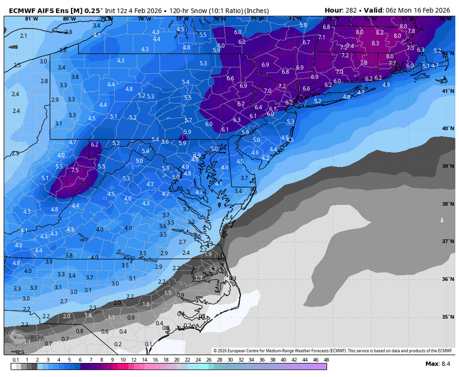
STRONG MECS signal... I'll take the 996 just off Cape Map please.
-
That's the trajectory I want to see...also the jack zone...When 95 is the jack heading into the final end game us northerners are usually fine...its when the jack zone is southeast of DC that we are in trouble. That right here is exactly where I want things at this range. Now just wish the GEFS would get on board...but I'd rather have the EPS if I can only have one of em.
-
BTW wanted to post what I've noticed over the years in terms of trajectory of storms on guidance and when they are most and least likely to adjust north v south. The angles are just symptoms on the models of the underlying reasons but since its easier to just see the angle of precip then to analyze those factors for most people its a cheat code kind of thing. The lines above represent the angle of the precip. Green is the angle most likely to adjust north. This is typical of a wave approaching from the SW, its mature enough to get precip up into the TN valley and its also gaining some amplitude as represented by the fact the precip is gaining latitude east of the mountains some. This combo is the most likely wave to adjust northwest. Guidance most often underestimates the northward extent of precip and the ability of the wave to push the thermal boundary north as it amplifies in this type of setup. Red is not a setup that often adjusts for the better if you are north of the precip and want that "north trend". Red often indicates a wave that is not amplifying, or not amplifying enough to offset a hostile cold press on the north of it. This trajectory is most likely to adjust south actually. Even in extreme examples like Feb 5 2010, it didn't hurt us, but that is an example that adjusted south some at the end...my friend in north central NJ was expecting 6-10" on the northern fringe and got 1". That storm, even as strong as it was, made absolutely no northern adjustment the final 48 hours and if anything adjusted south some at the last minute. The two waves this year that were fails for northern MD had this trajectory also. The two March 2014 storms both trended south some from 72 hours out and they were also examples of this trajectory. January 2019 was another example. This in my experience are least likely to trend north and are more likely to sink south some at the end. The Orange line is a problem because systems tend to adjust NORTH not WEST. A west trend actually requires a faster developing system and that actually goes against model bias that often phases and begins the amplification process of a late developing east coast storm too soon. 9/10 this trajectory will not end will if you are west of the precip on guidance 72 hours out...it probably won't adjust west significantly. There are exceptions to these 3 rules...nothing is 100%, wish it was that easy...Jan 2000 is a great example that broke the orange line rule. But these are generally when we can expect a north v a south trend MOST often based on the trajectory, which again is a cheat to factors causing that trajectory which make a north v south adjustement on guidance more or less likely.
-
I don't think we are worried about that area...I think those of us on the NW fringes of this region are the ones worried that it might do exactly that again. lol I'm not overly worried YET, but if in another day or two its still showing what it is now...
-
Most of MD just south or east of me didn't get much from that. There is a dead zone in northeast MD that's really bad this year WRT climo, worse then the typical "dead zones" I can remember in recent years. But we have a month of snow season left to correct that...I am kind of expecting something to come along to even it out some. Not necessarily totally even out, because places SE of us probably get some more snow also...but if we get one more storm and its like the GGEM or GFS show right now...that would be just crazy for a seasonal snowfall pattern. Might be the worse screw job NE MD has ever had honestly if it went down that way.
-
It's really only been 2 storms that jacked the same place...which isn't crazy for random chance. But a 3rd in a row? If we get 3 major storms this year and each has the exact same jack area...and its an unusual one at that given climo...that would be a first in my memory, maybe I'm forgetting a season that happened
-
name me one winter where every major storm jacked the same spot? I can't think of any! Even years where I felt I did worse WRT to climo than places to my SE there was at least more variance then this.
-
I would much rather nothing then that At least I wouldn't waste time tracking nothing...but if I waste a week tracking and that is the end result... like I said anything cute and furry better hide
-
I dunno but it's almost unprecedented for the lower eastern shore to get more snow than me, there have been some seasons like this where I only get a little more then them...but if we were to get one more storm this season and it jacks that area again and fringes us...it would be something that has NEVER happened before in terms of a seasonal outcome. It's getting beyond just "seasonal trend" into the freaky unprecendented getting 5 heads in a row kinda territory.
-
depends... but I doubt anyone in MD NW of 95 wants to see any model run that shows the snow SE of DC like that. Sorry but its kinda traumatic at this point. I would rather see a storm with precip type issues right now, both given this setup and given how this season has gone.
-
Every cute furry woodland creature better stay the F away from me if we get one more snowstorm with a jack SE of 95.