

psuhoffman
-
Posts
27,419 -
Joined
-
Last visited
Content Type
Profiles
Blogs
Forums
American Weather
Media Demo
Store
Gallery
Everything posted by psuhoffman
-
 I’ll buy that one please
 -
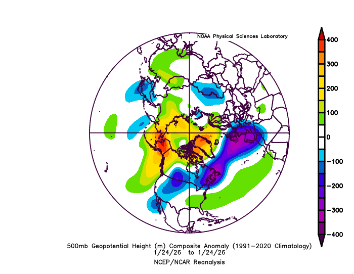
Btw I’m always trying to learn. My optimism for this weekend was a mistake because while the wave responsible for the threat did trend west so did the 50/50 and the whole TPV which caused the SW to dig to kingdom come and get stuck under the blocked flow. My mistake was adjusting one part of the equation without properly factoring in the other pieces that were likely to adjust also.
-
I like this look a lot We’ve had a favorable pna most of winter and it’s doing us no favors with precip. The one good qpf event we got was during a brief -pna. Ya it mixed but it phased super early and the block was kinda north and the 50/50 relaxed and there was a SE ridge am we still got a full region warning event! With the level of blocking we have I think we need some -pna. 2010 was a good example of how a -pna can be good if you had enough blocking.
-
The Jan 31 Potential: Stormtracker Failure or 'Tracker Trouncing
psuhoffman replied to stormtracker's topic in Mid Atlantic
WHen we are this close now... having the furthest east model come in line with consensus is not an "improvement" if the consensus is a miss. That is simply guidance converging on the solution...but in this case that solution is a miss. When a full run of guidance is over...average everything together...and if the average of all the guidance (and you should weight it, the euro gets more weight than the GFS in this math) but if the mean of the whole suite of runs didn't move closer...it wasn't an improvement just because one or two of the worst solutions got marginally better. -
The Jan 31 Potential: Stormtracker Failure or 'Tracker Trouncing
psuhoffman replied to stormtracker's topic in Mid Atlantic
@WeatherGeek2025 This is where the track would need to be for our area to get a big snowstorm -
The Jan 31 Potential: Stormtracker Failure or 'Tracker Trouncing
psuhoffman replied to stormtracker's topic in Mid Atlantic
Are you serious? Not a Fkn flake in DC from that unholy piece of excrement, just like not a flake from those storms in January 2017 and 2018. They gave the Delmarva snow...then NJ and NYC and Boston, we are further west, need a further west track. Frankly, the track we would need in DC with a storm starting out this far southeast, and especially anyone west of 95 in our area, we would almost need Boston and NYC to mix. See Jan 2000 for an example. -
The Jan 31 Potential: Stormtracker Failure or 'Tracker Trouncing
psuhoffman replied to stormtracker's topic in Mid Atlantic
I am not basing that off what any model is showing...historically a low position that far east of the Outer Banks of that strength would not have significant precip into DC. DC needs the low to be closer to over the outter banks tracking just east of VA beach...for me up here I want the low really tucked into the Delmarva to get a significant snow. A track that far off the coast is good for the Delmarva maybe...that is a similar track to those storms in 2018 and 2017 that gave OC a nice storm. -
The Jan 31 Potential: Stormtracker Failure or 'Tracker Trouncing
psuhoffman replied to stormtracker's topic in Mid Atlantic
That initial position off NC is likely too far east for 95 and points west, we need it just off VA beach. Good track for Ocean City though...it takes a northward enough trajectory to clobber NYC to Boston with that track also...yay for them -
The Jan 31 Potential: Stormtracker Failure or 'Tracker Trouncing
psuhoffman replied to stormtracker's topic in Mid Atlantic
One big issue is that as the NS wave responsible for all this has trended west so has the 50/50 and this is created a more suppressive flow over the top such that the more west track doesn't really matter...the wave is forced well south of us and cuts off then slides east before lifting because of the flow over the top being more suppressive, offsetting the better trajectory of the wave. -
The Jan 31 Potential: Stormtracker Failure or 'Tracker Trouncing
psuhoffman replied to stormtracker's topic in Mid Atlantic
So maybe my point is were are DUE! -
The Jan 31 Potential: Stormtracker Failure or 'Tracker Trouncing
psuhoffman replied to stormtracker's topic in Mid Atlantic
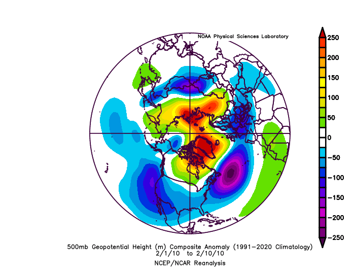
@MN Transplant you very well might be right about perception bias. However I’m not sure…I’m not talking about SWFE frontal waves. They most definitely do trend north. And we’ve benefitted from plenty of them including this last one. Yea it flipped to sleet but 6 days out most guidance was missing is completely and giving NC some huge snowstorm. However it’s been since 2000 that guidance showed a cutoff upper low to our south tha trended north significantly. I can think of a few examples where we were on the fringes and it eeked north just enough but I can’t think of a single example like this where it was cutoff down near Atlanta with a snow shown for NC 4-7 days out and it ended up hitting us. Now I know there haven’t been THAT many chances because that’s a pretty rare thing but there have been some. Meanwhile I can think of more than a handful of cutoff h5 lows projected perfectly for us at day 4-7 that ended up trending north and screwing is over to some extent. Now I know there were more opportunities but I can only think of a couple that were projected good at day 4-5 and stayed that way. March 2018 being one. So it seems going through the examples in my head the ones targeting us day 4-7 had a higher rate of trending north than ones targeting NC. It’s not that hard to go through all the examples of ones that stayed good in my head because frankly we’ve not had that many snowstorms lol. And most of the ones we did were SWFE open waves not cut off lows. It did seem NYC has had a lot more luck with storms that were supposed to jack us at day 4-5 than we’ve had with storms that were supposed to jack Raleigh to Richmond day 4-5. ETA: only examples I can think of where a cut off was projected good 100 hours out and ended up good the last 20 years was Feb 2010, Jan 2011, Jan 2016, March 2018 Out other big cutoff low snows didn’t lock in until too close to evaluate and didn’t trend north they were just waves that weren’t supposed to amplify until we got inside 100 hours. I can think of way more examples than 4 of upper lows that looked good 100 hours out and trended north. Hell one was 2 weeks ago. And it trended so far north the snow missed my friend in Vermont to the north! Meanwhile there have been about a dozen examples of a cutoff to our south in that time period and I can’t think of a single one that trended significantly north like that to help us. Actually more often they end up trended even more south and east and the storm even misses NC and ends up some weak wave way OTS -
The Jan 31 Potential: Stormtracker Failure or 'Tracker Trouncing
psuhoffman replied to stormtracker's topic in Mid Atlantic
When one snowmobile has way too much to drink and… -
The Jan 31 Potential: Stormtracker Failure or 'Tracker Trouncing
psuhoffman replied to stormtracker's topic in Mid Atlantic
Let’s ask AI how to deal with it -
The Jan 31 Potential: Stormtracker Failure or 'Tracker Trouncing
psuhoffman replied to stormtracker's topic in Mid Atlantic
That’s not totally true. We’ve got lucky in east based before with one big hit. But an east based Nino with an unfavorable solar/QBO would likely not be a wall to wall good winter like 2003 or 2010 and probably not even one that was mixed but features a very good 4-5 weeks like 1987 and 2015. But there is always the threat of one BIG hit even in a bad Nino because a juiced up STJ is sending waves at us and we just need to time cold up with one. -
The Jan 31 Potential: Stormtracker Failure or 'Tracker Trouncing
psuhoffman replied to stormtracker's topic in Mid Atlantic
Let me ask Gemini what it means -
The Jan 31 Potential: Stormtracker Failure or 'Tracker Trouncing
psuhoffman replied to stormtracker's topic in Mid Atlantic
And who are these people posting this crap? -
The Jan 31 Potential: Stormtracker Failure or 'Tracker Trouncing
psuhoffman replied to stormtracker's topic in Mid Atlantic
OMFG can we stop with the AI Chat BS -
The Jan 31 Potential: Stormtracker Failure or 'Tracker Trouncing
psuhoffman replied to stormtracker's topic in Mid Atlantic
The most obvious reason is the lack of STj which is Nina related. But why are there not even some reasonable decent northern stream waves? I don’t know. Honestly the pattern is suppressed so much right now we could even work with some NS only wave at times but even they are weak sauce -
The Jan 31 Potential: Stormtracker Failure or 'Tracker Trouncing
psuhoffman replied to stormtracker's topic in Mid Atlantic
Im not throwing in the towel on this year her. The pattern is very good in terms of being right for any amplification to be a snow threat. We just need something to happen. The last wave was a pretty good hit. This next one is so damn close but looks to be a miss. This pattern isn’t breaking down and is reloading actually. We have at least 3 more weeks and maybe more if guidance is right. We juts need 1-2 more hits. It can happen. After this we need a -AO Nino basically. What stacks the deck most would be to time up a west based Nino with a favorable solar and QBO. Problem is next year is likely to have unfavorable solar and QBO and early signs are east based. So… -
The Jan 31 Potential: Stormtracker Failure or 'Tracker Trouncing
psuhoffman replied to stormtracker's topic in Mid Atlantic
No our biggest issue next year is if it’s an east based Nino with a hostile QBO. Not all Ninos are snowy. Just the ones that are can be VERY snowy. -
The Jan 31 Potential: Stormtracker Failure or 'Tracker Trouncing
psuhoffman replied to stormtracker's topic in Mid Atlantic
I don’t think he is active on here, he lurks sometimes. -
The Jan 31 Potential: Stormtracker Failure or 'Tracker Trouncing
psuhoffman replied to stormtracker's topic in Mid Atlantic
Jokes aside it’s a good sign we’ve had 2 cold winters in a row. Our struggles turning that into a lot of snow has more to do with the lack of STJ because…Nina, than anything else and cold dry wingers were always a thing going back 100 years. So glass half full maybe we are out of the main issue that plagued us from 2017-2024 and we just haven’t had a snowy winter yet (and I’ve not given up on this one yet we just need one flush hit and the pattern is far from hopeless). -
The Jan 31 Potential: Stormtracker Failure or 'Tracker Trouncing
psuhoffman replied to stormtracker's topic in Mid Atlantic
I’m fine. I’ll be in Vermont at my friends, drunk off my arse this weekend BTW, he’s the smart one. He was a meteorology student with me at PSU. Big snow weenie. So he bought a snowmobile farm on top of a mountain in Vermont that averages about 150” of snow. -
The Jan 31 Potential: Stormtracker Failure or 'Tracker Trouncing
psuhoffman replied to stormtracker's topic in Mid Atlantic
And before anyone says “but it snows once in a while” yea it has to just enough to keep us engaged. If it never snowed at all we would have all either moved or moved on to other things in our lives by now. No no no, in order to inflict the absolute most pain and suffering possible they have to give us just enough hope to keep us coming back each time for the next kick in the nads. -
The Jan 31 Potential: Stormtracker Failure or 'Tracker Trouncing
psuhoffman replied to stormtracker's topic in Mid Atlantic
I’ve realized we are living in a simulation and the code was written by someone who was wronged by a mid Atlantic snow weenie and the whole point of the simulation is to get revenge


