psuhoffman
-
Posts
27,419 -
Joined
-
Last visited
Content Type
Profiles
Blogs
Forums
American Weather
Media Demo
Store
Gallery
Everything posted by psuhoffman
-
Because it has a cold bias??? Among many other problems lol
-
NOT WITH THAT TRACK ON FEB 15!!! Dude we had this damn debate a few days ago. Yea it was cold, when we had a perfect pacific epo pna ridge. Of course it was cold go back and look at the flow, air was coming straight out of the arctic cross polar and dumping into the Eastern US. And Utah was torching with highs in the 60s! We’ve had that kind of thing before and it was even COLDER! Look at 1977 and 1994! We’ve had high temps near 0 in past years with that kind of direct arctic discharge with snowcover. 30 years ago what we just had would have been even colder Chuck. And the globe didn’t suddenly get colder we were juts lucky to be under the tiny bit if cold real estate! look at the global heights from Jan 25-Feb 5. 70% is still RED Chuck. For the last time this isn’t about what happens when we are lucky enough to have a perfect pac pattern that dumps arctic air over us and we’re in the 30% of the world that’s blue. I know we can still snow them. But what happens the rest of the time??? What about the 70% when we’re under the red? When thickness are now 10-15m higher in the same pattern. You don’t think that makes a difference. You don’t think if the whole thicknesses were a little lower tomorrow or might not tip the scales from rain to snow for some places in this forum? Have you looked at the soundings tomorrow? The whole damn column is cold enough except the boundary where it’s 35-38 degrees. Guess what layer is warming fastest! The boundary. How can you possibly think it’s not making a difference with the marginal storms? So many of our past snows were barely cold enough because we’ve always been on the southern edge of where it snows much in winter. If you’re going to argue warming isn’t hurting us then you need to answer these 3 questions. 1) where did all the marginal snows during hostile pacific patterns go? Why don’t we get snows from perfect track waves during warm patterns anymore? Because we used to. I know. I have a data base of all of them. So what happened? why are perfect track waves doing hostile pac patterns juts perfect track rain now? What changed? 2) why has the median and mean snowfall for DC and Baltimore been declining consistently for 100 years and accelerating in the last 50. Explain it. Baltimore used to average almost 25” of snow and now it’s 19 and likely to fall closer to 16 when it updates next decade! Why? What happened to 30% of our snow? 3) since you’re saying warming isn’t hurting us in these marginal Situations then explain this. All the snowstorms we got during otherwise warm periods from a perfect track wave in the past when it was barely cold enough to snow…take early March 1962 for example. Some places just NW of 95 got 10” but with temps of 33-34 degrees while it was snowing. It just snowed hard enough to overcome the very marginal temps. But it’s warmer now. How would that still be snow if you apply today’s temps to that storm. Now it’s 35-36! The whole column is warmer too. Which is worse because it was probably isothermal so now it has 5000 feet of 35 to overcome instead of 33. How is that still a snowstorm? Or are you saying it’s not warmer? That thicknesses haven’t increased. That thermometers are broken and they’re all lying to us? because you can’t have it both ways. So much of our snow in the past came when it was barely cold enough to snow. So you cannot say it’s warmer but don’t worry that’s not hurting us. You can’t because if you warm is at all we lose so much of our past snow. 1-2 degrees F warmer and so many of those storms I documented get worse. Become 3” instead of 5”. A 3” wet slop becomes just rain! And suddenly it only snows during cold regimes and you say warming has nothing to do with it which makes absolutely no sense logically. How can you warm what was already a barely cold enough to snow equation and say it’s no big deal to our snowfall? Explain that Chuck.
-
 50s is normal in March. That won’t be a cold pattern but there is enough decent in other areas we could get a wave to track under us if it times up with a transient 50/50 feature. You only seem to pay attention to the pacific and ignore other factors. But we’re getting that this weekend and its rain so maybe we can’t snow anymore in hostile pac regimes and the last 10 years is just what is normal now.
 -
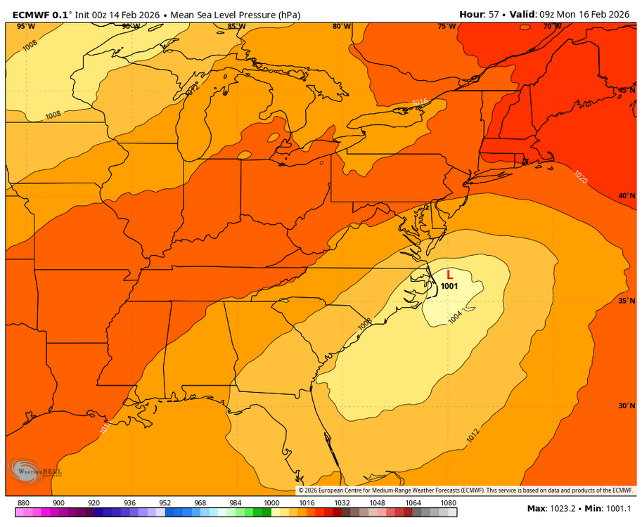
yup that’s a rainstorm on Feb 15th!
-
Guidance is converging on a perfect track rainstorm on pd weekend lol. perhaps another chapter in my book.
-
Winter Storm Threat *Technical* Discussion. No Op Run PBP or Snow maps
psuhoffman replied to CAPE's topic in Mid Atlantic
The h5 setup looks a little better (probably bc less spread at that range) than Feb 24 but my issue with the Feb 20 window is I don’t see enough cold in front of that wave. It’s going to try to ride the thermal boundary and it’s going to be hard to have it south of us given the ridge in front. The nao will force it to secondary but my guess is not in time because of the thermals. The Feb 24 has that going for it. There is a discharge (or could be) if cold behind the Feb 20 wave and if that 50/50 is the monster the euro guidance shows it could keep enough northerly flow into the northeast to have cold in place ahead of the next wave. We don’t have that for the 20th. They’re almost identical setups synoptically but I think the 24th one will have more cold to work with. -
I find this acceptable
-
SREF trended north lol
-
Winter Storm Threat *Technical* Discussion. No Op Run PBP or Snow maps
psuhoffman replied to CAPE's topic in Mid Atlantic
The setup for the Feb 24 window is this yea -pna but that’s about as good an Atlantic setup as we can get and later in the season is when this kind of thing can work. The cape wave merges with NS wave rotating around the TPV to form a nice 50/50 coupled with continued ridging in the southwest NAO domain! We would need timing but we get some cold air delivery behind the wave on the 20-21 and with that 50/50 developing it could hold off the SW flow for a few days creating a window of opportunity for something. With the crap pacific that’s what we’re looking for. Windows. We won’t have wall to wall cold in that look. But with the Atlantic and wpo we should get opportunities to time something up. -
Damn if I knew they served that... Can you order that delivery?
-
Can we get the seasonal trend here? Or do waves only trend south when we need them them to trend north??? Asking for a friend.
-
We say this every time then expect next time models will be better.
-
What do you recommend at starlight diner?
-
@Ji why is snow blue now? It used to be white...they used to make the map grey and snow was white on the maps...you know...LIKE THE COLOR IT ACTUALLY Fing IS!!! Who did this...I want names!
-
Winter Storm Threat *Technical* Discussion. No Op Run PBP or Snow maps
psuhoffman replied to CAPE's topic in Mid Atlantic
It's a legit window, AIFS loves it, even before it spit out that HECS just now it's been all over it tossing out various east coast snowstorm solutions there. Other guidance hints at it. The 50/50 from the CAPE storm...whatever that ends up being, is the key to our chances with the window around the 24th. -
AIFS has been really interested in Feb 24. I’m calling it the @Maestrobjwastorm
-
Just remember as we head into the final 1/3 of the snow season these helpful rules about what to expect when utilizing our guidance, just follow the chart If the GFS shows snow: It's not going to snow If the GGEM shows snow: It's not going to snow but you can raise one eyebrow If the Euro shows snow: It's not going to snow but you'll be tired from staying up until 1am If they all show snow: It's still not going to snow but it's going to hurt a lot more when it doesn't.
-
EVERYONE knows it's going to be warmer... but the PNA is the only thing unfavorable. The AO/NAO/WPO are all decent. And late Feb and March the PNA is not as significant as it is earlier in winter. We are trying to find opportunities to sneak a snowstorm in between the warm periods, which is very doable and has happened MANY times before in a -PNA late in the season. We almost did this weekend...if the wave was SLIGHTLY more amplified NW of 95 would be getting some snow Sunday in an otherwise warm period.
-
12z never updated, but.... I didn't see anyone post 6z which was pretty nice already lol. 12z op was improved so we can just assume 12z ENS are better right
-
AIFS ENS
- 589 replies
-
- 10
-

-

-

-

-

-
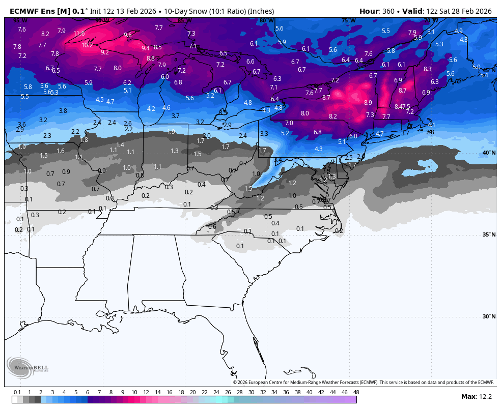
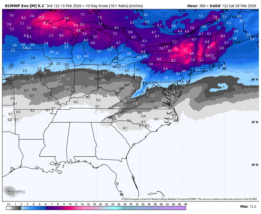
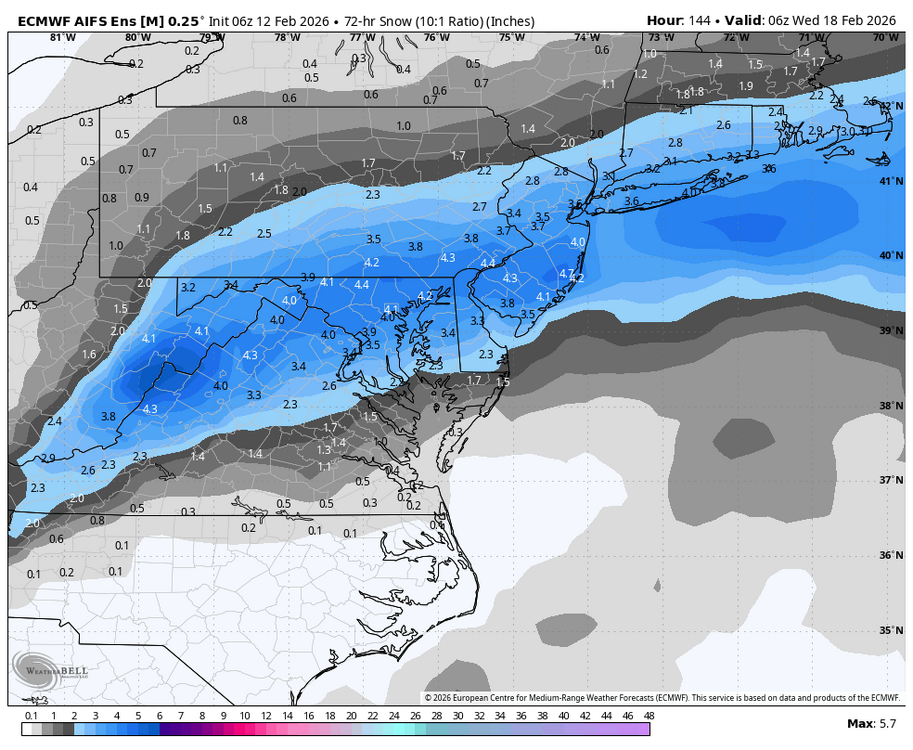
But that is the best median we've seen
-
It knows where I live
-
I said they like snow chases not grail quests
-
I need it to snow somewhere...I have the kids Sunday-Monday and they love snow chases.