

psuhoffman
-
Posts
27,421 -
Joined
-
Last visited
Content Type
Profiles
Blogs
Forums
American Weather
Media Demo
Store
Gallery
Everything posted by psuhoffman
-
I liked the end of the RGEM very much
-
I am not saying you are wrong...you're not... tendencies within patterns are a real thing. You're right. What I am saying is...it's not useful for predictive purposes because there are exceptions within those patters but most importantly you don't know when the pattern is going to flip. In 2005 we wouldn't have known the pattern was about to flip and go from a total torch to cold and snowy from Jan 20th on. Same in 2007. 2009 was dry all winter then we got that big snowstorm early March. 2015 flipped in February. 2016 flipped in January. 2018 flipped in March. 2019 flipped from good to bad in late January. 2022 was great in January and then flipped bad in Feb. It's pretty rare for a pattern to set in for the whole winter start to finish...sometimes a bad one does and we get 2020 and 2023. Sometimes a good one does and we get 1996/2003/2010/2014. But way way way more often the season is a mix and we get some snowy periods and some not snowy periods and end up somewhere between those few great years and few total dreg ones. And we don't know when the flips are about to happen until they do!
-
This was always a noisy setup with a lots of various SW's and phasing involved. Yesterday the timing and amplitude suddenly shifted with one of the waves and it changed everything. The euro was the closest all along to what everything else shifted to, with a stronger wave in the lakes on Friday/Saturday that stalls instead of lifting out. The timing of the weak STJ wave also changed and its running way out ahead on Saturday now, this is also influenced by the pinwheel in the lakes that wasn't there or nearly as strong on guidance until last night. But guidance is also trending towards a stronger inverted trough feature, also related to what's going on over the top of us. But those are really hard to pin down. With the trough hanging around and the upper low cutting off near us it wouldn't take much for this to come back if guidance identifies another SW to amplify. Most guidance just changed its mind with the wave that is now some weak POS on Saturday...it's not crazy if they find another little vort and say...ok lets amp this one up instead...the trough is there...the mid and upper level energy is there...it just needs something to come along at the right time to amplify at the surface. I want to see what happens today on guidance.
-
There are patterns within seasons for sure. But some of this is perception bias and selection bias. For example...your theory this year only works if you ignore the first real snow of the season that missed up just to the north in early December and gave parts of southern/central PA 3-6". Of course places further north would point to that snow in November in upstate NY but do we toss that because the winter pattern had not set in yet? Then yes...later in December those 2 events hit south of us...but I got 5" from a storm during that period also. Which one is the one that becomes the real pattern setter? It's easy in hindsight but that is biased. I am not denying your point about patterns within seasons. There are real tendencies for a seasonal pattern to produce repeating results. In a year like 1996 and 2010 that's great for us. Most years...not. But the issue is...this isn't very useful for predictive measures because of 2 things. 1) You don't know ahead of time when the pattern is starting. 2) You don't know during the pattern when it's going to end. Every pattern breaks at some point. Right now we don't know if that is going to be with this next storm (hopefully) or maybe March or maybe the pattern lasts into Spring and it's too late for us by the time it ends...but without knowing when it ends we can't just say every storm is going to do the same thing.
-
They were but...lol...euro totally missed the 14" we got the evening before...and then still was about .5 qpf too low for the second part. It was a pretty epic fail of the euro at very short lead
-
FWIW the evening before the Feb 9 2010 storm the Euro was showing about .65 qpf total for me. I got 32" of snow.
-
no snow for you...you come back one year
-
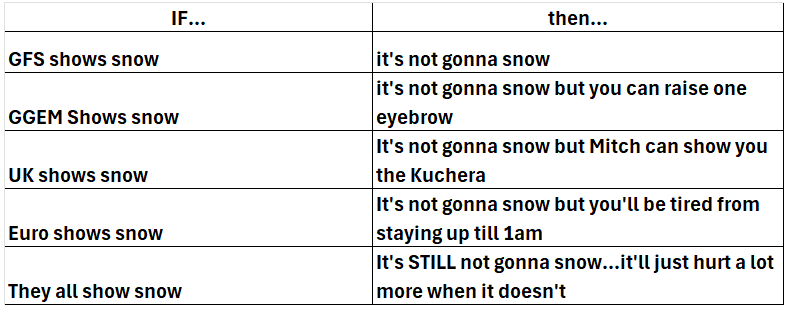
Consult the chart
-
yes
-
I posted some of our biggest snows and busts side by side once with the date removed and no one could tell them apart. March 2001 was one of the busts. The setup is often the same between a big hit and a bust and luck with minor factors tip things one way or the other.
-
March 58
-
in fairness this is a setup where I feel a LOT better here than around DC
-
@mitchnick @Ji @stormtracker a random thought about the AIFS and all guidance in general. Yes the AIFS will still bounce around at range with details. Exact track. Intensity. It’s not a miracle. It’s performing better than everything else. Take that fwiw. However, over the last 72 hours the thing it keeps bouncing back to is a hecs lol. It goes one way or another but it’s now spit out 5 hecs runs over 72 hours. This is the default it keeps coming back too. That’s important. It’s not some random fluke run. It’s shown up over and over. Doesn’t mean it’s the only solution. But it’s not a crazy outlier permutation it’s a real possibility or at least AIFS things so. In general this is true also. Maybe not hecs but secs/MECS the guidance bounces bit keeps coming back to snow! There was only one other time this winter when the preponderance of evidence was for a storm. Jan 25. All the others we were rooting for the long shot permutations not the most likely. Some were decent shots. 30% maybe 40% but none had a preponderance suggesting yes this is happening. Thats it. That’s the observation. Doesn’t mean we snow. I do think this is our best shot of the season other than Jan 25 from 5 days out.
-
Look at some of the -pna snowstorms in the 60s. It can happen. Especially if that 50/50 and Hudson high combo verify. But yea what could go wrong is more likely because snow is never the most likely outcome unless it’s that rare -NAO El Niño situation.
-
Only
-
Ask him why he thinks it’s going to be warm
-
@Stormchaserchuck1 you can’t claim every non snow scenario as your win. Of course not snowing is the most likely outcome. There are a ton of permutations and most end in no snow. But you can’t say “it won’t snow because the storm will be too warm, or suppressed, it just miss us, or over amped and track NE. Well duh. Ya likely one or those lol. You mean it’s not likely all the multitude of things we need to go right to get snow will all happen. Nostradamus over here.
-
@mitchnick. FWIW all The ensembles think the bigger risk is an over amped miss to our NW
-
Euro trend last 24 hours. If it did keep this up maybe another 2 more equivalent shifts and it would be a hit.
-
Op euro did move in the right direction the last 12 hours but it’s taking baby steps and we’re gonna need a bigger jump here at some point.
-
Let’s see what the eps says. 18z it was still suggesting the euro op wasn’t necessarily the most likely outcome. EPS beats the op at this range still. But this is complicated. And our luck has sucked lately. But I’ve liked this threat window for a week now. It’s legit. But complicated and requires phasing. We sometimes win with that though and we’re due. I keep saying that. When is this we’re due index supposed to kick in??? @Bob Chill
-
Yea icon trended to a stronger wave 1 and suppressed wave 2. AIFS went in between. Ggem went the other way at 0z. But across guidance the weaker that Friday thing is the stronger the Sunday storm and vice versa. Which makes sense. Conservation of energy in a limited space and all that jazz.
-
Euro is more amplified and slower with the Friday/Saturday wave. The result is its suppressing the flow behind it and absorbs what is the next wave on other guidance
-
Ggem just came around. I’d wait a run to assume it’s settled on a final idea. All the guidance right now still has a healthy enough primary that we get a good snowstorm of not the HECS places east of us would get. There is time to see it adjust either way. My bigger fear is the primary trends dryer and it becomes a pure miller b which would carry the threat of a real screw job up here.
-
Now if they did happen can it go in my book? That is a very valid concern and odds favor a miss to the east in a Nina but not EVERY time goes that way, so we can’t just assume. But yes my biggest fear would be a weaker primary with a late bombing tightly wound miller b that crushes east of us. That’s the hecs MO for Nina


