psuhoffman
-
Posts
27,419 -
Joined
-
Last visited
Content Type
Profiles
Blogs
Forums
American Weather
Media Demo
Store
Gallery
Everything posted by psuhoffman
-

Feb 22nd/23rd "There's no way..." Obs Thread
psuhoffman replied to Maestrobjwa's topic in Mid Atlantic
Was gonna say good news is temps look like the colder guidance right now. 32 at my house. Warmer guidance had me at 35-36 right now. -
He’s having a rough week. Let him have his cup of copium
-
Being upset and freaking out are not the same thing. People act like making a somewhat negative comment on here is being unhinged. We’ve seen some unhinged recently. Me saying I’m upset at missing a hecs by a narrow margin is just typical frustration. People do worse when a sports team they root for loses.
-
HECS opportunities are rare and I’ve missed the last 4 chances over the last 8 years by very narrow margins. I missed 20” snows by 20 miles twice to the NW and twice to the NE and yes I’m a little bent right now because I think the writing is on the wall that’s going to happen again tomorrow! I had hoped maybe with the trends we’d get the one last west tend needed but Im starting to get the sinking feeling the heavy snows end up just NE of me. And yes I’m upset about it I’m allowed to be I’m not gonna bunch furry animals like Bob but I’m upset ok
-
@CAPE for the last time I’m not saying we can’t get snow when everything goes perfect. If a deform crushed us with 2” qpf. But if I need marginal to work. Thats when we’re bleeding results away and you know that. Not sure why you think it’s funny. I don’t. It is what it is. But I don’t find it funny at all.
-
You joke but when my area gets results from a miller b it’s ratio dependent. I never out qpf places east of me but I’ve pulled off 15-20” from .75-1” qpf before. If I get 5” of slop from .7 qpf because it’s 33-34 degrees that is very much related to the issue you’re making fun of.
-
Here’s the thing, I need to decide whether to come home a day early. Here’s my bars. Less than 6” and I’ll be really really pissed I bothered to come home. 6-10 I’ll call it even. 10+ I’d be super pissed I didn’t come home. Help me make a decision lol.
-
I’m gonna NEED someone to promise me this isnt going to be another case where we spent a week tracking, got excited, convinced ourselves this might be different, then watch Philly get 20” while we get 3” of slop. I need that right now.
-
-
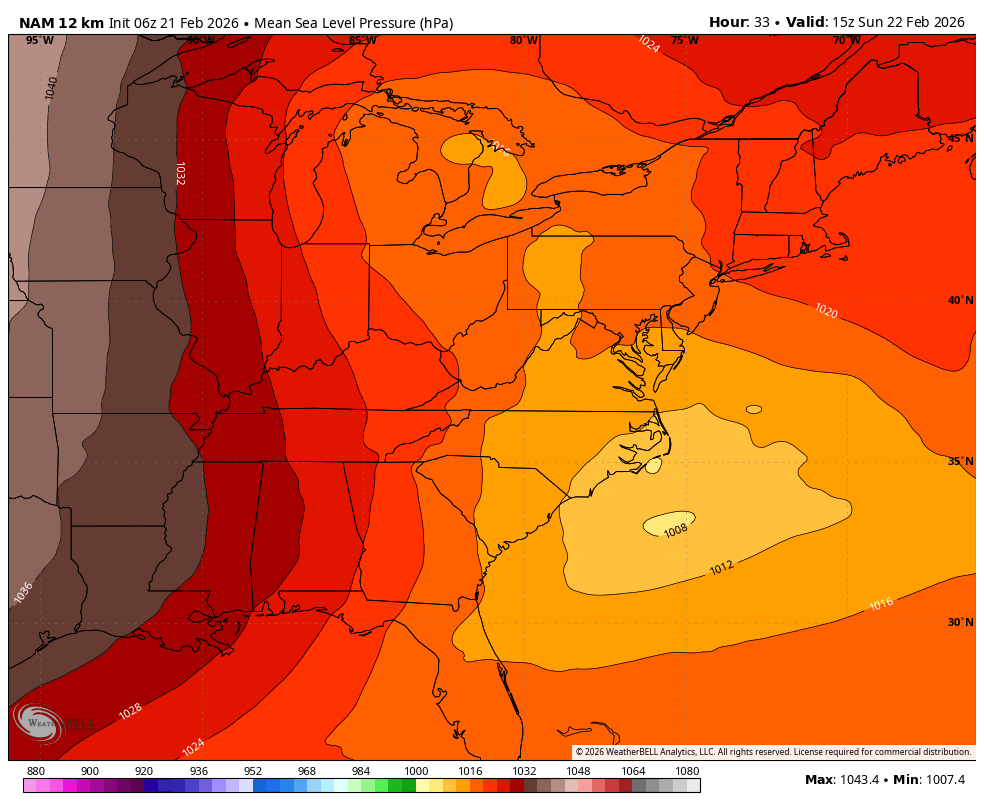
It’s super early but NAM is more negative and deeper right from the jump. Might be about to do a thing.
-
-
Pna?
-
SREF has been predicting the next run pretty well recently. 9z moved west

-
Feb 22nd/23rd "There's no way..." Storm Thread
psuhoffman replied to Maestrobjwa's topic in Mid Atlantic
Why are the Icon and rgem soooo warm! It’s Feb with a sub 990 low off the Delmarva and moderate precip. And it’s close to 40! WTF -
Feb 22nd/23rd "There's no way..." Storm Thread
psuhoffman replied to Maestrobjwa's topic in Mid Atlantic
@GreyHat can’t even blame me this time I laid off ya. But when it’s everyone else maybe it’s just you! -
Feb 22nd/23rd "There's no way..." Storm Thread
psuhoffman replied to Maestrobjwa's topic in Mid Atlantic
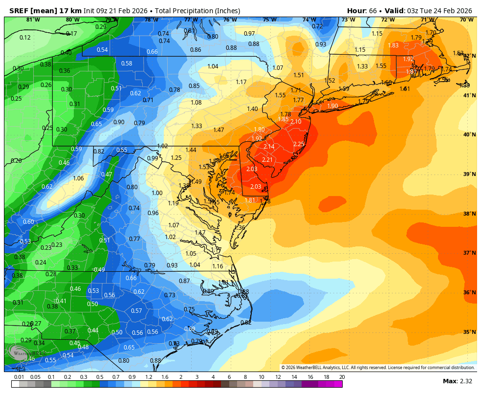
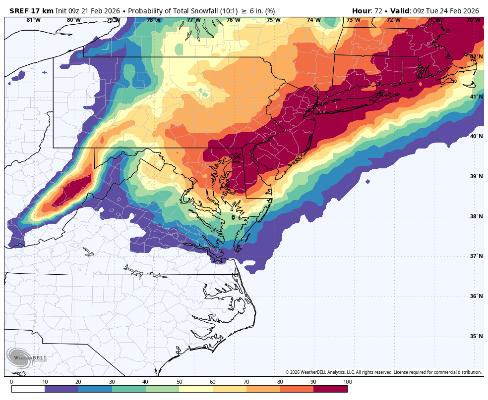
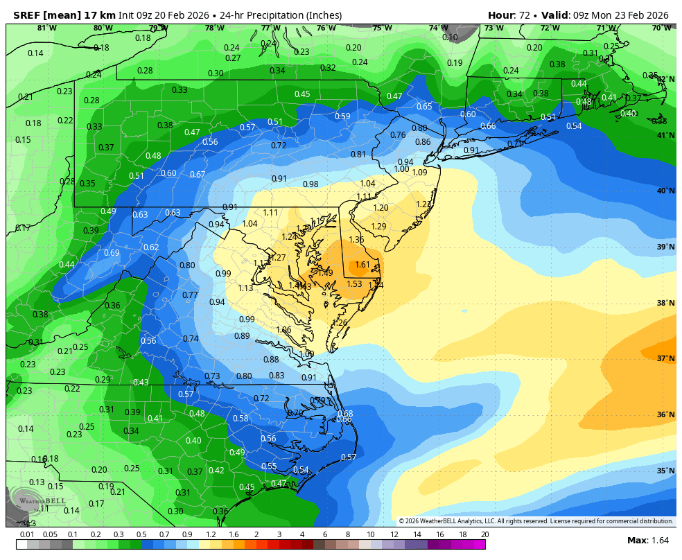
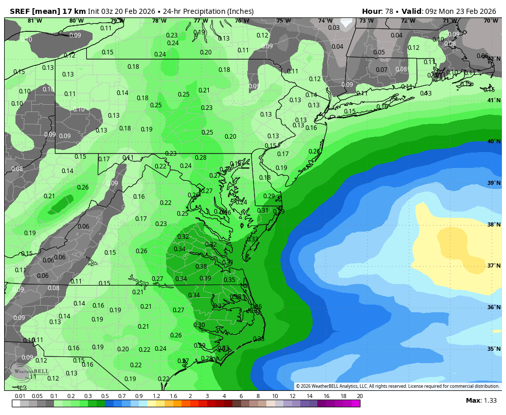
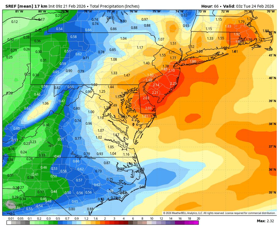
Sorry if it’s been posted but the SREF said folks this morning Went from this…. to this!

-
There is some truth to this (can't combine qpf and cold). Think about it...the EPO is the biggest tele for cold, but has absolutely not statistically significant correlation to significant snowstorms. Why? Because very cold patters are often dry! Think about how rare snowstorms are with temps below 20 degrees! I can remember all of them...because there aren't that many! Most of our snow comes near or just below freezing because historically our best snowfall patterns were split flow regimes where the northern stream was out the damn way but that also means no arctic air! A ton of our snow had to work with marginal home grown typical winter air not arctic air. If we are only cold enough to snow in true arctic airmasses we lose all those storms. We haven't lost them all yet...but we are losing quite a few which is why DC's average snowfall has gone from 25" to 14" in the last 100 years!
-
My Daughters name is Nora Lynn
-
Winter Storm Threat *Technical* Discussion. No Op Run PBP or Snow maps
psuhoffman replied to CAPE's topic in Mid Atlantic
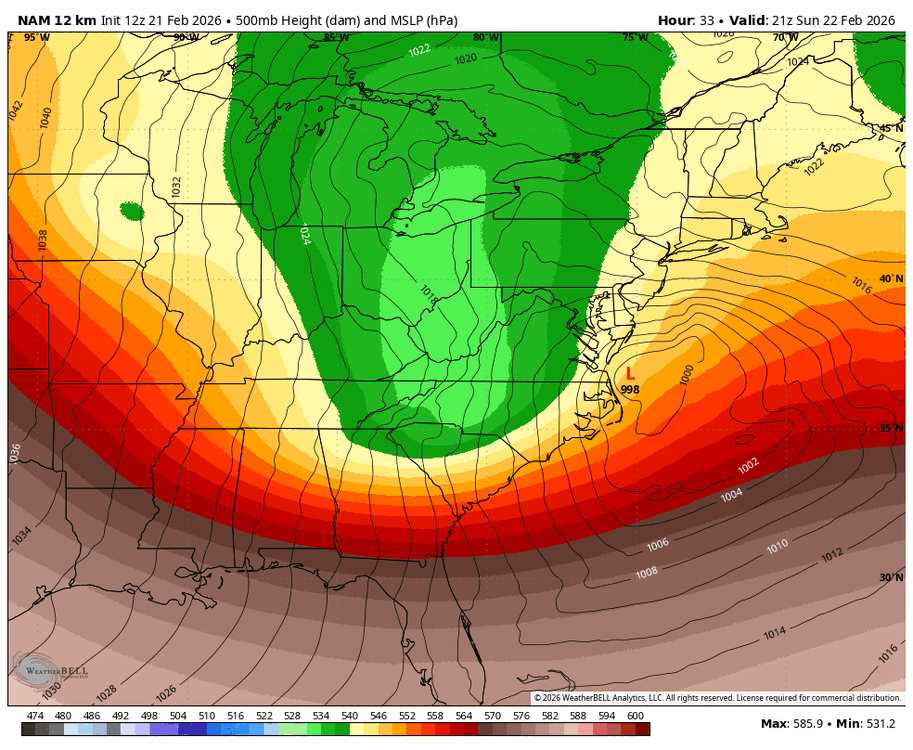
They had it for about 24 hours then lost it. It’s kinda a delicate balance. Everyone is just focused on snow maps and omg and model bashing but the phasing at about 24 hours is delicate balance between the two waves and just enough energy making it around the base makes the whole trough end up negative later on by putting enough energy out front to tilt the whole thing on its axis. But we’d normally never notice the relatively minor interplay of vort energy taking place if it wasn’t impacting a possible snowstorm. The result is hugely different but the cause is a relatively minor difference in handling how those 2 SWs interact within the trough early on. -
Feb 22nd/23rd "There's no way..." Storm Thread
psuhoffman replied to Maestrobjwa's topic in Mid Atlantic
Peace. Enjoy all the snow maps and “omg” posts -
Feb 22nd/23rd "There's no way..." Storm Thread
psuhoffman replied to Maestrobjwa's topic in Mid Atlantic
It reversed its trend on that this run and I’m very glad it did -
Feb 22nd/23rd "There's no way..." Storm Thread
psuhoffman replied to Maestrobjwa's topic in Mid Atlantic
There is only one model showing the coastal bombing and tucking and that (gfs) gives me 1.5 qpf. I’ll be just fine if that happens! But unless you’re in ocean city nothing else is even close with the CCB associated precip. Do I want the gfs to be right YES. But since that’s very unlikely, even now, I’m rooting for what is the better way more probable path to snow. The better trend on the other 18z guidance was enough to enhance the IVT with a close coastal but make no mistake without the IVT we are still always from all other guidance showing a hit from the actual miller b. We’d need another 2 shifts like the one we just for. Possible but rare I’ve seen the kind of amplification adjustment we need in the dozens of times we’ve been in this exact spot But that IVT can train moisture in off the developing coastal I’ve seen that happen way more often. -
Feb 22nd/23rd "There's no way..." Storm Thread
psuhoffman replied to Maestrobjwa's topic in Mid Atlantic
The IVT is responsible for 75% of that snow on the euro. It’s still our best chance of significant snow. If the coastal is closer it can help enhance that and it might seem like it’s part of the coastal but unless the gfs actually scores a coup nothing else shows our area (outside maybe the Delmarva) getting into the developing CCB snowfall from the miller b coastal. Even the much improved 18z euro all our snow is from the moisture training along the IVT. -
Feb 22nd/23rd "There's no way..." Storm Thread
psuhoffman replied to Maestrobjwa's topic in Mid Atlantic
The gfs came 10% towards the euro and the euro came 40% of the way to the GfS at 18z. Still a wide gap but not as crazy as before. Usually those compromise % are flipped