

psuhoffman
-
Posts
27,419 -
Joined
-
Last visited
Content Type
Profiles
Blogs
Forums
American Weather
Media Demo
Store
Gallery
Everything posted by psuhoffman
-
Yes but like most of the analogs it’s a dry cold. The snow mean is really low and look at the control which has similar temps lol basically has us sitting at the midpoint of winter below avg temps and under 1” of snow to show for it.
-
Agree with this... the -AO/NAO do still help, so long as we don't have some -3PNA countermanding it. The fact is we have had a horribly god awful pacific several times that did offset and waste a great NAO. Add in that two of our most recent snowy winters were EPO/PNA driven without much AO/NAO help and some have started to imply the NAO/AO are no longer that important. But I don't believe there is much evidence of that, it's just the NAO/AO can no longer overcome a horribly hostile pacific anymore.
-
I got 3.8" last December from exactly that type of setup. It's actually accounted for much of my snow the last 5 years...but most of them have not worked out for lower elevations. I commented on this last December also...the track of that secondary frontal wave was actually perfect for 95, the heavier precip missed me to the east, and the mid levels were cold enough, but as has been the case several times lately the lower levels simply weren't cold enough to support snow. This has happened a few times over the last several years. There was another very obvious example in Feb 2021, perfect secondary frontal wave where the lower levels simply were too warm despite a perfect track. I got 6" up here but that too the best precip missed me to the east but it was just rain because the boundary was just too warm...even up here it was 32-33 during the snow. We still get these setups often, it just hasn't been cold enough in the lower levels for them to be snow outside our higher elevations in this forum even when the situation works out from a synoptic setup in other ways.
-
These cycles are the main drivers of our snowfall...but unfortunately within these cycles there is a clear diminishing trend. The current bad cycle is worse than the previous one by about 20% and that good period in the 2000's was not as good as the previous time the Pacific and Atlantic both cooperated simultaneously in the 1960s. The most troubling aspect of that period from 2000-2016 was that the center of the positive snowfall anomalies shifted north several hundred miles from where it was in previous similar periods...we were barely above average snowfall for that period while places like Philly to Boston were running at 150% or more of avg. And not too far south of us actually were below avg for the period... In short while there are still these up and down cycles we are getting dangerously close to the "you're just too far south for it to matter" line
-
I agree with several of these points. WRT taking advantage of the Eagles injuries yesterday, Mitchell was only out for 2 plays and the Eagles blitzed and created pressure on both. I do not think this is a coincidence given that overall their blitz % is near the bottom of the league. They were covering for that issue and it worked. Who knows what the plan was had Lamar not been forced into a bad decision by pressure. As for the safety situation, the Eagles are pretty deep there, they have a young Safety who was starting last year who is now 4 deep in the depth chart due to signings and improvements at that position. I am not sure the drop off there is really all that great. I agree with all the other points though.
-
I'll be honest...my primary tracking interest when I first look at guidance any given run is for where I am going to be at a particular point in winter (Vermont next weekend, Revelstoke BC around New Years) not here.
-
I am shocked and confused (but interested and willing to listen with an open mind) by the perspective of Ravens fans here. As a neutral outsider (I neither particularly love but definitely do not hate the Ravens) I view them as a team with a good but not great roster that typically overperforms their talent level over the past 10 years. This year, they are about where the talent level says they should be. The talk about firing the coach is crazy to me. I did think maybe I was simply missing something and off on my evaluation so I looked at all the pre-season roster rankings I could find from the major publications like PFF, ESPN, Fox sports. I looked at 8 roster rankings in all and the Ravens were between 3 and 9 with an average of 6.5. I guess you could argue they are slightly under performing their talent this season since at the moment they have the 9th best record and by talent they should be 6 or 7 but that seems pretty minor, and I think they've had a harder schedule are are playing better in reality than a few of those teams with better records. I will admit I don't watch them closely enough and maybe this is due to boneheaded decisions that I just don't notice...but I didn't see anything in the game yesterday that he did that I found egregious or harmful to the team. They lost because the kicker missed a few important kicks but mostly because the Eagles defense did to them exactly what they've done to everyone all year and the Eagles offense ground them down late which is also what they've done to everyone all year. And the game ended about exactly how you would expect given the talent on both squads, the Eagles have the slightly better roster and they won a close game. What am I missing?
-
It’s 10 days away.
-
Bad solutions don’t lock in either. But the problem is we have a box about 100 miles wide (sometimes smaller depending on the setup) we need the storm to track. Anything outside that box is a fail. We don’t care or notice if it ends up 200 v 300 miles outside the box in either direction because the result is the same for us. No snow. The permutations that result in no snow exponentially outnumber those that do in any threat from range.
-
A 10% chance of snow is a better chance than we have most of the time lately
-
Ya well it’s hard to get “blue” even in a trough when the averages are calculated on a 30 year period that ended 5 years ago and it’s continuously getting warmer. The actual average base state right now in a neutral pattern is warmer than the averages those plots are calculated with. That’s one of the reasons why many times when you look at a long range plot there is no blue anywhere.
-
My one hope is that as we enter a warmer climate maybe the dry isn’t as dry and the cold is still cold enough. It’s a narrow target we’re aiming for though. But 2014 does prove it’s possible. But not the most likely outcome imo. I don’t find perfect track rainstorms funny but everyone has their own sense of humor. Ya 2017 and 1951 sucked but so did 2001 and 2009. None of them were good so not sure why you highlighted those 2 specifically.
-
There’s a trough in the east on that plot.
-
Some of my analogs are in there too. Problem is while they are cold most of them were not snowy years.
-
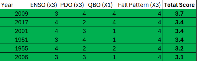
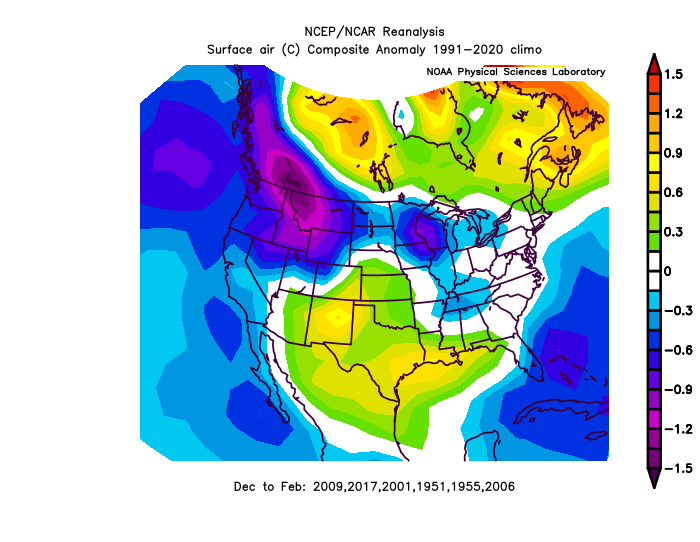
Top 5 were 2008-9, 2016-17, 2000-01, 1950-51, 1954-55
-
One of the limiting factors to this winter’s potential imo is there was a uniform characteristic across all my analogs, they started and ended cold. But the “snowiest” part of winter was the warmest in all of them! It’s really difficult for us to get a snowy winter without timing up a cold period somewhere between Jan 10-Feb 20 and that period was universally warm across all the analogs I identified. That leaves us nibbling on the edges so to speak. It could be worse. We’ve had several wall to wall torches recently. And there was some snow across our area in December in all the analogs so I do expect we get some snow soon…but it’s probably something small. This isn’t anything specific to the pattern (other than the fact it is NS dominant) just statistical probabilities.
-
No help
-
It takes special expertise when handling such a large bird.
-
Happy thanksgiving
-
It’s really hard to contain him when you don’t see him much.
-
This might seem political but I swear it’s really about why our method of argumentation and debate has become so dysfunctional. For a while now our political discourse has become unproductive because the debates tend to be proxies and not actually substantively about the actual issues motivating both sides. What’s the point even imo, to argue about these stupid side battles that often the person who starts it doesnt even care that much. Even if they lost the debate it wouldn’t change anything because the debate isn’t about anything substantive. But now I’ve noticed this bleeding into our science discourse. Todays spat in the long range thread being exhibit A. The hostility behind that had nothing to do with the exact strength of Siberian high pressure. If we’re going to fight and be hostile why can’t we at least just fight about what’s really aggravating people. Why are we fighting about ancillary substitutes all the time lately?
-
Snowiest week is the second week of December
-
Finally got my full winter forecast up, I did make some minor changes based on new information
-
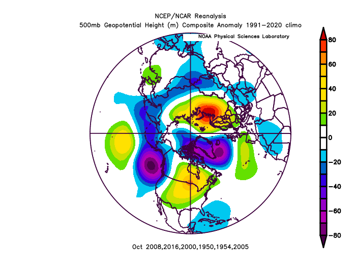
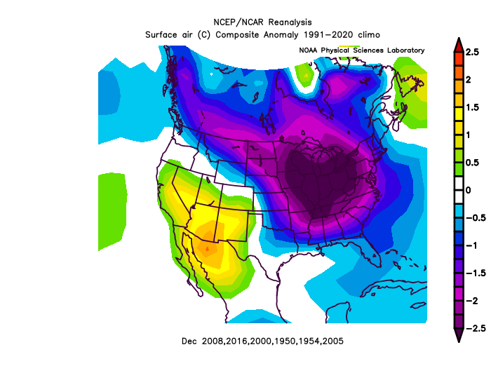
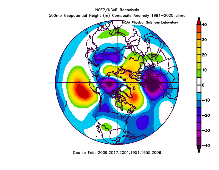
Sorry this is a little later than usual, I've been busy with some new responsibilities at work. I will also keep this generally brief as I think we all know the general ideas. Major factors PDO and ENSO: We are currently in a cold neutral enso state and expected to remain cold neutral or weak nina status. We are also still entrenched in a deeply negative PDO regime, coming off one of the most negative 3 month periods on record. However, the PDO does show signs if creeping back towards neutral although it is likely to remain solidly negative through winter based on historical analysis of where we are in the cycle. I don't think it really matters all that much if enso is cold neutral or weak nina, if it ends up -.3 or -.7 for the winter...when scouring all the analogs it really didn't make much difference. The flavor of all those -PDO cold enso winters was pretty similar regardless of the exact -enso strength. There are two types of cold enso years...ones that feature a more flat pacific ridge and they are generally warm snowless winters. Think 2002, 2008, 2012, and 2023. Then there are cold enso seasons with a more poleward pacific ridge which tend to be colder across eastern north america. Think 2006, 2009, 2011, 2014, 2018, 2022. The colder years do not always mean significantly more snow though as they are still generally dry and we are stuck between weak southern sliders and northern stream systems in the flow. But determining which flavor the enso will take will determine temps and the chance we have some snow and perhaps if lucky close to median snowfall. Fall Pattern: We were running a consistent -PNA driven pattern through early fall with a warm dry dome of high pressure over eastern N America. We have since transitioned into a -EPO -NAO pattern that shows signs of persisting in some form into and perhaps through December. Minor factors: QBO: We are currently in an extremely positive QBO phase expected to last through winter. This is not considered a major factor but it does make it less likely we see prolonged blocking through winter. Solar: We are still near a solar maximum expected to peak in 2025. However, I have found using solar to predict blocking to be dangerous as the correlation is fairly low and hard to predict if the episode of blocking correlated with the cycle will happen in any given year. Example: The most reliable trend I've been able to indicate is that we almost always get a year of extreme blocking near a solar minimum. It's happened the last 5 cycles. 1977, 1987, 1996, 2010, 2021. But sometimes the blocking comes right at the minimum, sometimes it was the year after the minimum. So even with this most reliable trend, its hard to use it as a reliable predictive tool as at best you have a 50/50 chance which doesn't help improve a seasonal forecasts chance of accuracy much. For this reason I did not weight solar this year in my analog rankings. I found when scoring my methods historically on what I would have predicted based on available data in the fall, I was better off not using solar at all. Methodological Changes I won't go into all the details but I've significantly increased the weighting of my PDO in analog selections. But more importantly, when scoring the PDO, our overall longer term phase of the PDO is as important as the most recent raw numerical number. Not all -1.7 PDO's are the same...there is a big difference between a short term negative drop in the PDO during a more neutral or even positive long term cycle...v the same number during a strongly negative PDO cycle. I've adjusted my scoring of the PDO to account for this. Forecast: We all know the negatives...the combination of enso and pdo that we are in is not good and we know this because we've been suffering through it for most of the last 8 years. So...probably the only question left is does this pattern flip that's just taken place change what the data is telling us about the coming winter.... Yes, but not as much as most of us would probably like. When I factored in some of the most recent pattern analysis into the equations, it did change the analog rankings some. And yes, some of the absolute worst analogs did drop out, but they weren't replaced by blockbuster winters by any means. There just aren't many of those in the weak cold enso, -PDO category. That combo is simply the absolute worst one for snow...and even if we pick out the best analog options from that combo...they just aren't very good. The one exception would be 2014, but its pretty far down on my analogs, that said with the new scoring, it was the next one tied with 2 others that just barely didn't make the cut. The fall pattern progression similarities helped bump it up some, but it still missed the cut. And the others that missed with it weren't nearly as good. Even if I included all 17 seasons I looked at when I started identifying analogs before eliminating many of them...NONE of them came even close to 2014 in terms of snow. It's simply an extreme outlier. Someday it will happen again but my guess is not in my lifetime. But who knows... What years did make the cut. Below is my analog rankings along with the weighting of the 4 point score for each category. So what about this upcoming great looking pattern...guess what all those analogs featured something similar... October was mostly a torch, November was a transitions...and December was very cold Fall-Early Winter Pattern for the top 6 analogs October Mean Pattern But look what it lead to in December....and around November 20 was the transition period also! Dec Temps Dec H5 Mean What about the rest of the winter.... well the pattern itself wasn't awful...on the whole they were near normal temps and all featured some cold periods. And they did all feature SOME snow...but the results in every single one was worse that you would expect given the way they started in December and the generally decent to good pattern mean for the winter as a whole. Winter H5 Winter Temps The general tone of all those winters was generally near normal temps overall but with several periods of true cold, but dry and not a lot of big snowstorms. Several of those years featured more snow south and north of us. Southern sliders missing south and northern stream storms missing north was a feature of all these years. Snowfall Forecast The raw predicted snowfall based on the analogs and weighting and my realistic snowfall range expectations DCA: 7.1" (5-10") BWI: 8.3" (6-12") IAD: 9.6" (7-13") RIC: 6.3" (4-9") Manchester: 24.7" (20-30") Northern Shenandoah Valley (10-18") NYC: 30.5" You can see that snowfall increases dramatically just north of us. While the changes in the calculations based on the current pattern did help us...it bumped up our expected snowfall a couple inches across the board and eliminated all the complete no snow dud years...it really helped places just north of us. It significantly increased the snowfall projections for Philly to Boston for example. We are just too far south to typically cash in on the northern stream dominant patterns even in the "colder" variety of nina, which I believe this will be. Temperature Forecast Overall near normal temps December Below Avg Temps January: Near normal temps Feb: Above normal Temps March: Below Normal Temps
-
I finally had a chance to finish my winter forecast and it adjusted my numbers just a slight bit DCA: 7.1" IAD: 9.6" BWI: 8.3" RIC: 6.3" SBY: 6.7"


