

uofmiami
-
Posts
1,637 -
Joined
-
Last visited
Content Type
Profiles
Blogs
Forums
American Weather
Media Demo
Store
Gallery
Posts posted by uofmiami
-
-
1 hour ago, SACRUS said:
A dry park could rack up a few 90s this week and next weeked.
Ill go 2-3 between 6/22 - 6/30 in the park and 4 or 5 in LGA/EWR.
I’ll take the under, as has been the case to date on 90 degree heat around NYC.
-
11 minutes ago, bluewave said:
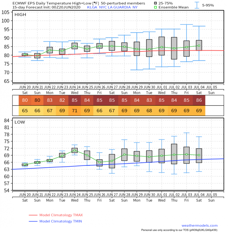
Looks like the highs will only be able to make it to around 90 next week in spots like EWR and LGA.This has been the the same theme since late May. The major 95+ heat has found a way to go north or south of us. Strongest ridging in the means has set up to our west. While this most recent ridge was able to build into New England, a cutoff was underneath keeping us in a more onshore flow. We may see a continuation of this pattern to start July. Models have another strong ridge to our west with another possible cutoff somewhere in the East.


Mid 80s for LGA on the Euro ensembles, going to be tough to see 90 it seems:
-
38 minutes ago, psv88 said:
84/69 here, forecast high is 78...
Your thermometer out in the sun? I have only gotten to 79 in Muttontown & Syosset both with VP2 FARS. Last I saw it was forecast to be 77 in Syosset.
-
33 minutes ago, Brian5671 said:
Bone dry here-lawns are brown. We've had about an inch of rain since 5/10.
I have my front yard zones, which are south facing & bake in sun all day, going on every evening around 6pm for 10 min each zone to keep the grass green. Started it a couple of weeks ago. Rest of grass is fine with water every other day in morning.
-
76/52 split in Syosset today. Muttontown was 77/49.
-
1 hour ago, psv88 said:
Eastern Canada in the upper 90s while we are 20 degrees cooler. What the hell
It’s the pattern. Called this Friday morning:
-
 4
4
-
-
5 minutes ago, SACRUS said:
Queue the Rascals - It's A Beautiful Morning, 79 / 55
0.24 in the bucket yesterday as the heaviest amounts stayed south towards Ocean country in NJ>
ULL looks to be going south similar to the May progression. Onshore flow on the go Sun - Thu next week. I do think with enough sun (despite the easterly flow) temps will over perform Mon Tue. But Wed and Thu may be cloudier and potential misty. Beyond there thing warm up by Friday (6/19) with Sat (6/20) - Tue (6/23) possible first heatwave potential as the big heat building in the plains and GL overspreads the Northeast. Way out there as we close June with an eye on Jul it looks overall warmer as WC ridging again pushes east into the Rockies / Plains...
I don't see the heatwave at all for next weekend, heat is getting muted now on Euro ensembles around NYC. Chris showed this as well. Montreal will probably get up into the 90s while we sit in the mid 80s down here. It's a struggle to get to 90 in NYC this year so far.
-
2
-
-
19 minutes ago, qg_omega said:
Better pool day? Saturday right?
Saturday looks better, especially from a temperature perspective. NBM has more clouds for Sunday & cooler.
-
.18" in Syosset & .15" in Muttontown, missed the heavier rains.
-
40.5 in Muttontown & 42.5 in Syosset this morning.
-
76.5 in Muttontown and 76.4 in Syosset for the high today.
-
34.5 in Muttontown & 36.3 in Syosset this morning for the low.
-
25 minutes ago, psv88 said:
Sun has been out here and its 70 degrees. This week won't be bad, time to turn on the sprinklers, as we need the rain
Yep I turned my sprinkler system on Friday, due to the heat and sun. Now with the forecast to be dry this week, definitely need those sprinkler systems on. Only have 1.04” for the month in the rain gauge to date.
-
44 minutes ago, SnoSki14 said:
Looks like we could see more onshore influence than we thought.
The big ridge is setting up much further west on GFS. Could be a fluke run.
Philly will roast & NYC will probably see a hot day and then get backdoored.
-
6 hours ago, stu said:
I just swapped the snowtires off my two vehicles. This was the first year they proved completely useless.
They are good for grip below 50. Summer tires that are cold when it’s cold out are like driving on ice. Going to take my winter tires off in the next week or so.
-
-
Looks like flakes were flying at 2am on security cameras. Got down to 32.5 this morning. Currently temp of 34 with windchill of 26, just crazy for May 9th.
-
Just now, LibertyBell said:
ABC mentioned that Trace of snow was reported in NYC on 5/29/95. What was the temp during it and why is it not remembered better? It was supposedly the latest snow at NYC. Was that JFK's latest too? I know their latest measurable was 1.5" on 4/19/83.
That was hail reported as snow. I think @uncle W or @donsutherland1posted the report was never corrected in the official observation.
-
3
-
-
-
52 minutes ago, uncle W said:
don't be surprised if the summer wasn't a scorcher... I'm thinking a normal to below normal summer with average to above average precipitation as of now...1919, 1946 and 1998 are the analogs so far...
@Wxoutlooksblogseems agree and thinks it won’t be a hot summer with this persistent NW flow pattern. Good for severe weather this year around here though.
-
30.8 in Syosset & 28.8 in Muttontown this morning.
-
17 minutes ago, LongBeachSurfFreak said:
Fully expect that tomorrow. 11/11/95 blew so much sand off the beaches and on the ocean parkway they used snow plows to plow the sand off the road. I’m looking forward to a drive tomorrow.
people are going to loose their minds if there are long term power outages from this. Luckily we are just before leaf outI'm sure a lot more people have generators now than pre-Sandy days, so the impact of power outages isn't as bad overall as it use to be.
-
3 hours ago, dWave said:
39 here, but good radiational cooling overnight elsewhere.
6am:
NYC 40, JFK 30, Teterboro 26, White Plains 27, Farmingdale 27, Morristown 19, Islip 26.
23 in Muttontown and 24 in Syosset this morning both occurring around 6:30 am. Currently 48 now and rising under sunny skies.
-
UK announced their upgrade now the US announces their upgrade:
-
 1
1
-


June 2020 General Discussions & Observations Thread
in New York City Metro
Posted
Going to be close. I'm 3 degree ahead of yesterday out here in Syosset & I got to 85.6 yesterday for the high.