

uofmiami
-
Posts
1,637 -
Joined
-
Last visited
Content Type
Profiles
Blogs
Forums
American Weather
Media Demo
Store
Gallery
Posts posted by uofmiami
-
-
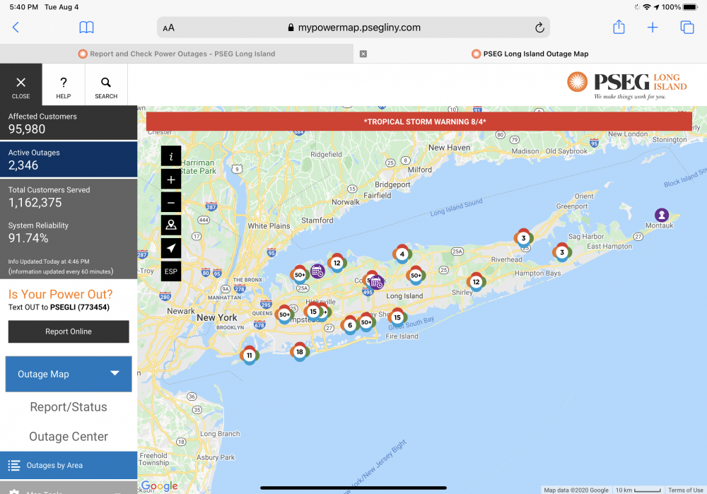
88 in Syosset. Muttontown offline at 6:27 am when internet went down.
-
26 minutes ago, psv88 said:
This makes no sense. FRG and ISP are mid-island. Stronybrook is on the north shore, so the winds traversed the entire island, and it still gusted to 75. North Babylon also nearly mid island. From Queens to Eastern Suffolk there was gusts 70+. JFK gusted to 70, FRG 78, ISP 69, Stonybrook 75. The entire island was trashed with 70+.
It's funny that you in New Jersey can opine as to the damage on long island. That's pretty rich.
Finally, your comment that only a few areas reported 70+ shows your complete ignorance of the island. There are very few official reporting sites west of the forks. All of them reported gusts 69+. There is zero support for your comment.
Further, EWR gusted to 68, and im sure areas in CT and the HV were similar.
Your point simply isn't supported by the data. Keep trying though, by all means.
We need more ASOS on the island. There are so many spots that lack properly sited anemometers, even many that have home weather stations do not go putting it up on a 6' tripod on their roof and grounding it, so that it's 30 foot. I have my two for the NE Nassau, haha. Those were 54 & 49 FWIW as highest gusts. Driving in to Great Neck and taking Northern Blvd, you can see the area overall had gusts up to 80 mph. I'm sure W Suffolk did without a doubt as well.
-
 1
1
-
-
Power was restored at my office in Great Neck Plaza, went off at 2pm.
-
-
-
Wonder if the numbers go up some more as they get more reports in.
-
4 minutes ago, jm1220 said:
There’s never much rain on the east side of these at this latitude. You have to be lucky with whatever feeder bands there are.
I know that but I still figured we’d get close to 1” but that never even happened. Glad I left sprinkler system on this morning to run.
-
3 minutes ago, jm1220 said:
I think even Fay had more rain here. The feeder band was spotty in this area and obviously any steady rain was west of the city.
I think Fay did as well. As you said just the nature of the feeder bands by us.
-
2 minutes ago, SnowGoose69 said:
I think the majority of the strongest winds were in a corridor of Nassau to West Suffolk. It seems less outages and damage occurred near the Queens/Nassau border and east of FRG
Lots of trees down in Great Neck. Also PT/Wx in Douglaston said trees down on parked cars by him.
-
15 minutes ago, Rjay said:
I never thought there would be much on the east side. Models did a good job.
Didn’t most have on average .50 for coast? I only have .13 here in Syosset & .25 in Muttontown for storm.
-
1
-
-
46 minutes ago, tiger_deF said:
Now that Isaias is moving out would you all say this busted under, over, or roughly as predicted?
As predicted. 60-80 mph gusts happened on LI and the damage/outages is what one would expect. If anything busted it was precip on the East side of storm.
-
3 hours ago, dWave said:
Im guessing no, highest I saw was 88 and now latest update is 86.
Yep, 88 was the high for NYC.
-
31 minutes ago, Rjay said:
That flight doesnt seem likely
Surprised it wasn't cancelled already, it will be later tonight most likely.
-
13 minutes ago, SACRUS said:
EWR also hit 91 in between hours.Not sure of NYC
I would think NYC hit 90, but never know. I hit 90 at my two weather stations (Muttontown & Syosset) & they usually run about the same at NYC if not a tad cooler.
-
1
-
-
Just now, psv88 said:
Getting a bit concerned out this way now, not liking those high wind forecasts at all.
You got a generator? If not, I'd be worried about prolonged power outage. Good test for PSEG infrastructure projects they've been doing for years since Sandy.
-
28 minutes ago, Rtd208 said:
Mt.Holly (KDIX) radar down again?
Wtf is a wideband issue? Never heard that one before.
Aug 01 2020 18:50:43
KDIX has a Wideband issue. Techs will be looking at it shortly.
-
Looks like NYC hit 90 today, heatwave continues....
-
-
74 for low in Muttontown & 75 in Syosset. Already 81 in Syosset & 80 in Muttontown currently.
-
Ended up hitting 95 at both stations for the high. 94.6 in Muttontown & 94.8 in Syosset, hottest temps to date this summer at both.
-
22 minutes ago, psv88 said:
interesting that your stations are always so much cooler than even the ASOS sites further S and E. You have lots of woods nearby? Elevation?
My house in Syosset is around 220 ft in elevation. My parent's house in Muttontown, 154 ft elevation, has a preserve easement along their backyard, along with the area just being zoned for large lots.
-
1
-
-
94.2 is my high so far at both my weather station locations, Syosset & Muttontown.
-
87 in Syosset & Muttontown currently.
-
9 minutes ago, psv88 said:
The only benefit is the strip of clouds among the seabreeze front. Temp dropped 3 degrees but dew jumped by 6...
Yeah I’ll take the clouds but not the DP jump. You can enjoy that


August 2020 General Discussions & Observations Thread
in New York City Metro
Posted