

uofmiami
-
Posts
1,637 -
Joined
-
Last visited
Content Type
Profiles
Blogs
Forums
American Weather
Media Demo
Store
Gallery
Posts posted by uofmiami
-
-
57 minutes ago, Rtd208 said:
The 06z NAM/GFS is much wetter for Friday/Saturday. Not sure what the Euro showed.
Around 1-2” it seems, locally higher spots, then hot for next week.


-
 1
1
-
-
28 minutes ago, gravitylover said:
Oh, haha. Long day on the road yesterday, I should have looked before speaking :blush:
No worries, I figured you didn't know about the tropical potential, so I just put the map up.
-
1 hour ago, gravitylover said:
FAY? What's that?
Next tropical storm to be named in the Atlantic.

-
2
-
-
17 minutes ago, bluewave said:
It will be interesting to see if that cutoff low later next week can take on some tropical characteristics. We haven’t missed an opportunity for onshore flow since May.

There goes another potential heatwave, never fails with onshore flow this summer.
-
7 minutes ago, SACRUS said:
Full sun now with clouds over NW NJ. Should be about an hour to heat up more before next mass of clouds moves in around 1 for an hour or so.
Looks like EWR, LGA & JFK all hit 90 already.
-
2 minutes ago, SACRUS said:
81/65 with mostly cloudy skies. Some of the clouds are breaking up and burning off a bit and should shoot temps into the 90s. With enough sun ahead of storms later this afternoon and early evening, it should push temps to or beyond yesterdays maxes.
Cooler flow for the 4th of July and Sun, will produce gorgeous weather both days mid upper 80s, cooler california like beach weather. Heat returns next week Mon - Fri. Need to watch cut off setting up over the Carolinas by Wed PM/ Thu otherwise the heat is on and looks to continue beyond into next weekend 7/10-12.

Your satellite loop is showing yesterday. I’m thinking these clouds are going to keep a lid on temps with the backdoor front clouds racing in from the NE as well.
Also, looks like heat for next week is legit with a potential shot at our first heatwave for NYC region.
-
Clouds are coming in from the N now & might thwart a run at 90. We shall see.
-
2 hours ago, Stormlover74 said:
.thumb.png.b519ab913fa5d91ac849c90bdd5bb1e4.png)
Is my cache on my browser messed up or is this a map from June 27th?
-
1 hour ago, LibertyBell said:
didnt happen at JFK, I wonder why?
JFK hit 90 @ 1:30 pm today.
-
1
-
-
6 minutes ago, dWave said:
Not a cloud in the sky, 83 dew 66.
On track for NWS forecast of 90
As long as skies are clear 90 seems a go for today. Tomorrow we’ll have to see if clouds pop up and thwart another attempt at 90.
-
40 minutes ago, psv88 said:
Storms weaken on the north shore and blow up on the south shore. Weird
Probably where seabreeze front is, since the clouds have limited our heating and the movement of the seabreeze front northward.
-
1
-
-
16 minutes ago, SACRUS said:
81/63 and a bit drier then the past 2 days. Currently mostly sunny but clouds building down from the north. Overall anther warm day that may see the sunnier spots bet guidance and nab a 90 degree reading. Trough builds down and cuts off over the northeast creating unsettled weather Tue (6/30) - Thu (7/2). More N / NE flow component this week with Wed and Thu looking to be mainly cloudy and could see widespread showers.
The trough / ULL is pushing out by Fri and the winds go more W/NW pushing the heat into the region. July 4th should start warm then see more of a NE cooler flow push in for the evening which continues Sunday. Warmer flow kicks of a hot week by Mon 7/6 (coastal/beach areas by Tue 7/7). Off to the races 7/6 and beyond with chance at strong heat and seasons first widespread heatwave.
Have a hunch in a few days, Wed-Thu, the guidance will mute the heat in the extended. It’s been the pattern this summer so far & until the heat is within a few days on the models, I’m not biting on a heatwave.
-
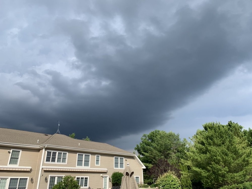
I’ll add my photos from Muttontown when the cell passed N and we had the gust front roll through. Had some mammatus prior to the gust front, but was in the pool and couldn’t take pics.
Gust front approaching:
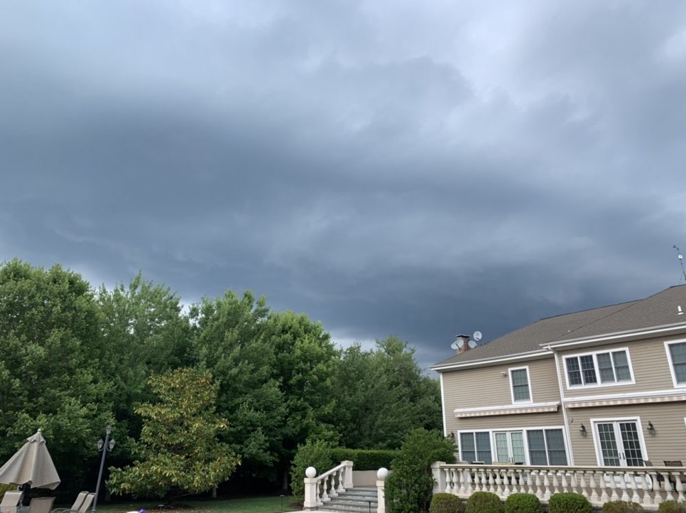
Gust front after passage:
-
4
-
-
1 hour ago, forkyfork said:
heat advects southwest from canada thurs-fri. totally normal and ok
2020 never fails to impress, just crazy.
-
-
1 minute ago, psv88 said:
Wow. That shower just exploded. Decent thunder too. Pouring
Guess it didn’t die out, haha. Enjoy the appetizer cell, I think today we see better storms later on the island.
-
Looks like a watch may be coming our way and for S NE
https://www.spc.noaa.gov/products/md/md1034.html
-
1
-
-
.10 in Syosset. Got hammered down by Wantagh at Brands Cycle, must have been close to .50 down there. Had some flooding on 135 heading home.
-
15 minutes ago, bluewave said:
I believe this is the first year that CAR and BTV beat both the May and June high temperatures at EWR and LGA. So far, it’s the warm season of onshore flow and the strongest heat going to our north.
CAR
May...91
Jun....96
BTV
May....95
Jun.....96
EWR
May....86
Jun....92
LGA
May....86
Jun....93
It’s the stagnant pattern. Some keep talking of 90+ constantly and it’s not happening. While we may get a day here or there, any talk of 90+ days consistently (heatwave) in the extended never happens as we get close to those forecasted hot days. Let’s just enjoy the mid to upper 80s for now, maybe 90 in the relaxation of onshore flow before it comes back yet again.
-
-
17 minutes ago, LibertyBell said:
I was away what was the high at JFK yesterday?
87 at 11:49 am
-
1
-
-
17 minutes ago, bluewave said:
It will be interesting to see how far north this record breaking SALcan get.
Should get to the mid-atlantic region perhaps. Ryan Maue has been posting on this for the past few days. His latest on the record depth of the SAL in the air.
-
Hit 90 in Syosset (89.6) & Muttontown (89.5). 1st 90 degree day for both.
-
88 so far in Muttontown & Syosset.


.png.ff24d41c0633aebc45b96b89824d9284.png)


July 2020 General Discussions & Observations Thread
in New York City Metro
Posted
Can only keep it at bay for so long. Was just a question of when and for how long once it arrives.