

uofmiami
-
Posts
1,637 -
Joined
-
Last visited
Content Type
Profiles
Blogs
Forums
American Weather
Media Demo
Store
Gallery
Posts posted by uofmiami
-
-
93/69/99 in Syosset & 92/63/94 in Muttontown
-
 2
2
-
-
17 minutes ago, SACRUS said:
A majority of Today's 12z guidance has a tropical storm near the SE/Carolinas around Aug 3rd. Way out there but with the WAR building west - how west will determine if any tropical system is an EC or FL/GOM track.
Definitely something to watch next week as it treks W towards the islands and perhaps East coast.
-
Just now, doncat said:
Agree it's like that every month...i went back and checked a while ago and those departure anomalies started suddenly, i think maybe a year and a half ago or so...prior to that the departures were in line with other sites.
How long has construction of new terminals, etc been going on for at LGA? Wonder if there is a correlation with that.
-
1 hour ago, lee59 said:
Yes all areas have risen but nighttime temperatures fall so much more in rural areas. I should add, especially on quiet nights with no wind.
All depends on how much pavement/concrete is around and closeness of houses to each other. I radiate well in N Syosset compared to when I lived in Great Neck. My parent’s house in Muttontown radiates even better than my house in Syosset. Flip side is unless it’s a hot day not a lock for 90 either. Both locations only hit 89 today for the high.
-
23 minutes ago, doncat said:
Euro shows dewpoints mixing down into the 50's for us during peak heat Sun and Mon.
Looks like Tuesday would be a heat advisory day for NYC on Euro, as DPs stay higher with wind going SW.
-
2
-
-
16 minutes ago, wdrag said:
Quick question: Am a little frustrated with MDL not posting MOS since 7/6 and I know NWS wants buy in on the NBM and is ready to discontinue, but myself, I like MOS as an idea of concerns. Is anyone able to acquire the GFS extended statistical guidance for locations in NJ and NYC... (not ALB). Just point me in the right direction. Thanks much,
Walt
Walt, try this link as MOS moved:
https://www.weather.gov/mdl/mos_getbull

-
 1
1
-
-
18 minutes ago, Rjay said:
88/65
I’m 85 now at both weather stations. DP is 63 in Muttontown and 70 in Syosset.
-
1
-
-
81/70/84 in Syosset & 83/69/87 in Muttontown
-
9 hours ago, dWave said:
After the 4pm climate summary
This is hilarious. Now the final daily climo says it happened at 3:11pm lol

Yet using 5 min obs it happened at 2 & 2:20 pm
https://www.wrh.noaa.gov/mesowest/getobext.php?sid=KJFK&table=1&num=168&banner=off
-
52 minutes ago, SACRUS said:
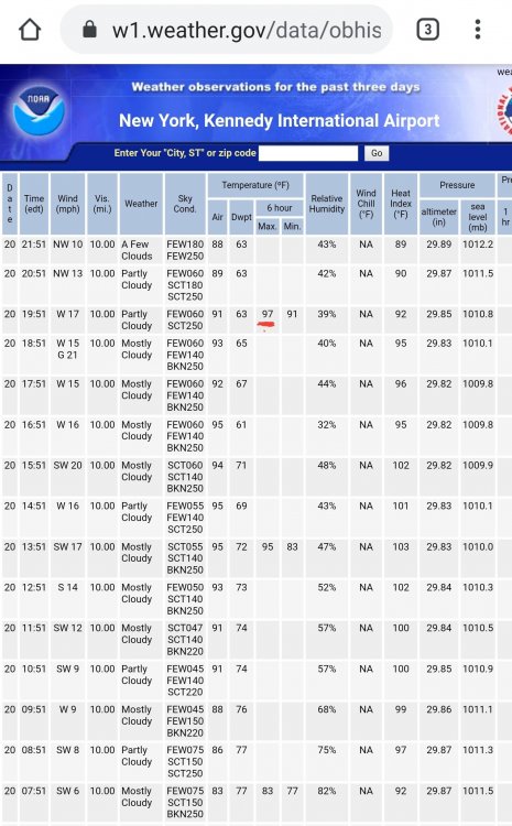
Don - JFK hit 97 inter-hour for max today.
What time? OKX has 96 for JFK, see picture from daily climate report.

-
Looks like 94.0 for the high in Muttontown & 93.3 in Syosset.
-
Hotter yesterday than today at this time though temps will end up hotter due to W winds. Currently 88/76/99 in Syosset & 89/75/99 in Muttontown.
-
Been stuck at 91 for the past hour or so since seabreeze boundary came up from S Shore it seems. Prior to arrival got to 92.6 in Syosset and 92.3 in Muttontown.
-
18 minutes ago, TriPol said:
What kind of car is this?
MB E-class wagon.
-
Remote started my car, just a tad toasty inside at 123.

-
3
-
 1
1
-
-
90 already in Syosset and Muttontown. Probably get to 95 or so at this rate.
-
Downpours from last night, almost .50, have temps lagging here in Syosset. Currently 81.6. Meanwhile in Muttontown, where only .10 fell last night, up to 84.
-
Almost .40 from the downpours in Syosset.
-
77/74 in Syosset & 77/72 in Muttontown.
-
10 minutes ago, Allsnow said:
Yep, the big heat is getting pushed back again. Any big heat pass day 5 Never makes it here
Yet the hottest day in NYC so far this summer wasn’t modeled to be that hot, as I recall.
-
2
-
-
I’m definitely concerned about hurricanes along the east coast if this pattern persists through the rest of summer, which I think it will do.
-
3
-
1
-
-
1 minute ago, nycsnow said:
What do you guys think for winds?
Maybe some gusts to 40 mph otherwise not much of a wind threat. Flooding from rain will be more of a concern.
-
2
-
-
Tropical Storm Fay Discussion Number   1
NWS National Hurricane Center Miami FL       AL062020
500 PM EDT Thu Jul 09 2020

Satellite and radar imagery, along with surface observations, have
shown that the area of the low pressure near the coast of North
Carolina reformed closer to the deep convection east of the Outer
Banks today.  An Air Force Reserve reconnaissance aircraft
investigating the disturbance this afternoon confirmed that the
center is located near the edge of the primary convective mass, and
that the system is producing an area of 35-40 kt winds to the east
and southeast of the center. Based on these observations, the
system is classified as a tropical storm with an initial intensity
of 40 kt.

Fay is located over the warm waters of the Gulf Stream and within an
area of light to moderate westerly shear.  These environmental
conditions could allow for slight strengthening tonight and Friday.
After that time, the circulation is forecast to interact with the
mid-Atlantic coast and will be passing over cooler waters north of
the Gulf Stream, likely limiting any further intensification.  Fay
should weakening quickly once it moves inland Friday night or
Saturday.

Since a new center has recently formed, the initial motion is a
highly uncertain 360/6 kt. Fay is expected to move generally
northward between a high pressure ridge over the western Atlantic
and an approaching mid-latitude trough.  The 12Z dynamical model
guidance has come into much better agreement on a track very close
to the U.S. mid-Atlantic coast. With the recent center
reformation to the northeast, the tracker guidance from the
dynamical models shows a track farther offshore than the model
fields imply.  As a result, the NHC track lies along the left side
of the guidance envelope but it is not as far west as what is
indicated in the model fields.

The NHC track and intensity forecast has required the issuance of a
Tropical Storm Warning for a portion of the U.S. coast from the
mid-Atlantic states to southern New England.

Key Messages:

1. Fay is expected to produce 3 to 5 inches of rain with isolated
totals of 8 inches along and near the track across the mid-Atlantic
states into southeast New York and southern New England. These rains
may result in flash flooding where the heaviest amounts occur.
Widespread river flooding is not expected at this time.

2. Tropical storm conditionsare expected along portions of the
mid-Atlantic and northeast coast Friday and Friday night, and a
Tropical Storm Warning has been issued for the coasts of New Jersey,
New York and Connecticut, including Long Island.

FORECAST POSITIONS AND MAX WINDS

INIT  09/2100Z 35.5N  74.9W   40 KT  45 MPH
 12H  10/0600Z 37.1N  74.7W   45 KT  50 MPH
 24H  10/1800Z 39.0N  74.3W   45 KT  50 MPH
 36H  11/0600Z 41.6N  73.6W   35 KT  40 MPH...INLAND
 48H  11/1800Z 45.3N  72.4W   25 KT  30 MPH...INLAND
 60H  12/0600Z 49.1N  70.3W   20 KT  25 MPH...POST-TROP/EXTRATROP
 72H  12/1800Z...DISSIPATED

$$
Forecaster Brown
-
Flood Watch
National Weather Service New York NY
405 PM EDT Thu Jul 9 2020

...FLASH FLOODING POSSIBLE FRIDAY INTO FRIDAY EVENING...

CTZ005>012-NJZ002-004-006-103>108-NYZ067>075-078>081-176>179-
100915-
/O.NEW.KOKX.FF.A.0001.200710T1000Z-200711T0400Z/
/00000.0.ER.000000T0000Z.000000T0000Z.000000T0000Z.OO/
Northern Fairfield-Northern New Haven-Northern Middlesex-
Northern New London-Southern Fairfield-Southern New Haven-
Southern Middlesex-Southern New London-Western Passaic-
Eastern Passaic-Hudson-Western Bergen-Eastern Bergen-
Western Essex-Eastern Essex-Western Union-Eastern Union-Orange-
Putnam-Rockland-Northern Westchester-Southern Westchester-
New York (Manhattan)-Bronx-Richmond (Staten Island)-
Kings (Brooklyn)-Northwestern Suffolk-Northeastern Suffolk-
Southwestern Suffolk-Southeastern Suffolk-Northern Queens-
Northern Nassau-Southern Queens-Southern Nassau-
405 PM EDT Thu Jul 9 2020

...FLASH FLOOD WATCH IN EFFECT FROM FRIDAY MORNING THROUGH FRIDAY
EVENING...

The National Weather Service in Upton has issued a

* Flash Flood Watch for Southern Connecticut, Northeast New
  Jersey, the Lower Hudson Valley, New York City and Long Island.

* From Friday morning through Friday evening.

* Heavy rain showers and embedded thunderstorms are forecast
  Friday into Friday evening. A total of 1 to 3 inches of rainfall
  is forecast with locally higher amounts possible. Torrential
  rainfall within a short period of time will be possible and this
  could lead to flooding of low lying, urban and poor drainage
  areas. Some smaller streams and rivers could exceed bankfull.

PRECAUTIONARY/PREPAREDNESS ACTIONS...

A Flash Flood Watch means that conditions may develop that lead
to flash flooding. Flash flooding is a very dangerous situation.
You should monitor later forecasts and be prepared to take action
should flash flood warnings be issued.


July 2020 General Discussions & Observations Thread
in New York City Metro
Posted
I don’t think I’m getting the seabreeze in N Nassau, appears to be S of me.