

uofmiami
-
Posts
2,094 -
Joined
-
Last visited
Content Type
Profiles
Blogs
Forums
American Weather
Media Demo
Store
Gallery
Posts posted by uofmiami
-
-
2 hours ago, Sundog said:
I hear both all the time. By the time the roar of the first plane is about to totally dissipate I hear the whine of the next plane approaching.
Ever since 2012 LGA permanently switched over to the "Tennis Climb," which they used to use only to avoid the US Open.
That puts the planes right over eastern Queens. Not only that, but the frequency of flights has gone through the roof with updated technology and they also fly 1000 feet lower, which all just compound the noise problem.
https://qns.com/2025/09/meng-quiet-communities-act-aircraft-noise-queens/
And I know the towns of Hempstead and North Hempstead are suing the FAA.
I get non-stop planes overheard on approach into JFK runway 22 now at 1800 to 2000 over my house & my parent's in Muttontown. Can always tell a 747 by the sound alone. While planes flew over Great Neck from LGA when I was kid & lived for 30 or so years, they were always at a higher altitude so not as noisy in my experience.
-
 3
3
-
-
80.5 in Muttontown & 80.2 in Syosset today.
-
2
-
-
2 minutes ago, Sundog said:
Where do you see that?
Florida
-
2
-
 3
3
-
-
-
46.0 in Muttontown & 48.1 in Syosset this morning.
-
83.0 in Muttontown & 82.3 in Syosset for the high.
-
1
-
-
81.3 in Muttontown & 81.1 in Syosset for the high.
-
1
-
-
2 minutes ago, donsutherland1 said:
I meant for this to be in the banter thread, but the point is that one has to use established definitions consistently for clear communication. Otherwise, confusion can erode preparedness and public safety.
Understood, totally agree.
-
1
-
-
10 minutes ago, donsutherland1 said:
Perhaps because his tropical forecast is in bad shape due to a quiet hurricane season so far, Joe Bastardi is now insisting that meteorologists embrace his private fiction of what constitutes a tropical cyclone.
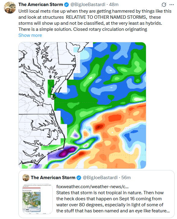
As noted previously, the system had fronts. It was a nor'easter. It was not a tropical cyclone. It should not have been classified as a tropical cyclone any more than a winter nor'easter should be classified as a tropical storm or hurricane.
Well compared to naked swirl aka Gabrielle, maybe he has a point, haha I don't get how Gabrielle exists at the moment.
-
16 minutes ago, Sundog said:
The stuff currently south of Long Island is better lined up for NYC if it can make it there.
Agreed, just watch how it pinwheels in to the area on radar this evening.
-
1
-
-
1 hour ago, Sundog said:
Models are wishy washy with how much rain falls up here
They mostly all bring the low up here to affect us, they just differ in how much rain actually falls once it's here.
Hopefully around .25" falls, but could end up closer to .10"
-
24 minutes ago, bluewave said:
Maybe you should try posting some of your own ideas instead of being more concerned about trying to play gotcha games.
I do, I busted horribly back in fall of last year calling for a cooler November, as I recall. It's called forecasting, you'll never be correct all the time in weather. I just don't delete my posts when the forecast of it ends up incorrect.
-
 1
1
-
 1
1
-
-
2 minutes ago, bluewave said:
I posted yesterday that the heaviest rain would stay to our south due to the record blocking to our north which is still the case today. I didn’t mention any specific amounts since the models haven’t been very good recently in that regard beyond a few days out
That's why it's deleted but the 90 for Friday posts remain

-
1
-
-
55 minutes ago, bluewave said:
You know it’s a dry pattern when the main interest is how close the .50 line gets to NYC.
Well you did post yesterday, which I see you since deleted, that the record ridge over SE Canada was going to keep the moisture to our S. We'll take whatever QPF falls, but this was hinted on some models early Monday morning (6Z Euro, NAM & GFS). Glad to see some better agreement that they'll be some QPF at least.
-
1
-
-
1 hour ago, the_other_guy said:
Anyone else find it humid out?
Not me down here on Long Island.
-
36 minutes ago, Sundog said:
Are the overall anomalies being affected by higher low temps?
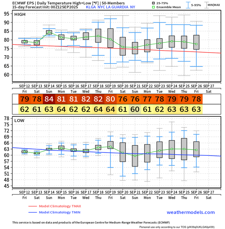
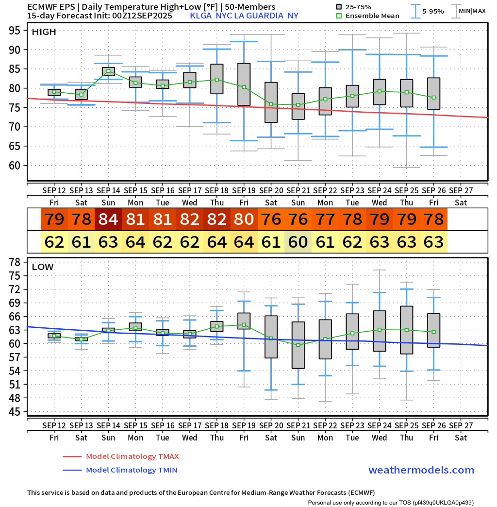
I don't see any temps higher than upper 70s on the EPS.
Looks like low 80s on EPS, regardless it’s above normal.
-
48.6 in Muttontown & 50.6 in Syosset this morning.
-
1
-
-
49.1 in Muttontown & 51.4 in Syosset this morning.
-
2
-
-
1.37” in Syosset & 1.14” in Muttontown for rainfall totals.
-
1.32” in Syosset & 1.10” in Muttontown so far.
-
1
-
-
11 minutes ago, psv88 said:
Solid drink, up to 0.87”. Hasn’t rained like that in a long time.
So much for the models having nothing for Suffolk
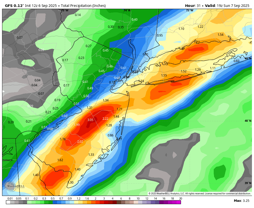
 GFS is looking good
-
2
-
-
-
8 minutes ago, allgame830 said:
Looks like that rain to the south over the Delmarva is more aimed towards LI and southern parts of the metro. I could be wrong but that’s what it looks like
Radar seems to indicate metro on east is best for the additional rains this evening.
-
2 hours ago, psv88 said:
Models show very little rain for Suffolk county. The beat goes on
GFS has you covered
-
2
-


September 2025 OBS-Discussion centered NYC subforum
in New York City Metro
Posted
0.87” in Syosset & 0.52” in Muttontown.