

uofmiami
-
Posts
2,094 -
Joined
-
Last visited
Content Type
Profiles
Blogs
Forums
American Weather
Media Demo
Store
Gallery
Posts posted by uofmiami
-
-
23 degree drop in 1hr in Syosset. 77 to 54 currently. 48 just N of me in Oyster Bay on the water.
-
Winds went NE here in Syosset, currently 77
-
 1
1
-
-
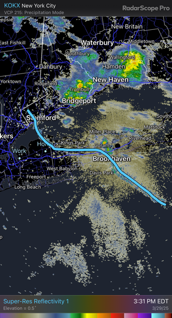
BDCF showing up nicely on radar
-
-
Leading edge of clouds with BDCF coming through Stillwell park currently.
-
Pushing 77 at my stations. 80 by 2pm, if not sooner.
-
Newark going to definitely hit 80. 79 at 12pm there.
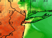
New York City Metropolitan Area Weather Roundup
National Weather Service New York NY
1200 PM EDT SAT MAR 29 2025

CITY           SKY/WX    TMP DP  RH WIND       PRES   REMARKS
Central Park   MOSUNNY   75  45  34 W9G20     29.96F
LaGuardia Arpt PTSUNNY   75  45  34 SW13G24   29.93F
Kennedy Intl   PTSUNNY   71  49  45 SW18      29.96F
Newark Liberty PTSUNNY   79  47  32 W16G41    29.94F
Teterboro Arpt SUNNY     76  49  38 W18G33    29.93F
Bronx Lehman C   N/A     73  48  40 W8          N/A
Queens College   N/A     73  48  40 W14G26      N/A
Breezy Point     N/A    N/A N/A N/A W10G16      N/A
Brooklyn Coll    N/A     73  46  38 W15         N/A
Staten Island    N/A     75  48  38 W16         N/A
-
71 in Syosset & Muttontown, made it into the 70s finally. Curious to see if 80 can be reached before BDCF arrival.
-
1
-
-
4 minutes ago, Sundog said:
12z 3K NAM now brings the colder air back on a NE wind to NYC by 5PM:
I have to check 12Z compared to 6Z I know NE Nassau was 3-4pm timeframe. Seems like 12Z may have sped that up by an hour.
-
1
-
-
1 minute ago, snowman19 said:
Mark Margavage posted on twitter that because 0.1 of rain fell last night that it’s impossible that PA is going to see 80 degree temps today because of evaporational cooling. Total clown
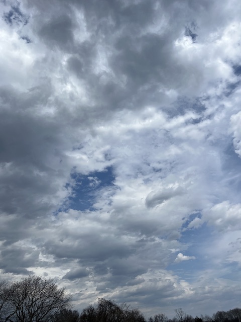
Clouds may be the bigger issue, though appears clearing is getting wider in scope, so temps should be able to rise under full sun.
-
3 minutes ago, qg_omega said:
Not seeing upper 50s on Sunday, looks like maybe 50 but likely 40s all day
Midnight temps will be the high for the day (Sunday) potentially, especially along the coast.
-
17 minutes ago, jm1220 said:
NAM still insisting on a faster backdoor tomorrow afternoon makes me nervous for LI. These very often come in stronger and faster than expected. It’s some very chilly air to our north. Might be one of those where we can literally see the stratus deck come in from the east.
As long as it holds off until after 4pm I’m fine. I don’t want to be watching my kids sports and go from warmth to cold during their games.
-
2
-
-
Snowing in S Syosset/Plainview area based on Travel Baseball group chat.
-
4 minutes ago, Sundog said:
I will disagree with the last part, even 50 degrees with Sun is VERY comfortable to do anything outdoors this time of year save water based activities.
Agreed, assuming we can hold off the wind.
-
1
-
-
17 minutes ago, bluewave said:
How far north the warm front gets on Saturday will be determined by which of the two high pressure systems are stronger. If the Bermuda high is stronger like in recent runs, then the warm front will come further north. But if the Canadian high is stronger than there will be more if a struggle to come north. Since the temperature gradient is so steep, there could be a 30°+ temperature shift over a few miles. So we are getting the 0z to 12z windshield wiper effect until we get close enough for one solution to win out.
New run stronger Bermuda high and warm front further north

Old run Canadian high stronger so warm front further south

Too early for stronger Bermuda High, Canadian will win out IMO. Probably around 55 for Central Park on Saturday.
-
.69 in Muttontown & .80 in Syosset
-
1
-
-
4 minutes ago, psv88 said:
29 this morning. Keep the bugs at bay
30 at my stations. I feel like everything is delayed by 2-3 weeks before we’ll be inundated with bugs, pollen, etc.
-
1
-
-
5 minutes ago, bluewave said:
Warm pattern for early April as the Southeast Ridge links up again with the Greenland Block.


I’ll wait until inside 96hrs before getting hyped for warmth along coast here on LI. Hope the warmth doesn’t end up further W for Plains into Ohio Valley.
-
2 minutes ago, Sundog said:
Where are there leaves popping in our area? I see nothing.
Unless I'm misunderstanding this map.
Pear trees are close to popping in Great Neck but haven’t yet. Curious if NYC has any trees with leaves starting.
-
1
-
-
-
Wind must have taken something down, as I’m on generator power now. Gusts have been in the mid 30s.
-
1
-
-
2 minutes ago, Brian5671 said:
south winds-so we are capped given the water temps-60 here as well
Can add my two stations to 60 for the high as well. Winds on S Shore with temp around 54 & no sun made it feel like the 40s this afternoon in Massapequa for my daughter’s flag football game.
-
1
-
-
6 minutes ago, jm1220 said:
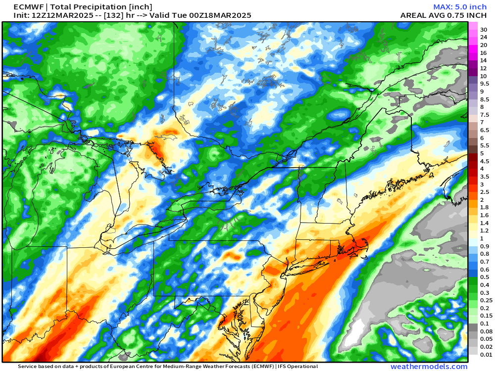
Awesome. Wildfires and drought=bad. Get it a little further west to fill the reservoirs.
Let's hope the model doesn't lower QPF as we approach the event.
-
2 minutes ago, forkyfork said:
12z euro is west
-
2
-


April 2025 Discussion/Obs
in New York City Metro
Posted
What temp did you turn thermostat down to?