

uofmiami
-
Posts
1,637 -
Joined
-
Last visited
Content Type
Profiles
Blogs
Forums
American Weather
Media Demo
Store
Gallery
Posts posted by uofmiami
-
-
-
-
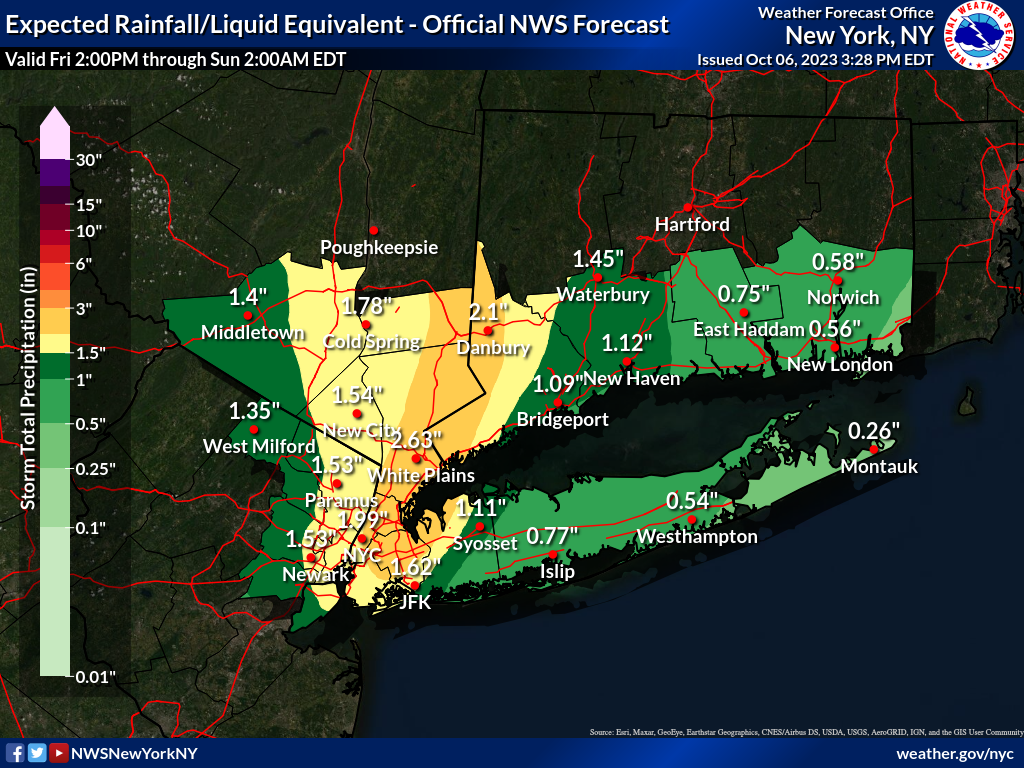
Flood Watch issued for parts of OKX:
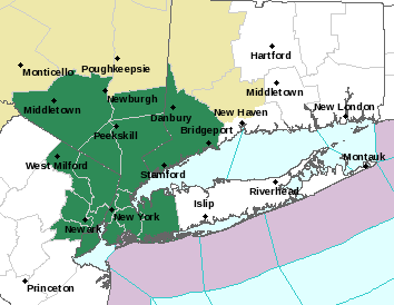
Flood Watch National Weather Service New York NY 312 PM EDT Fri Oct 6 2023 CTZ005-009-NJZ002-004-006-103>108-NYZ067>075-176>179-071000- /O.NEW.KOKX.FA.A.0011.231007T0600Z-231008T0000Z/ /00000.0.ER.000000T0000Z.000000T0000Z.000000T0000Z.OO/ Northern Fairfield-Southern Fairfield-Western Passaic-Eastern Passaic-Hudson-Western Bergen-Eastern Bergen-Western Essex- Eastern Essex-Western Union-Eastern Union-Orange-Putnam-Rockland- Northern Westchester-Southern Westchester-New York (Manhattan)- Bronx-Richmond (Staten Island)-Kings (Brooklyn)-Northern Queens- Northern Nassau-Southern Queens-Southern Nassau- 312 PM EDT Fri Oct 6 2023 ...FLOOD WATCH IN EFFECT FROM 2 AM EDT SATURDAY THROUGH SATURDAY EVENING... * WHAT...Isolated to scattered instances of flash flooding caused by excessive rainfall are possible, which could be locally significant. * WHERE...Portions of southern Connecticut, including the following areas, Northern Fairfield and Southern Fairfield. Portions of northeast New Jersey, including the following areas, Eastern Bergen, Eastern Essex, Eastern Passaic, Eastern Union, Hudson, Western Bergen, Western Essex, Western Passaic and Western Union. Portions of southeast New York, including the following areas, Bronx, Kings (Brooklyn), New York (Manhattan), Northern Nassau, Northern Queens, Northern Westchester, Orange, Putnam, Richmond (Staten Island), Rockland, Southern Nassau, Southern Queens and Southern Westchester. * WHEN...From 2 AM EDT Saturday through Saturday evening. * IMPACTS...Excessive runoff may result in local to scattered areas of flash flooding of poor drainage and urban areas. Flooding of rivers, creeks, streams, and other low-lying and flood-prone locations is also possible. Creeks and streams may rise out of their banks. * ADDITIONAL DETAILS... - Widespread 1.5 to 2.5 inches of rainfall, with locally 3 to 4 inches, are possible, especially where the axis of heavier rain develops, and possibly remains for an hour or two. Rainfall rates to 1 to 2 inches per hour are possible. If and where the heaviest rainfall rates develop the flooding could be locally significant, causing disruption to transportation, flooding of basements, first floor residences and businesses, and underground infrastructure, and pose an elevated threat to life. - http://www.weather.gov/safety/flood-
 1
1
-
-
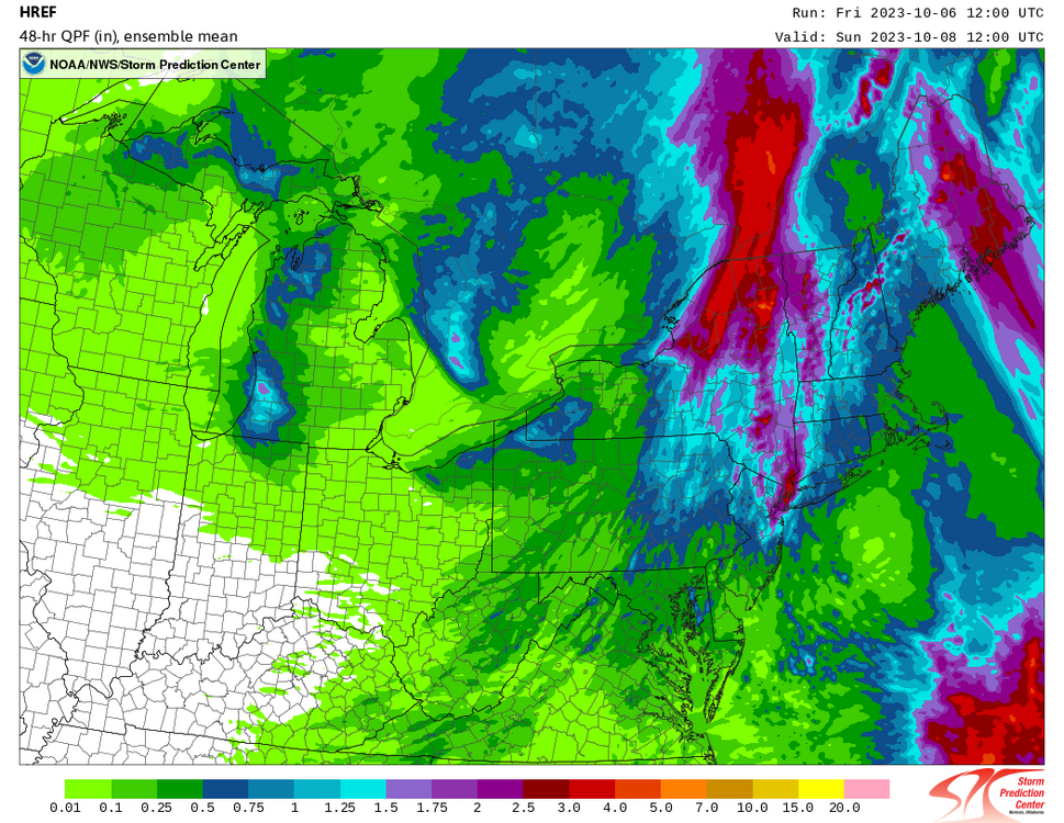
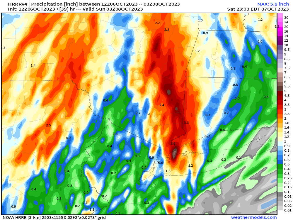
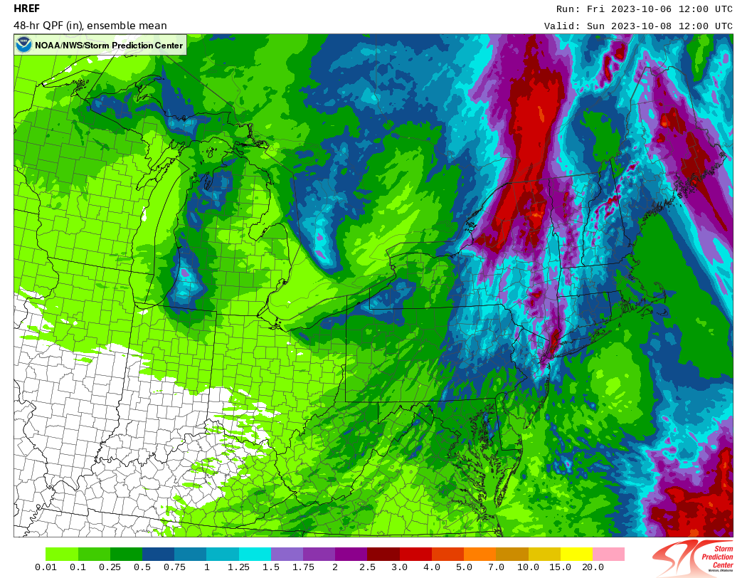
SPC HREF:
-
11 minutes ago, Brian5671 said:
Extended HRRR crushes the NY/CT line with several inches of rain
Looks similar to what euro has been showing.
-
83.5 (84) in Syosset & 83.2 in Muttontown.
-
-
79.5 (80) in Syosset & 78.3 in Muttontown.
-
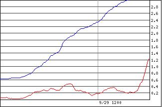
5.05” in Syosset & 4.32” in Muttontown for the event. Should be final, as event looks done this way finally.
-
Eclipsed 5” in Syosset. 5.02” & still raining.
-
1
-
 1
1
-
-
15 minutes ago, jm1220 said:
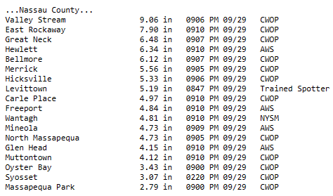
Highest in the area looks to be Valley Stream. @uofmiami you should send your Syosset total in. I would think Hewlett would be higher than East Rockaway. If the radar estimate matters, Atlantic Beach/Lawrence/Inwood probably had over 10" then.
Sometimes they take my stations from CWOP without me having to submit it. My Muttontown station they did I see. Looks like I’ll have to submit my syosset one. Thanks for the heads up.
-
1
-
-
4.82” in Syosset & 4.14” in Muttontown.
-
2
-
-
-
-
8 minutes ago, psv88 said:
It’s definitely low. Getting crushed here now. These wind gusts are more concerning than the rain at this point.
flash flood warning for Suffolk now
25-30 mph then they drop off once the firehose moves past.
-
-
Just now, SI Mailman said:
I’ve only had about .02 inches since 11 am, so I’ve been able to deliver without a canoe today. 2.09 inch storm total so far.
Amazing what could have been if the heaviest was only further W this morning. Glad you didn't have it as bad as it could have been.
-
11 minutes ago, jm1220 said:
It’s absolutely pouring here and I’m over 2” now per radar. Heavy rain goes back to around Westbury and it’s not moving fast. We won’t get what the city/Nassau got but we’re in for a rough couple hours.
My backyard is a lake & my front side yard has a moat with my neighbor. 4.31" now and pouring in Syosset.
-
1
-
-
3.56' in Syosset now & coming down hard. 3 miles W in Muttontown only 3.21"
-
-
2 minutes ago, LongBeachSurfFreak said:
I’m worried about going home. If that line continues east I’ll have to head to my dads in wantagh to pump his basement. He’s in Spain currently. So two places to worry about.
Unfortunately, watching the radar it's moving slowly east. Sorry to hear you'll have to deal with that as well.
-
SW Nassau seeing 1.5"/hr rainfall accumulation. Has to be bad flooding down there now.
-
3.08" in Syosset & 2.90" in Muttontown
-
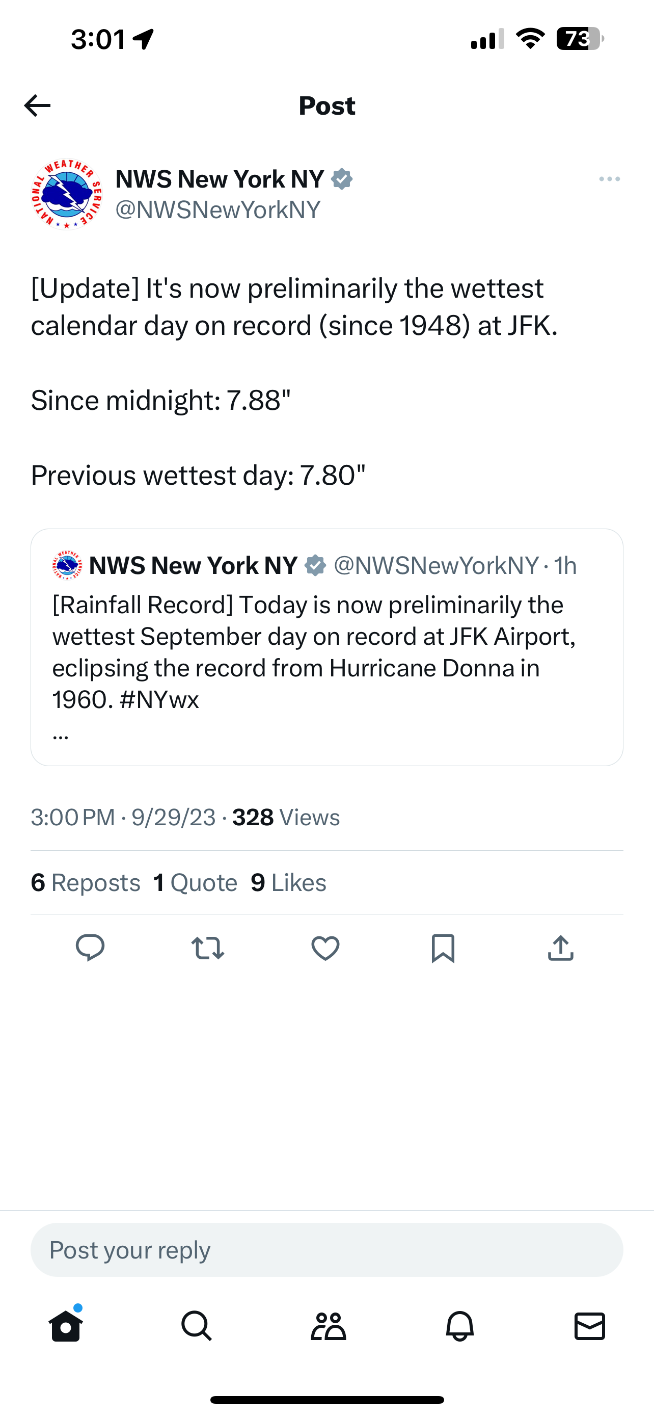
I can't get twitter links to post all of a sudden. Anyway:
Flash Flood Warning continues for Brooklyn NY, Queens NY and Hempstead NY until 2:45 PM EDT

October 2023
in New York City Metro
Posted
Here’s 6Z euro map