

uofmiami
-
Posts
1,641 -
Joined
-
Last visited
Content Type
Profiles
Blogs
Forums
American Weather
Media Demo
Store
Gallery
Posts posted by uofmiami
-
-
SW Nassau seeing 1.5"/hr rainfall accumulation. Has to be bad flooding down there now.
-
3.08" in Syosset & 2.90" in Muttontown
-
I can't get twitter links to post all of a sudden. Anyway:
Flash Flood Warning continues for Brooklyn NY, Queens NY and Hempstead NY until 2:45 PM EDT

-
Just now, forkyfork said:
We can only hope for a repeat then.
-
2 minutes ago, forkyfork said:
prayers for all the rats drowning today
They'll be swimming and enjoying themselves unfortunately
-
Just now, bluewave said:
This event will rank near the top for NYC flash flooding only a few years after Ida.
Yet no Flood Emergency was issued that I have seen, only warnings so far.
-
 1
1
-
-
2.50" in Syosset & 2.39" in Muttontown at the moment.
-
1
-
-
-
1.62” both my stations and pouring.
-
1.33” in Muttontown & 1.39” in Syosset so far.
-
-
2 minutes ago, Allsnow said:
Here's weathermodel's image at 54hrs:

-
2
-
 1
1
-
-
-
3 minutes ago, psv88 said:
NJ can keep it’s rain!
My sons baseball will definitely be cancelled Saturday morning again. Haven’t played in 3 weeks. Sick of this crap.
Going on 3 weeks for my son as well. Practice was cancelled yesterday, field was still not dry.
Shall see if his Friday night flag football game gets cancelled, though the field in Massapequa is all turf.
-
1
-
-
1 minute ago, Brian5671 said:
Flood watches up for most of upton's territory
2-4" with excess of 5" in spots from 2am tomorrow until late tomorrow night. Oh joy!!
-
1
-
-
7 minutes ago, Snowlover11 said:
of course KDIX would go down

Status message from 12:06 pm says "KDIX is spinning again. - po"
-
1
-
-
5 minutes ago, jm1220 said:
New UKMET has 10.5” rain at Islip, looks just like Aug 2014 again with amounts/distribution. Upton should really be issuing watches soon.
I'm sure they'll go out on the afternoon update, usually around 3pm. I agree they should issue the watch now though.
-
14 minutes ago, 495weatherguy said:
100% agree with you-No one needs this. That being said, how many times has the "bullseye" been correct on these types of storms?
Agreed. It could 50-100 miles east or west, just have to watch radar as the storm unfolds. Hopefully it happens out to sea, so no one has to deal with the flooding that would accompany those totals.
-
1
-
-
25 minutes ago, Brian5671 said:

No thank you. I’ll pray that’s wrong, otherwise it’s ark building time.
-
1
-
-
24 minutes ago, lee59 said:
Gloria hit eastern Nassau and east the hardest. Numerous trees down and many lost power for days. The hype with Gloria was very high, so areas from the city on West that didn't get the strongest winds might have felt it was not so bad. If it hit at high tide, coastal flooding would have been much worse. I believe the center past close to the Nassau Sulfolk border.
My grandma’s house in Islip had tons of tree damage and huge limbs down all over the place. The wind snapped the trees tops down on her side yard and knocked off a street light on power pole across street. Lots of power lines down. Compared to Great Neck where we had some gusts and a branch or two down.
-
36 minutes ago, MJO812 said:
Cmc pretty wet for Friday
Another 2-4" of rain, no thank you!!

-
1
-
-
Assuming the rain is done, 2.39" in Muttontown & 2.50" in Syosset.
-
2.05” at Syosset & 1.93” at Muttontown so far.
-
4 minutes ago, Nibor said:
Some decent wind gusts rolling through Astoria right now.
Had the same on the island and temp dropped to 56 at both my stations.

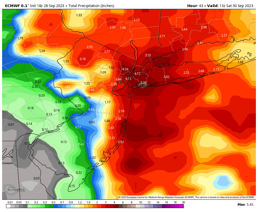


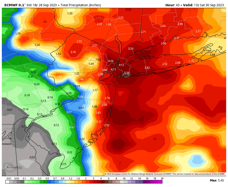
Another big Sept rain event between roughly midnight Friday morning and midnight Sunday morning (bulk 9/29-30/2023)
in New York City Metro
Posted
Unfortunately, watching the radar it's moving slowly east. Sorry to hear you'll have to deal with that as well.