

uofmiami
-
Posts
1,648 -
Joined
-
Last visited
Content Type
Profiles
Blogs
Forums
American Weather
Media Demo
Store
Gallery
Posts posted by uofmiami
-
-
2 minutes ago, Brian5671 said:
GFS doing GFS things in the LR....would need to see other models with the same idea before I even remotely considered it.
Definitely something to watch IMO. Lots can change in the extended, that's for sure.
-
52 minutes ago, psv88 said:
That's lower than any other local ASOS station. Even the park has a DP of 69
Some are 68 on the region roundup at 12pm. Looks like upper 60s (69) now at the majors at 1pm. JFK is 70.
-
12 minutes ago, psv88 said:
"It will be a dry heat" they said...dewpoints on the island all above 70...
66 DP in Muttontown currently.
-
13 minutes ago, psv88 said:
Islip 88/65, FRG 89
ISP benefiting from a N wind so far this morning. Winds just went S to SW so I’m sure ISP hit their high for the day if winds stay that direction.
-
7 hours ago, psv88 said:
Islip has been low all summer. Sure the east end always is cooler for the most part…but isp is not on the water and is not comparable at all to FOK. It is more comparable to FRG and shouldn’t be a full 6 degrees cooler. when JFK and FRG both hit 90 and isp at 84, somethings off
Go check the METAR data and wind direction, says it all. ISP was S all day long yesterday, hence the temp difference.
-
1 minute ago, SnoSki14 said:
Dews are in the mid 60s so it's not that low.
But today is just the beginning. The next few days will be very hot and I bet we'll see advisories go up.
Read OKX AFD, lots of mixing & lower DPs during height of temps during the day. LGA shows this today, went to upper 50s. EWR dropped to 61 I see quickly.
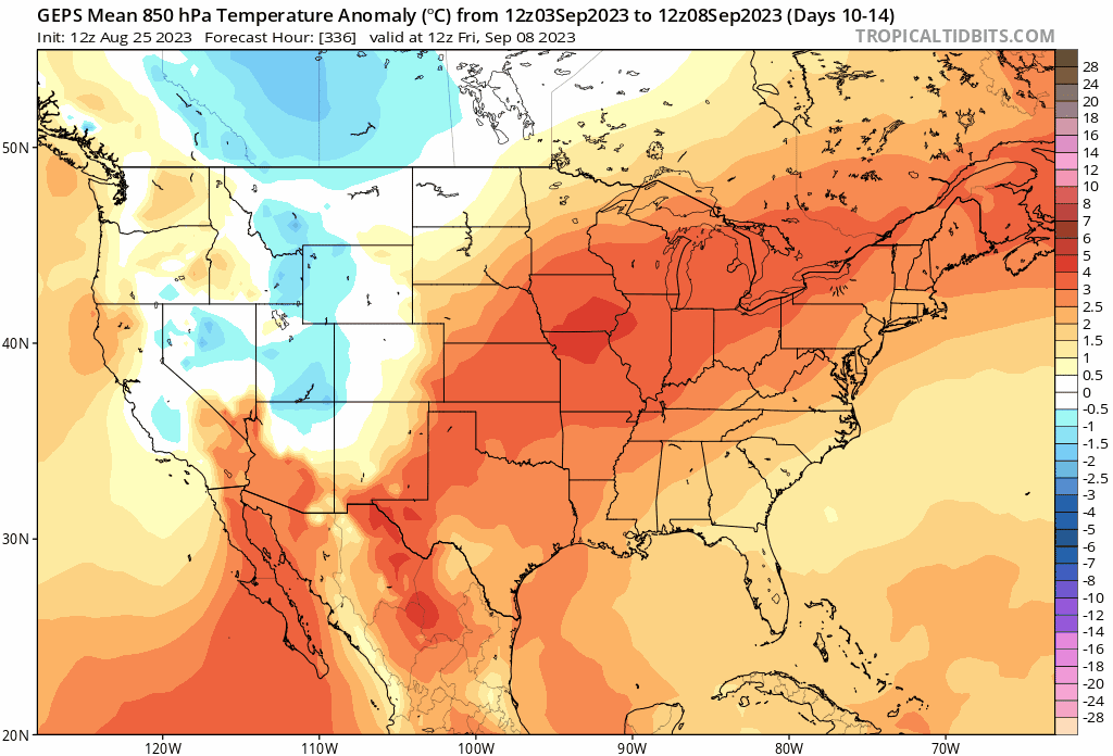
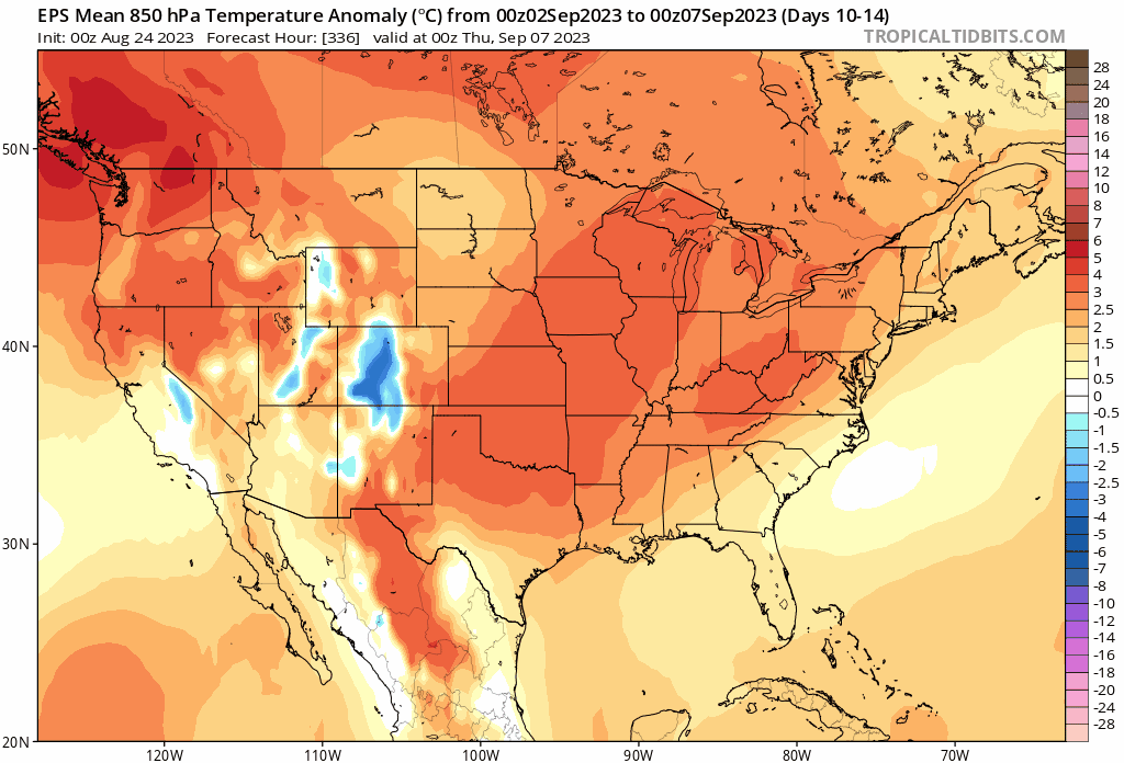
BUFKIT soundings prog 850 mb temperatures around 20C on Monday, and with a well-mixed BL, surface temperatures should climb into the high 80s and low 90s in the afternoon for most, or about 10 degrees above normal. Surface high pressure centered over the Southeast provides a light westerly flow, except where coastal sea breezes develop and back winds southerly in the afternoon. An upper disturbance rounding the ridge will allow for some mid and high level clouds during the day, but precipitation is not expected. It remains mild overnight into Tuesday, with the metro only falling into the mid 70s. The ridge slides overhead Tuesday, with similar, if not a smidge warmer, conditions expected. Continued deep mixing likely allows dew pts to fall below NBM both days as often the case. Blended in the 10th percentile as a compromise, yielding low to mid 60s during the day. Its possible the low-levels dry out a bit more than forecast, and this is the challenge as it comes to heat headlines. -
87 in Muttontown & 88 in Syosset today.
-
3 hours ago, forkyfork said:
canadian ensemble trending in that direction

Heat going up and over us. You can’t catch a break with your heat desire.
-
29 minutes ago, forkyfork said:
the trend is your friend

When this is inside 120hrs let me know. Seen too much long range heat fade away this summer. Can still see highest temps will be to our west as has been the theme all summer.
-
 7
7
-
-
27 minutes ago, Brian5671 said:
he's even given up posting day 15 GFS wishcast maps...
He's moved on to posting 90 day+ maps for the winter torch that's incoming.
-
 3
3
-
-
85 both my stations.
-
5 minutes ago, psv88 said:
57. Crisp
Same this morning at my stations.
-
1
-
-
21 minutes ago, forkyfork said:
not as devastated as you will be when january is +7. also how did we get a top ten warm july if heat has no staying power
Because the warm overnight lows with high DPs skewed temps, that's how.
-
3
-
 2
2
-
-
1.20” in Syosset & .63” in Muttontown.
-
6 minutes ago, Wxoutlooksblog said:
I see them all the time.
WX/PT
They are in Great Neck. Office building was crawling with them Friday when I went to get a file from storage unit. Haven’t seen any in Syosset or Muttontown yet but I’m sure they are around.

-
1 minute ago, jm1220 said:
Up to about 0.3” here, maybe a little more. I don’t see any LI location with over about 0.45” per radar estimate. SW Nassau/near Queens has the most. Southern half of the island is mostly 0.25 or under.
.26 in Muttontown & .30 in Syosset currently. End up under .50" when this is done most likely.
-
2
-
-
-
1 hour ago, the_other_guy said:
I think this worked out really nicely for the area. Got a lot of nice rain this morning. Hopefully killed T storm chances for later.
I can tell you on the aviation front we can’t take many more days with these severe lines coming through. It’s been a terrible summer operationally because of them.
Aviation twitter has been going crazy all summer. From FAA staffing issues to the weather, it's been a nightmare for passengers as well as flight crews this summer. I saw diversions over the SE yesterday due to T-storms.
-
1
-
-
39 minutes ago, MJO812 said:
Looks like a rainy Monday and Tuesday coming up.
I hope the rain misses the NYC metro area on Tuesday because I have family day at work.
Quick look at models shows 1st batch of rain for tomorrow morning. 2nd batch is overnight into early Tuesday morning with warm front. Maybe later Tuesday as front moves through we’ll see another round. Overall I think you’ll be ok for family day at work on Tuesday.
-
54 in Muttontown & 56 in Syosset this morning.
-
1
-
-
58 in Syosset & 57 in Muttontown this morning. Seems outside UHI areas it was 50s for everyone.
-
2
-
-
To add from Ryan Maue met summer to date:

-
1
-
-
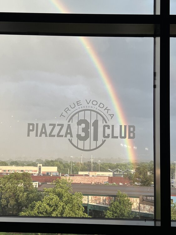
Rainbow while waiting for the Mets game to start on the rain delay.
-
6
-
-
2 hours ago, psv88 said:
Hit 91 today, day 4 of heatwave.
90 (89.6) for Muttontown, so a heatwave there. Came up just short in Syosset, 89.1 for the high.
-
1
-


September 2023
in New York City Metro
Posted
90 at both my stations today