

uofmiami
-
Posts
1,637 -
Joined
-
Last visited
Content Type
Profiles
Blogs
Forums
American Weather
Media Demo
Store
Gallery
Posts posted by uofmiami
-
-
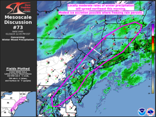
https://www.spc.noaa.gov/products/md/md0073.html
Mesoscale Discussion 0073
   NWS Storm Prediction Center Norman OK
   0749 AM CST Tue Jan 16 2024

   Areas affected...Parts of the Mid Atlantic into southern New England

   Concerning...Winter mixed precipitation

   Valid 161349Z - 161745Z

   SUMMARY...Locally moderate winter precipitation rates will spread
   northeastward this morning, with some modest ice accretion possible
   where freezing rain persists.

   DISCUSSION...A surface low currently off of the Mid Atlantic coast
   is forecast to gradually deepen as it moves northeast toward coastal
   southern New England this morning. Multiple waves of light to
   locally moderate precipitation are ongoing and will continue to
   spread northeastward in conjunction with the surface low. While
   interior portions of the Northeast will likely continue to see snow
   (with generally light to moderate rates) this morning, low-level
   warm advection will support a transition from snow to sleet across
   parts of southern New England, with freezing rain persisting over
   portions of the Mid Atlantic region.

   As the low deepens offshore, a modest uptick in precipitation
   intensity will be possible through the morning. While rates will
   likely remain light to locally moderate, antecedent cold conditions
   (with temperatures initially in the 20s F) may result in relatively
   efficient ice accretion in areas that transition to freezing rain.
   Pockets of moderate sleet/snow will also be possible into parts of
   southern New England. Low-level warm advection will support a
   gradual transition to rain along the Mid Atlantic and southern New
   England coasts, but subfreezing temperatures may persist inland
   through the morning.
-
-
2” here in N Syosset sent to OKX. 28 & snowing currently.
-
2 minutes ago, Edubbs83 said:
Snow started on north shore here in Syosset area.
.I can confirm that.
-
10 minutes ago, NorthShoreWx said:
NW Suffolk has a shot.
I’m sure they’ll get 3”. I wouldn’t worry about being under the advisory really. We are getting measurable snow & it’s long overdue.
-
 2
2
-
-
-
-
-
1 minute ago, Rjay said:
Feet are always the worst. Giants/Green Bay playoff game in GB , Jets/Steelers snowstorm changing to 33 and rain game and Islanders/Rangers at Yankee Stadium were the 3 most uncomfortably cold experiences of my life.
I had Foxboro to see the Pats/Jets back in 1991. Uncle had season ticket for Pats. Low 30s and windy as hell. Couldn’t feel my feet/hands and ass was frozen from metal bleachers at that stadium. Good times as a teenager.
-
1.55” for the storm with peak gust of 33mph.
-
-
-
5 days out I’d be skeptical of all guidance. Let’s get this next storm out of the way and hopefully by 12Z Saturday runs there’s consensus as to what to expect for Tuesday.
-
2
-
-
Just now, Brian5671 said:
some of the dead wood fell during the Dec storms too...not much fell around here last night....
Saw a tree with severe rot in the trunk split in two on way to work in someone's front yard in Oyster Bay Cove. Otherwise, I think most of the dead wood, etc fell in prior Dec storms.
-
1 minute ago, guinness77 said:
After I took much care with my 2 cans (put them out after the squall line, and flooding, with bricks on top of both cans), I just left for work and I have someone else’s crap all over my grass and street. I’m pretty pissed off about it because by the time I saw this it was too late to do anything about it. Plus, they picked up the recycling at 6:30, so when did these people put their cans out after pickup??
I didn't put my recycling out last night, wasn't worth the cleanup the wind would have caused. I hate when a neighbors trash/recycling ends up on the property. Good luck on the cleanup.
-
1
-
-
-
7 minutes ago, nycsnow said:
Models also showing 50-60mph winds which will add up trees are taking a beating
Thankfully no foliage or else damage would be a lot worse. Just been little branches breaking off mostly.
-
1
-
-
Gusted to 42mph in Muttontown
-
1
-
-
Just gusted to 40mph in Syosset.
-
1
-
-
Gusted to 35 here in Syosset.
-
1 minute ago, lee59 said:
I have little to interfere with the anemometer at my house, when the wind comes from the east and southeast. It is 33 ft. high. I am expecting sustained in the 20s and gust to about 50mph.
You should see gusts over 50mph. I am expecting the same as well. Already 20-25mph gusts at both my stations.
-
-
6 minutes ago, donsutherland1 said:
The CFS has no real skill at this timeframe.
One could ask, does it have any real skill, haha.
-
2
-
 1
1
-
-
2 hours ago, the_other_guy said:
Well, it’s a very Long Island centric forum. I know it would screw up the forum, but I think that the Hudson Valley should be its own thing. The weather really isn’t the same and there’s diverging narratives and interest in just basic posting.
There is the interior thread FWIW. Overall, I think most know the interior & coast get different outcomes in various patterns/storms. Storm threads are good, as one gets to see the obs showing that difference. We just need an area wide blizzard and all will be happy

-
1
-
 1
1
-

Potential extensive winter event, I-95 west and with again a chance for NYC first inch(es) of snow Mon or more likely Tue Jan 16, 2024 (serves as OBS thread as well)
in New York City Metro
Posted
29.7 in Syosset with winds out of the NNE currently.