

uofmiami
-
Posts
2,094 -
Joined
-
Last visited
Content Type
Profiles
Blogs
Forums
American Weather
Media Demo
Store
Gallery
Posts posted by uofmiami
-
-
51.5 in Muttontown & 52.0 in Syosset this morning. 80.7 for the low here in Bermuda.
-
81.7 in Muttontown & 81.1 in Syosset
-
-
0.23" at both my stations so far & both currently 64.7
-
1 hour ago, Sundog said:
It's weird to see Hudson Bay below normal, what caused that this year?
Wildfire smoke

-
 1
1
-
 1
1
-
-
1 hour ago, SACRUS said:
The GFS after 4 run cycles lost the tropical storm it had going into the Fl/Southeast in the 8/26 - 8/29 timeframe.
No surprise, Euro didn't bite & only the AI EURO did for a run.
-
88.4 in Muttontown & 87.9 in Syosset for the high.
-
 1
1
-
-
87.7 in Muttontown & 87.2 in Syosset today.
-
1
-
-
0.43” in Muttontown & 0.57” in Syosset
-
1
-
 1
1
-
-
88.5 in Muttontown & 88.3 in Syosset for the high.
-
1
-
-
89.3 in Muttontown & 88.6 in Syosset for the high.
-
2
-
-
89.4 in Muttontown & 89.0 in Syosset for the high.
-
1
-
-
1 hour ago, bluewave said:
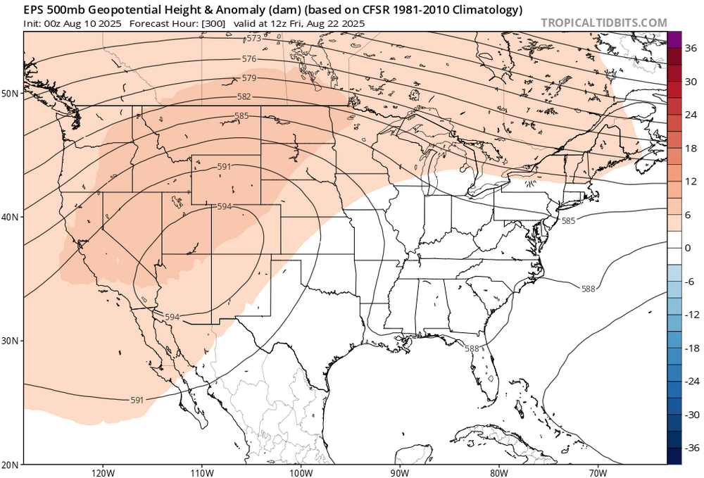
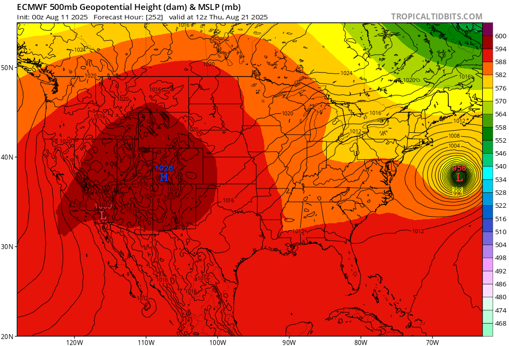
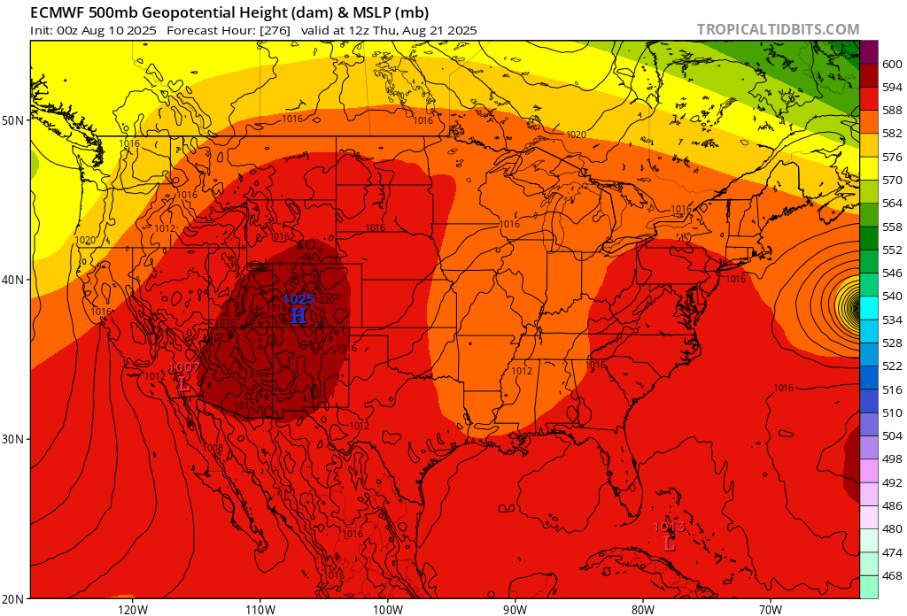
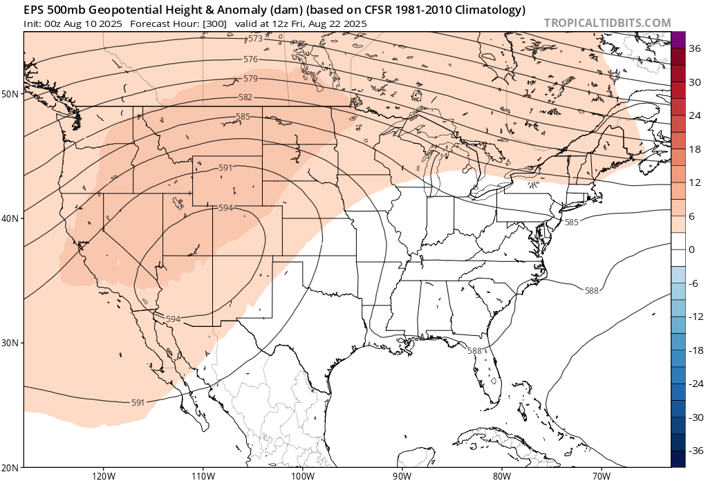
Nice improvements in the temperature department on the 0z runs. The models get Erica back to near 70W off the Carolinas. So it erodes the ridge and lowers the 500mb heights. This causes the current warm pattern to end by early next week.
Tropical systems are often the wild card for us after mid-August heatwaves. They can stay offshore like the current guidance shows and still weaken the WAR or Southeast Ridge.
The new runs now have lower heights in the East in just 12 hours. So we need later runs to get the storm back near 70W for the relaxation of the heat to continue.
Remember, the long range pattern all summer has been to build heights higher than the original forecasts. But it often takes a tropical system to disrupt heat patterns along the East Coast this time of year.
New runs have Erica weakening the ridge into the long range

Old run kept the heat going into next week
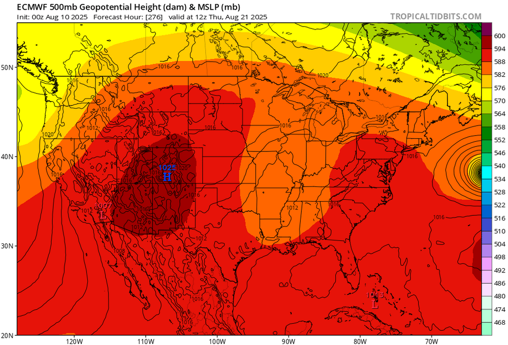
Late August ridge weakened in just one run. Will it hold for later runs? Stay tuned…
New run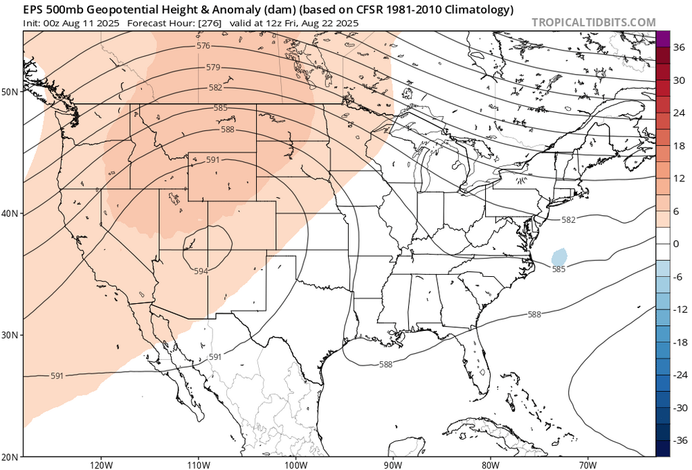
Old run
Erica? Isn’t the next named system Erin in the Atlantic.
-
2
-
-
89.0 in Muttontown and 88.4 in Syosset for the highs. Not much above forecast this morning which was 87, as I recall.
-
21 minutes ago, Sundog said:
The air is different today. Humidity up, heat is higher. Already 80 here with a dewpoint creeping up now just into the 60s.
We have entered our crappier weather period.
Doesn’t feel bad outside yet. DP still in the 50s. Probably had the last morning low in the 50s for a while though, 58 in Syosset and 59 in Muttontown.
-
 1
1
-
-
53 in Muttontown & 54 in Syosset this morning.
-
3
-
-
-
54 in Muttontown & 55 in Syosset this morning.
-
2
-
-
19 minutes ago, etudiant said:
Please add the link, if possible.
-
56 in Muttontown & 57 in Syosset for the morning lows.
-
1
-
-
-
36 minutes ago, guinness77 said:
FYI for any Port Wash commuters: don’t expect service to return until after the PM rush. Sorry, don’t shoot the messenger.
That sucks for commuters wanting to get home. On to the main line with pickup at New Hyde Park station for those around Great Neck area.
-
2
-
-
4 minutes ago, guinness77 said:
Transit alert for you: Port Wash branch suspended and Clearview and CI both shut down and LIE at Springfield Blvd. I don’t have the pix, but the water is completely above the 3rd rail at Bayside station.
Yep, 3:26 they suspended the Pt Washington line for high water E of Flushing Main St. Got the text alert from the MTA at that time.
-
40 minutes ago, WestBabylonWeather said:
Northern Nassau border queens looks interesting
It's just a non stop deluge currently. Have water leaking in one of our office suites too from the window.
-
1
-

August 2025 Discussion-OBS - cooler than normal first week but a big comeback to warmer than normal for the last 2-3 weeks
in New York City Metro
Posted