

uofmiami
-
Posts
1,650 -
Joined
-
Last visited
Content Type
Profiles
Blogs
Forums
American Weather
Media Demo
Store
Gallery
Posts posted by uofmiami
-
-
1 hour ago, bluewave said:
Look on the bright side. At least the heavy rain potential next week will wash away all the leftover salt on the paved surfaces. But make sure you have rain gutters with leaf guards.
")
Just had my gutters cleaned out today, bring on the rain!
-
2” in Syosset this morning.
-
 1
1
-
-
36 minutes ago, jm1220 said:
Getting windier here, trees are shaking pretty good. The ice/snow from earlier is all melted now. The dividing line for that here seemed to be around the LIE/Northern State. I drove from Long Beach this afternoon in rain/some sleet, then around Garden City the ground started to whiten. By Jericho Turnpike in Syosset it was half snow/sleet mix and the roads/ground were covered. Streets were horrendous when it was coming down.
Yeah my street was bad around 4:20pm heading to get food for the family. Once on main streets it was fine just had to be careful of slush on turning lane on Jericho tpke. Winds roaring with gusts to 30 here so far.
-
Snow flipped to sleet here in Syosset.
-
1
-
-
Not sure if anyone posted this but OKX radar is down starting 12/3 for an upgrade.
https://www.weather.gov/okx/SLEP-KOKX-December
Beginning December 3, 2019, the KOKX WSR-88D radar operated by the NOAA National Weather Service in Upton, New York will be down for approximately five days for the refurbishment of the transmitter. Although the form, fit, and function of the transmitter will remain the same, old breakers and cables original to the radar will be replaced with modern fuses and new cables. This will help keep the radar operating smoothly for another 20 years.
This transmitter update is the second major project of the NEXRAD Service Life Extension Program, a series of upgrades and replacements that will keep our nation’s radars viable into the 2030’s. NOAA National Weather Service, the United States Air Force, and the Federal Aviation Administration are investing $150 million in the seven year program. The first project was the installation of the new signal processor. The two remaining projects are the refurbishment of the pedestal and equipment shelters. The Service Life Extension Program will complete in 2022.
-
1
-
 1
1
-
2 minutes ago, NYCweatherNOW said:
I think these models are overdoing the warmth, and the fact that every time these models are too warm, nam seems to be much better in thermals I’d like to see that in the next day or two. I think we’re going to get a lot of snow out of this and even in the city could get a foot cause of the prolonging snows!

-
1
-
1
-
 2
2
-
-
20.9 in Syosset & 19.5 in Muttontown for the low this morning.
-
1
-
-
-
47 minutes ago, 495weatherguy said:
Would it be possible for you to post the yearly totals by month from 1970 to 1996?
https://www.weather.gov/media/okx/Climate/CentralPark/monthlyseasonalsnowfall.pdf
-
1
-
-
30.1 in Syosset and 29.8 in Muttontown. Nice bust by OKX on the temp forecast. Still never had a frost advisory or freeze warning issued, yet I’ve had lots of frost and a freeze.
-
1
-
-
35 minutes ago, psv88 said:
Forecast low is 38 and it’s currently 39...
Mine is 39 and I’m 37 already. I’m sure we’ll see 32 or lower in the morning.
-
3 hours ago, psv88 said:
33.3 this morning. Much colder than forecast. Radiated very well the past few nights
Always go lower than OKX with low winds and clear skies. They’ve busted badly the last couple of nights here in NE Nassau. I’m sure you’ve had the same for your location as well.
-
1
-
-
34.1 in Syosset and 31.9 in Muttontown this morning.
-
1
-
-
32.4 in Syosset and 30.7 in Muttontown this morning.
-
Gusting between 30-40 mph here in Syosset consistently.
-
7 minutes ago, Brian5671 said:
I was talking about Halloween-I'll edit my post to make it clearer
Ah, gotcha. Yes for Halloween I agree on your statement.
-
20 minutes ago, Brian5671 said:
euro is is very different a bit unsettled but minimal amounts of rain
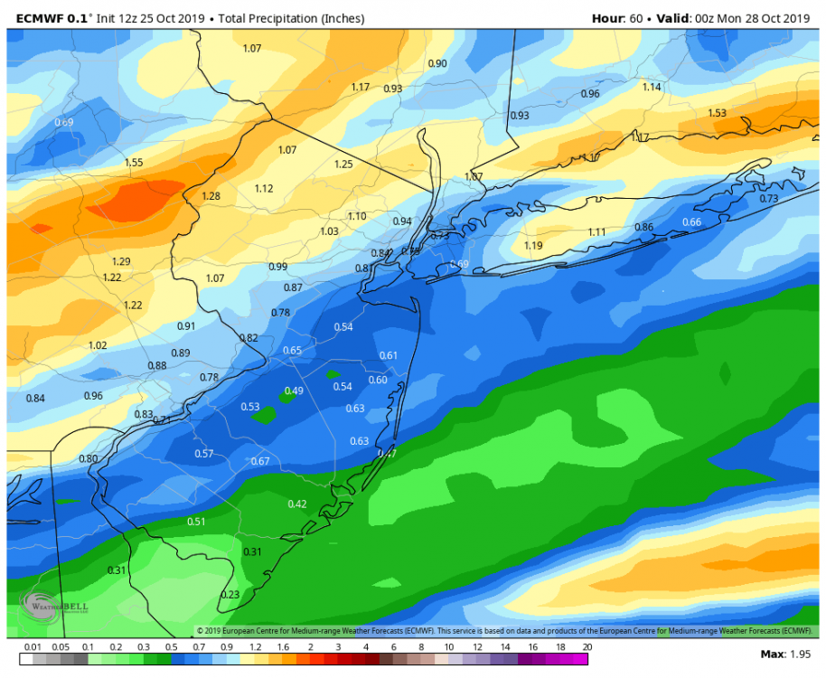
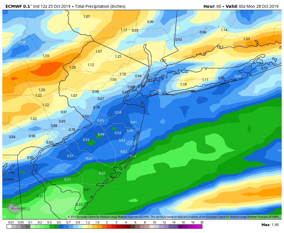
I wouldn't call the precip amounts minimal on the 12Z Euro. Has .50" to 1.75" depending on location.
-
2 minutes ago, bluewave said:
This persistent -PNA pattern resulted in a big shift west for the Pacific SST warm blob. It moved from near California to the Aleutians and weakened a bit since Labor Day. This reflects a pattern with only transient cool downs before the SE Ridge reloads.


Just like summer. We’d see the heat and it would get here for a little and then we’d get a transient shot of relief before the high DPs came back and the heat tried to get up to us. Then we’d repeat it all over again.
-
1 hour ago, purduewx80 said:
That number is biased towards climo that far out, but more importantly, the FV3 has been horrendous w the extended this fall. Should see those numbers creep up closer to the 60s-70s the Euro has been showing ~10/30-11/1. Still can’t rule out a backdoor front cooling things down but I suspect the SE ridge means business.
Oh I know the GFS is bad on the extended I was just showing there was guidance at the time showing 52. Hence the talk of cold happening. It’s already up to 57 now on 00Z run and as you said it’ll be in the 60s in no time. This SE ridge isn’t going anywhere, Miami is having its hottest October on record.
-
2 hours ago, CIK62 said:
F L A S H F L A S H F L A S H F L A S H FLASH FLASH
If not mentioned elsewhere, KWO-35 162.55Mhz. is back on the air. The hiatus was a typical governmental one of 23 months.
Transmitter Details Just got this- 6:52pm from site-, so maybe they are only testing.
Call Sign Power Frequency Status KWO35 1000 W 162.550 MHz OUT OF SERVICE https://nwschat.weather.gov/p.php?pid=201910231552-KOKX-NOUS41-PNSOKX
PUBLIC INFORMATION STATEMENT
NATIONAL WEATHER SERVICE NEW YORK NY
1152 AM EDT WED OCT 23 2019

...THE NOAA WEATHER RADIO NYC TRANSMITTER KWO-35 WILL BE ON THE
AIR FOR A FEW WEEKS TO TEST TRANSMISSION...

NOAA WEATHER RADIO STATION KWO-35, OPERATING ON A FREQUENCY OF
162.550 MHZ BASED OUT OF NEW YORK CITY, WILL BE ON THE AIR
FOR A FEW WEEKS TO TEST TRANSMISSION FROM A NEW LOCATION.

THE TRANSMITTER WILL BE OPERATING AT REDUCED POWER FOR THIS TEST
SO AREAL COVERAGE OF THESE BROADCASTS WILL BE OPERATING IN A
LIMITED CAPACITY. ONCE THESE TESTS ARE CONCLUDED AND DEEMED
SUCCESSFUL, WE WILL CONTINUE TO WORK TOWARDS A FULL OPERATION AND
PERMANENT INSTALLATION. FURTHER INFORMATION ON AN ESTIMATED TIME
OF RETURN TO SERVICE WILL BE PROVIDED ONCE THE TESTS HAVE BEEN
CONCLUDED THROUGH PUBLIC INFORMATION STATEMENTS.
-
1 minute ago, nycwinter said:
the normal high for the last day of october in nyc is 59 degrees enough with the cold air nonsense..
GFSX MOS has a high of 52 for 10/31 for NYC, but enough with the cold air nonsense.
-
1 minute ago, LibertyBell said:
I saw FOK was below freezing again. The skies were crystal clear this morning! Makes the fall foliage look extra brilliant
")
Yeah I saw 30 at 5am I bet they dropped to upper 20s this morning out there.
-
1
-
-
37.8 in Syosset and 37.4 in Muttontown this morning.
-
1
-
-
34.8 in Syosset & 33.5 in Muttontown this morning. Cars frosted up and frost on grass as well in Syosset.
December 2019
in New York City Metro
Posted
17.5 in Muttontown & 18.2 in Syosset for the low.