

uofmiami
-
Posts
1,647 -
Joined
-
Last visited
Content Type
Profiles
Blogs
Forums
American Weather
Media Demo
Store
Gallery
Posts posted by uofmiami
-
-
1 minute ago, Isotherm said:
Same here. 96.3F. Very hot/oppressive day. Tomorrow has potential to be slightly hotter with a higher launch pad.
I figured you were a lock for around 98 with your morning temps. Agree on tomorrow, as long as the clouds don’t put a damper on the sunshine.
-
93 here at 6pm.
-
-
Looks like 96 is my high for the day.
-
38 minutes ago, psv88 said:
Very rare for temp to keep rising here at 3 pm. 97.9 and my sensor is in the shade
My high temp is usually around 4pm for my location I have noticed. I get a slight drop 2-3 timeframe and then it rises back up until a tad after 4pm. Probably due to seabreeze clouds imo.
-
-
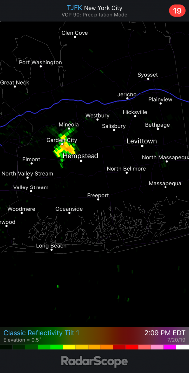
5 minutes ago, uofmiami said:
Something is popping by garden city on OKX radar it appears. Have to see if that develops and moves along boundary.
Popped up on jfk radar too:
-
4 minutes ago, psv88 said:
seabreeze about to roll in. This should do it for LI
Something is popping by garden city on OKX radar it appears. Have to see if that develops and moves along boundary.
-
9 minutes ago, psv88 said:
95/80 here
95/79 HI 112
-
10 minutes ago, psv88 said:
95/80/118 now. Unreal
I’m catching up. 94/78 HI 110 now.
-
9 minutes ago, uofmiami said:
92/79 HI 110
93/79 HI 111 now
-
-
-
6 minutes ago, psv88 said:
My neighbor placed his oscillating sprinkler next to the fence and it’s spraying my pws. Incredible. Never happened before lol.
That'll get you some evaporational cooling on your temps

-
9 minutes ago, psv88 said:
Even FRG is 88 lol. As is westhampton
I’m up to 87.3. No worries here.
-
11 minutes ago, psv88 said:
Wow, really lagging today. Even ISP at 90 now
Slow and steady for me, it’s ok. I’ll get up there today in temp.
-
85.5/76, HI 96. Low of 77 only. Going to cook today it seems.
-
18 minutes ago, pazzo83 said:
sacrus can correct me but isn't LGA's record high min 86? wonder if we break that this weekend
DC and Central Park I believe it's 84 - that could be challenged too (not tonight, but maybe tomorrow night).The following are records for this weekend: Record highest minimum temperatures for Saturday, July 20: NYC: 82 in 2015 LGA: 83 in 2015 JFK: 79 in 2015 EWR: 80 in 2015 ISP: 78 in 2013 BDR: 79 in 2013 Record high temperatures for Saturday, July 20: NYC: 101 in 1980 LGA: 101 in 1991 JFK: 96 in 2013 (Also occurred in previous years) EWR: 101 in 1980 ISP: 97 in 1991 BDR: 95 in 1001 Record highest minimum temperatures for Sunday, July 21: NYC: 82 in 1980 LGA: 83 in 1980 JFK: 79 in 2017 EWR: 81 in 1980 ISP: 76 in 1980 BDR: 76 in 1994 Record high temperatures for Sunday, July 21: NYC: 104 in 1977 LGA: 100 in 1991 JFK: 99 in 1991 EWR: 103 in 2011 ISP: 101 in 1991 BDR: 98 in 1991
-
4 minutes ago, doncat said:
93/ 77... Looks like 93 will do it for high after 70 am low temp.
Not enough sunshine further east to get to 90. Finished with a high of 87.4 for the day.
-
3 minutes ago, psv88 said:
Really socked in today, late day highs for sure. only 74 out here
We’ll probably takeoff around 10:30 or so once clouds are gone. 74.6 now
-
1 minute ago, IrishRob17 said:
Which is why I said bet the under two days ago...not that my Irish arse would be able to fell the difference of an 80 dew vs mid 80s
Literally splitting hairs, I don't think most care if it's close to 80 DP or low 80s DP, it's going to feel muggy regardless for the public.
-
9 minutes ago, Isotherm said:
93.2F/79F, HI 113 here! The dew point may be slightly high, but possibly not. Mesonet site Holmdel is recording a 78F dew point right now.
I’m always of the mindset the Davis sensors don’t accurately do DP and are off a tad. I’ve noticed the DP stays high longer after the end of precipitation events especially.
-
 1
1
-
-
Got a cell popping to the N it appears in Melville. Had a couple claps of thunder but that’s it so far.
-
94/78 HI of 112.
I’m dying in Melville outside.
-
1
-

July 2019 General Discussions & Observations Thread
in New York City Metro
Posted
90 now at 7:15. Temps are really slow to fall even on the island.