stormy
-
Posts
1,991 -
Joined
-
Last visited
Content Type
Profiles
Blogs
Forums
American Weather
Media Demo
Store
Gallery
Everything posted by stormy
-
The Valley hails with .01" over the weekend............ Here comes the drought again. Hey, fall is right around the corner. The NAM 3k gives me 39 degrees Wednesday morning!!!!!!
-
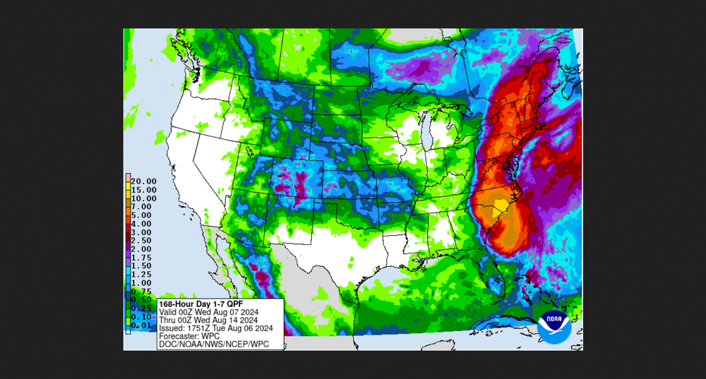
Latest WPC expected rainfall for the next 7 days from 1800z . Less than a quarter inch for western regions. 50" - .75" for eastern regions.
-
Sterling says the coming week will feel more like late September!
-
The latest NAM packages leave the Valley out while drenching D.C.. More of a 2 year pattern.
-
Every year, we gather in the fall to throw darts at the winter. This is entertaining and somewhat hilarious Other than a trivial distraction, interest is limited. Real Deal analogs are based on historical data............... I will provide some of this before Nov. 1.......
-
55 this morning
-
Expecting a low of 54 tonight. Nice
-
5.64" total. Wintergreen reported 9.08"
-
I think I have brainstormed the problem with a little help from the SPC. There has been a slight ridge wedging down the Valley from the northeast and discouraging rainfall moving in from the southeast. It is breaking down and should allow significant periods of rain to move in during the next several hrs. I have my fingers and toes crossed!! First real shower gave me .06 during the past 20 minutes.
-
The outer rainfall perimeter from Debby has been 5 - 10 miles southeast of my location for 3 hours!
-
.85" last 18 hrs. NHC now projects bullseye at Staunton at 6 am. New Market at 8 am. Outer perimeter of rain-shield 5 miles southeast.
-
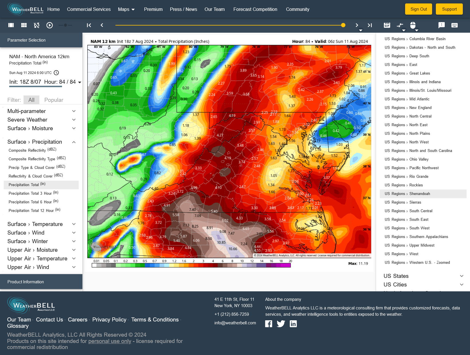
18z NAM , 4.19" Augusta.................... 1.56" D.C........................

-
NHC slows a little at 5 pm and shifts east slightly. Now near Charlottesville at noon Friday. The slowing I can understand based on current. The shift in track is probably not a conscious shift.
-
The NAM and ECMWF are both bouncing around quite a bit with the position of the center as the remnants move north across Va/WVa. The GFS and GEM are most consistent with the NHC up the Shenandoah Valley. Makes no difference, if the NHC general track verifies it will be wonderful! That would give western areas suffering tremendously from drought a multi-million dollar rain. Many millions of dollars worth of crops have already been lost. This will indeed be a God-Send for starving livestock who are also having water hauled in to them daily because ponds and streams that normally supply water are dried up. Hopefully, this will signal a change in the long term pattern.
-
NHC speeds up even more and shifts slightly west. Now, near Staunton at 8 am Friday.
-
12z NAM 12 increases my total from 2.71" to 3.62".

-
My NBM total expectation has dropped from 4.73" at 8 pm to 3.84" now with a similar track close to my area. One possible factor is the NHC expected acceleration of the storm if this is modeled. The NHC expectation is now around 25mph as it moves north across Virginia.
-
NHC shifts the track 13 miles east at 5 am to Charlottesville at noon Friday. This is good because I was afraid the westward jog would continue. Ridge east and trough west will turn the trick.
-
Crozet at noon Friday from NHC which is 13 miles west of Charlottesville. 14 miles east of my east side deck with the Blue Ridge in the middle. Upslope enhancement should give 5 - 10 inches along the B.R. 3 - 6 inches in my back yard.
-
The WPC shifts the axis of heaviest rain to the west:
-
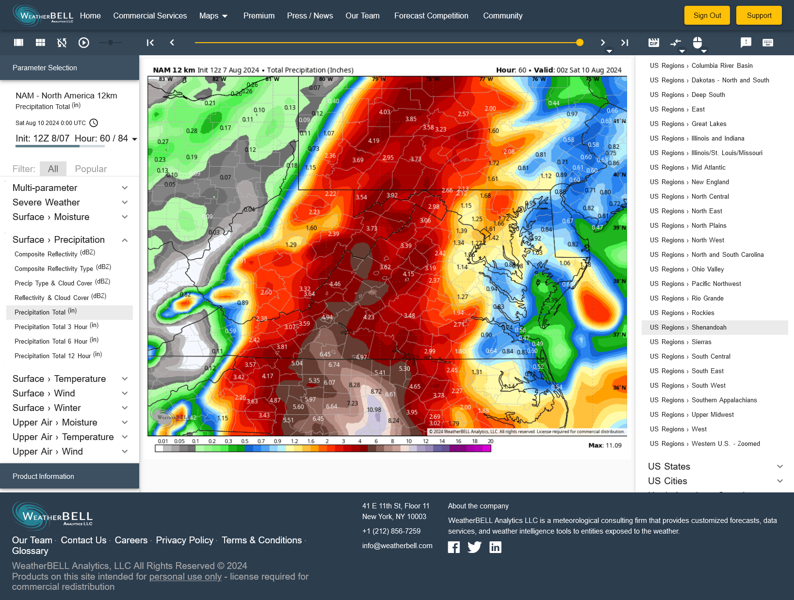
NAM 12 shifts west with 12z. Increased flood risk for western zones.
-
NHC shifts predicted track west overnight. 25 miles west of Richmond at midnight Friday. 20 miles southeast D.C. 2 am Saturday. My 3 model blend has increased from 3.76" at 6 pm to 4.96" at 7 am.
-
Some wonder about this model or that model???? That is nonsense. No model has the final solution yet. If they did it would be by pure accident.
-
The main question for the next 72 hrs. is exactly when and how strong will a mid level ridge build to the east of Debby. The strength of this ridge will determine whether Norfolk or Lynchburg will receive heavy rain.
-
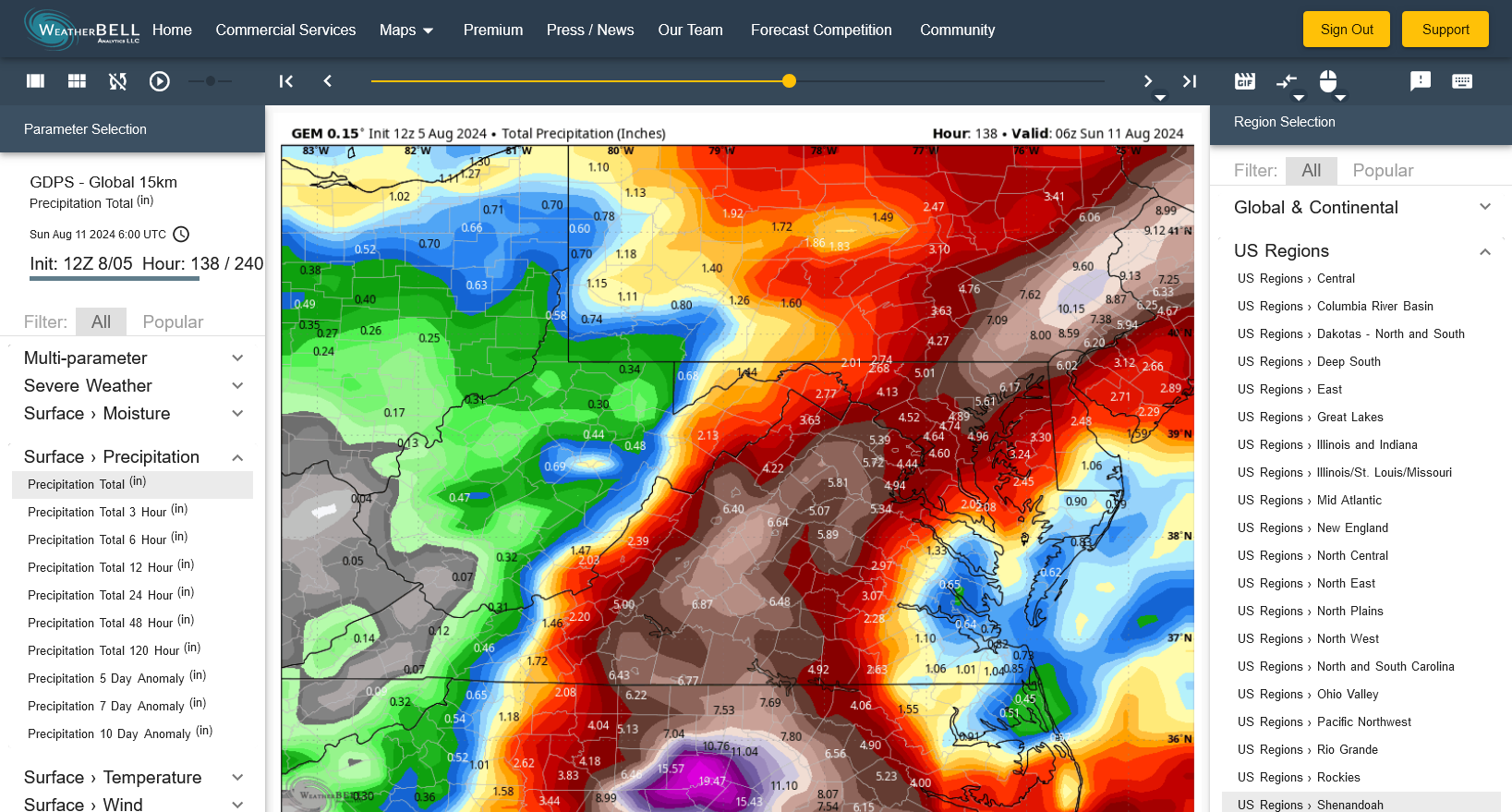
Latest GEM gives me nearly 7 inches! Bring it on!!!!!!! My stream needs a good flushing. It has been nearly 5 years.