

PhiEaglesfan712
-
Posts
1,411 -
Joined
-
Last visited
Content Type
Profiles
Blogs
Forums
American Weather
Media Demo
Store
Gallery
Everything posted by PhiEaglesfan712
-
2025-2026 ENSO
PhiEaglesfan712 replied to 40/70 Benchmark's topic in Weather Forecasting and Discussion
I'd say starting with the 16-17 winter. The last real ubiquitous snowstorm was the January 22-23, 2016 event. Even when we had that great 17-18 winter, the storms were capped at 8 inches at PHL and 10 inches at NYC. The only one since the 2016 snowstorm that went over those thresholds in NYC is the late January/early February 2021 snowstorm, and even that one didn't do well in coastal areas. (The January 28-29, 2022 snowstorm did well in the coastal areas, not so much west of 95.) Something happened after the super el nino that's capping the potential for a ubiquitous snowstorm. -
2025-2026 ENSO
PhiEaglesfan712 replied to 40/70 Benchmark's topic in Weather Forecasting and Discussion
Believe it or not, 1983 is already below average (compared to 1981-2010 and 1991-2020). 1999 is slightly above average on 1991-2020 (it will be close on whether it stays above 2001-2030). -
2025-2026 ENSO
PhiEaglesfan712 replied to 40/70 Benchmark's topic in Weather Forecasting and Discussion
Summers at PHL since 2010: Colder than the 1981-2010 average: 2014, 2023 (although this one ends above average if we use JAS instead of JJA) Warmer than the 1981-2010 average, but colder than the 1991-2020 average: 2013, 2017 Warmer than the 1991-2020 average: all other years (2010-2012, 2015, 2016, 2018-2022, 2024) Looking ahead, it looks like 2018 (which is only 0.2 degrees above the 1991-2020 average) will fall below the 2001-2030 average. Along with years like 2001, 2006, and 2008, which were at the time Top 10 warmest summers on record. -
E PA/NJ/DE Summer 2025 Obs/Discussion
PhiEaglesfan712 replied to Hurricane Agnes's topic in Philadelphia Region
New record high of 98 set at PHL. This leaves July 12 (my birthday) as the only July day at PHL to not have a record high of at least 98. -
2025-2026 ENSO
PhiEaglesfan712 replied to 40/70 Benchmark's topic in Weather Forecasting and Discussion
Yeah, I like knew in mid-June this was going to be a low ACE season (and it's pretty funny this is happening on the 20th anniversary of the most active season ever). A 2013-type season with just TS/C1 storms is looking more and more likely with each passing day. -
2025-2026 ENSO
PhiEaglesfan712 replied to 40/70 Benchmark's topic in Weather Forecasting and Discussion
Yeah, that snowstorm brought us the LeSean McCoy snow game against the Lions, as well as the crazy ending of the Vikings-Ravens game in Baltimore. The first half of that December was great. The 2nd half of December was the thaw period of that winter. Once the calendar flipped to January, the winter ramped up and didn't really let up until the end of March/beginning of April. -
2025-2026 ENSO
PhiEaglesfan712 replied to 40/70 Benchmark's topic in Weather Forecasting and Discussion
13-14 and 14-15 were wall-to-wall winters, or at least very close. Both were very cold and snowy from at least January to March, with each having a cold November, and 13-14 a taste of winter in early December (before a 2nd half of the month thaw). 08-09 definitely felt like a longer winter than 09-10 and 10-11. It's just that the cold and snow didn't come hand-in-hand. The cold was there in October-January, but the two snow events happened in early February (this one was more isolated) and early March (the Nor'easter). Of course, 15-16 was saved by the massive snowstorm. Otherwise, it would have been another warm and snowless winter that has become more commonplace since 11-12. -
2025-2026 ENSO
PhiEaglesfan712 replied to 40/70 Benchmark's topic in Weather Forecasting and Discussion
The most amazing thing about that 7/8-year stretch from 08-09/09-10 to 15-16 is that we put up those snow totals despite having 2 years with virtually no snow in the middle. Imagine how much more those snow totals could have been if we got anything in 11-12 and 12-13. PHL could set a record for the lowest 10-year running average snowfall in 25-26. Anything less than 13.4 inches would break the record of 13.2 inches average from 1922-23 to 1931-32. -
2025-2026 ENSO
PhiEaglesfan712 replied to 40/70 Benchmark's topic in Weather Forecasting and Discussion
Looks like slightly above average: -
2025-2026 ENSO
PhiEaglesfan712 replied to 40/70 Benchmark's topic in Weather Forecasting and Discussion
Looks like a pattern change is coming as we begin August: Is a below average August temperature departure in the cards? -
2025-2026 ENSO
PhiEaglesfan712 replied to 40/70 Benchmark's topic in Weather Forecasting and Discussion
The most amazing thing about the winters of 2009-10 and 2010-11 is how that much snow fell in such a short window of time. The snow during those winters ended abruptly (although 2011 did have a small storm on President's Day and a last hurrah at the end of March). -
2025-2026 ENSO
PhiEaglesfan712 replied to 40/70 Benchmark's topic in Weather Forecasting and Discussion
Yeah, I really don't care about a record high temperature in Montana. It has no bearing on our area. There were a lot of record high temps in Montana during January, February, and March 2015. It's not going to take away from the fact that it was the coldest JFM since 1978 where I live. Or the fact that Montana had a +10 temp departure last December. Temps were near normal last December in my area, and it was the coldest winter of the last 10. -
2025-2026 ENSO
PhiEaglesfan712 replied to 40/70 Benchmark's topic in Weather Forecasting and Discussion
We haven't seen those types of temperatures here since January 1994 (and I was barely young enough to remember that). Before that, the last time it happened was in January 1985 (before I was born). We haven't had a legitimate cold shot in this area so far this decade. The last one was the end of January 2019. -
2025-2026 ENSO
PhiEaglesfan712 replied to 40/70 Benchmark's topic in Weather Forecasting and Discussion
I'll only take it if the sharp snow cutoff is somewhere south of PHL. 2007-08 and 2016-17 absolutely sucked for me. -
2025-2026 ENSO
PhiEaglesfan712 replied to 40/70 Benchmark's topic in Weather Forecasting and Discussion
Yeah, even without the blocking, we still had one final hurrah during the final third of March. 2011-03-23 40 32 36.0 -8.8 29 0 0.87 T 0 2011-03-24 44 30 37.0 -8.2 28 0 0.09 1.0 1 2011-03-25 42 28 35.0 -10.5 30 0 0.00 0.0 0 2011-03-26 40 26 33.0 -12.9 32 0 0.00 0.0 0 2011-03-27 45 28 36.5 -9.7 28 0 0.00 0.0 0 2011-03-28 45 26 35.5 -11.1 29 0 0.00 0.0 0 2011-03-29 49 31 40.0 -6.9 25 0 0.00 0.0 0 2011-03-30 53 36 44.5 -2.8 20 0 0.01 0.0 0 2011-03-31 43 37 40.0 -7.7 25 0 0.13 T 0 This turned a solid warm first two-thirds of the month into a negative departure. -
2025-2026 ENSO
PhiEaglesfan712 replied to 40/70 Benchmark's topic in Weather Forecasting and Discussion
As they say, the strongest el ninos are followed by a strong la nina. Such transitions happened in 1973, 1988, 1998, and 2010. Even in years when a strong el nino didn't transition into a strong la nina, strong el ninos are almost always followed by a la nina. 2024 is only the 2nd time (dating back to the 1972-73 super el nino event) that a strong el nino didn't immediately transition into a la nina (1992 was the other). A strong el nino following a strong la nina is pretty much unprecedented. Usually, there is a buffer year in between a strong la nina and a strong el nino (like 1956-57 and 2008-09). The only time an el nino immediately followed a strong la nina year was in 1976 (the year the PDO flipped from - to +). In short, a la nina event is more likely to run in a continuum (see 2020-23 triple la nina, which peak was almost the same each year). El ninos running in a continuum is very rare (the most recent one was the 1986-88 event). -
2025-2026 ENSO
PhiEaglesfan712 replied to 40/70 Benchmark's topic in Weather Forecasting and Discussion
I'm always surprised by the fact that the winter of 2010-11 didn't end up colder than the winter of 2009-10, especially considering that 10-11 was a strong la nina and 09-10 was a strong el nino. -
2025-2026 ENSO
PhiEaglesfan712 replied to 40/70 Benchmark's topic in Weather Forecasting and Discussion
The 80s warming didn't really happen after the 1982-83 el nino. I feel it more happened after the 1986-88 event. Global temps in 1982 and 83 weren't much higher than 80 or 81. It didn't really didn't break through until 1988. We were still getting below 0 temps at PHL in January 1984 and January 1985. After the 86-88 el nino, below 0 temps only happened once at PHL (1/19/1994). -
2025-2026 ENSO
PhiEaglesfan712 replied to 40/70 Benchmark's topic in Weather Forecasting and Discussion
The last 4" snowfall for NYC is still 1/28-29/2022, correct? Also interesting to note that if not for the late January/early February 2021 snowstorm, NYC would be working on nearly a decade since the last 10" snowfall. I remember someone saying that 2021-22 through 2024-25 joins 2016-17 through 2019-20 as the only 4-year periods without a 10-inch snowstorm. If that's the case, then if we don't get a 10-inch snowstorm this year, it will be the first 5-year period and 9 out of 10 years without a 10-inch snowstorm. -
2025-2026 ENSO
PhiEaglesfan712 replied to 40/70 Benchmark's topic in Weather Forecasting and Discussion
Of all those years listed, 2013-14 is probably the only one that's reasonable, as it really wasn't a +PDO winter. It generally moved toward a positive direction (neutral), but it was mostly a -PDO winter. In fact, I think it's a better analog than 1916-17 (it's hard to ignore the fact that global temps are ~2C warmer now than in 1916-17). I'm not saying that the PDO will make it all the way back to neutral by the time the winter is over (the big difference between now and 2013 is that the PDO is at -3 to -4 now, whereas the PDO was around -1.5 in the summer of 2013), but a -2 PDO at the start of winter and a -1 at the end is doable. But it's all going to depend on the WPAC jet. This winter has a high variance of outcomes. I can see a 2013-14 type winter happening, but by the same token, I could just as easily see a 2011-12 type winter (say the -PDO stays deeply negative, a la nina, and the WPAC staying the same). -
2025-2026 ENSO
PhiEaglesfan712 replied to 40/70 Benchmark's topic in Weather Forecasting and Discussion
1916-17 was one of the strongest la ninas of all time, on the level of years like 1973-74, 1988-89, and 2010-11. 1917 was when global temperatures were at their minimum (2024, the warmest year on record, was nearly 2C warmer than 1917). I'd be willing to bet that either 1916-17 or 1917-18 was the coldest winter on record CONUS. -
2025-2026 ENSO
PhiEaglesfan712 replied to 40/70 Benchmark's topic in Weather Forecasting and Discussion
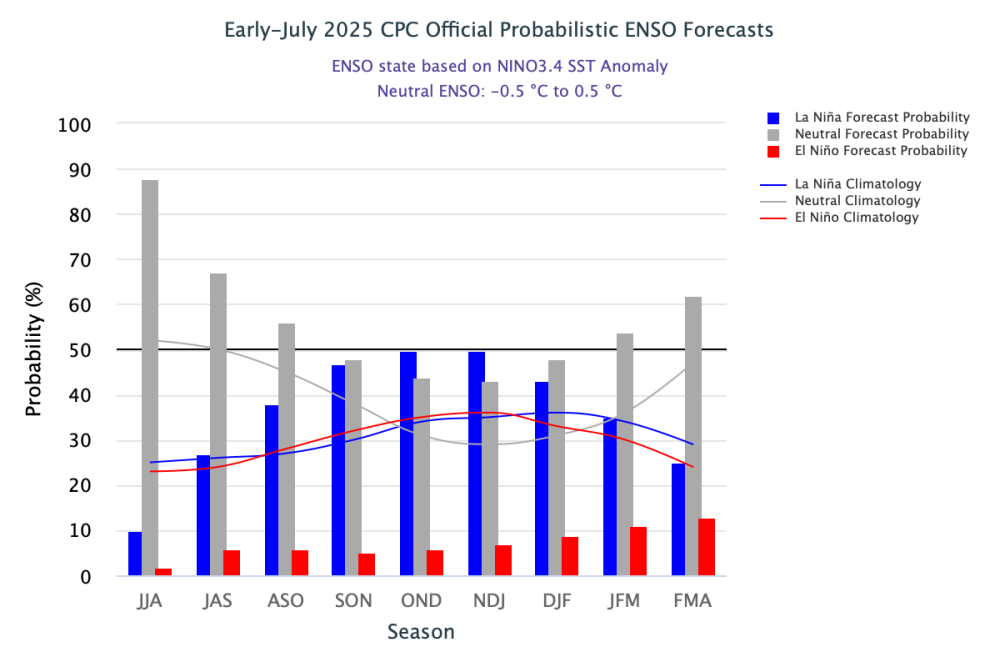
-
2025-2026 ENSO
PhiEaglesfan712 replied to 40/70 Benchmark's topic in Weather Forecasting and Discussion
Come to think of it, we really haven't really had an arctic outbreak in the mid-Atlantic/Northeast in the 2020s decade. The last one that could qualify as one was the one in late January 2019, but that was for about a few days. Before that, late December 2017/early January 2018. But the last real sustained arctic outbreak was 2015, which lasted for the greater part of 3 months (January-March). I still can't believe the Aetna lake in Medford, NJ was frozen in late February/early March. -
2025-2026 ENSO
PhiEaglesfan712 replied to 40/70 Benchmark's topic in Weather Forecasting and Discussion
The Nino 1+2 has been in an el nino for pretty much the last 2 years, ever since the 2023-24 strong el nino started in the summer of 2023. If we were to get a strong or super el nino in ENSO 3.4, the Nino 1+2 is going to really go off the chart like in 1982-83 and 1997-98. -
2025-2026 ENSO
PhiEaglesfan712 replied to 40/70 Benchmark's topic in Weather Forecasting and Discussion
Yeah, they need to like cut that 140 ACE in half. It's shaping up to be a low activity season, like 2013 and 2014. This was my forecast in mid-June: 11 named storms (range 8-14) 4 hurricanes (range 2-6) 1 major hurricane (range 0-2) 51.5 ACE (range 36-67)
