JenkinsJinkies
-
Posts
1,553 -
Joined
-
Last visited
Content Type
Profiles
Blogs
Forums
American Weather
Media Demo
Store
Gallery
Everything posted by JenkinsJinkies
-
The severe forecasts north of Anne Arundel County have been more hit than miss this year.
-

Late May/June 2026 Medium/Long Range
JenkinsJinkies replied to JenkinsJinkies's topic in Mid Atlantic
Check if the thermohaline circulation has weakened recently. A similar occurrence in 2013 was caused by it. -
Late May/June 2026 Medium/Long Range
JenkinsJinkies replied to JenkinsJinkies's topic in Mid Atlantic
There was a look on some of the reliable models of the storms ushering in a pattern change. It’s just that after the storm hit it got can kicked and then collapsed. I addressed that in a follow up thread. -
Late May/June 2026 Medium/Long Range
JenkinsJinkies replied to JenkinsJinkies's topic in Mid Atlantic
I changed the tags the other day, maybe replace the first part of a variation of that. I would’ve done so if I had the ability to.- 144 replies
-
- 1
-

-
- we got burned
- rugpull central
- (and 1 more)
-
The thing is will that change stick or be yet another one off?
-
Therein lies the rub, there's been ample opportunities for that to break down these last 3 years but when that opportunity arises the nw flow abruptly injects steroids or if it is beaten back it's only fleeting and it comes roaring back in as little as a few days. A niño should be able to overcome that but like in 2023 we're instead dealing with winter style futility until we're well past the summer solstice.
-
Okay seriously, we got burned by another head fake. The forecast for the Memorial Day soaker didn’t disappoint for the first time in ages, and in the week leading up to it the models did show it ushering in a wet pattern. Yet when the system ran its course the follow up rain events were can kicked an additional week and are now in the process of collapsing. Since 2023 we’ve get these big rain events that happen roughly 6 months apart which mathematically should usher in a wet pattern but every time said pattern fails to materialize despite the storm verifying. Did something else break in the atmosphere to make things permanently drier? It’s not supposed to be this hard to get a wet pattern here.
-
Late May/June 2026 Medium/Long Range
JenkinsJinkies replied to JenkinsJinkies's topic in Mid Atlantic
-
Late May/June 2026 Medium/Long Range
JenkinsJinkies replied to JenkinsJinkies's topic in Mid Atlantic
https://x.com/scweather_wx/status/2061545870441824660?s=46- 144 replies
-
- 1
-

-
- we got burned
- rugpull central
- (and 1 more)
-
Late May/June 2026 Medium/Long Range
JenkinsJinkies replied to JenkinsJinkies's topic in Mid Atlantic
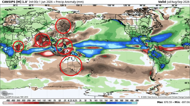
Cansips has it turning wet, though that's a seasonal forecast. -
Late May/June 2026 Medium/Long Range
JenkinsJinkies replied to JenkinsJinkies's topic in Mid Atlantic
Cansips has it too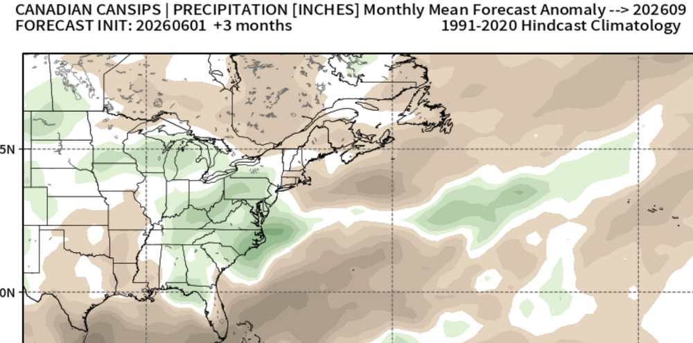
-
Late May/June 2026 Medium/Long Range
JenkinsJinkies replied to JenkinsJinkies's topic in Mid Atlantic
-
Late May/June 2026 Medium/Long Range
JenkinsJinkies replied to JenkinsJinkies's topic in Mid Atlantic
There must be a localized force field for you. My first storm was in March. -
Do you want Ellicott City to flood again? Because that how Ellicott City floods again.
-
Late May/June 2026 Medium/Long Range
JenkinsJinkies replied to JenkinsJinkies's topic in Mid Atlantic
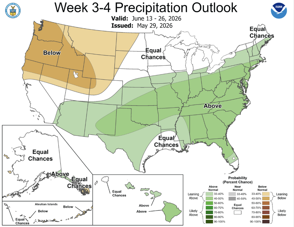
It's looking like it's lasting a week max. -
Watch the rain come back the week after that.
-
Late May/June 2026 Medium/Long Range
JenkinsJinkies replied to JenkinsJinkies's topic in Mid Atlantic
Why do I get the feeling that this was yet another one off that tricked us into thinking it’s the start of a sustained wet pattern… Then again those dry maps stop mid next week and it’s just a relax before a reload. -
Late May/June 2026 Medium/Long Range
JenkinsJinkies replied to JenkinsJinkies's topic in Mid Atlantic
The last time we had a super niño it was over 70 degrees on Christmas Eve.- 144 replies
-
- 1
-

-
- we got burned
- rugpull central
- (and 1 more)
-
Late May/June 2026 Medium/Long Range
JenkinsJinkies replied to JenkinsJinkies's topic in Mid Atlantic
For our region a vast majority of it given the 5 day forecast. For the south I can’t answer that. -
Late May/June 2026 Medium/Long Range
JenkinsJinkies replied to JenkinsJinkies's topic in Mid Atlantic
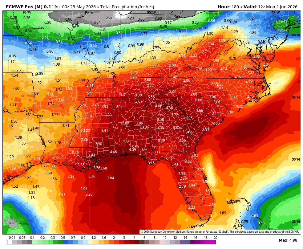
Looks like another inch or so this week. Looking at the south it seems like the STJ is finally back.
-
There’s barely any restriction though, it’s all voluntary.
-
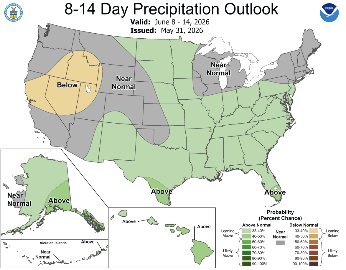
The pattern finally changed, drought will be in the rear view mirror by the end of Summer.
-
It’s just getting started.
-
I don't buy it.