

Powerball
-
Posts
14,420 -
Joined
-
Last visited
Content Type
Profiles
Blogs
Forums
American Weather
Media Demo
Store
Gallery
Everything posted by Powerball
-
Can't help but chuckle at the SPC They've been bouncing Dallas in and out of the Slight Risk area with every new outlook. Can't make up their minds, lol...
-
Yep. I'm never going back into the office if I can help it...
-
For sure to us big city folks.
-

Spring 2023 Medium/Long Range Discussion
Powerball replied to Chicago Storm's topic in Lakes/Ohio Valley
Too bad it'll melt before reaching the Mason-Dixon line... -
Spring 2023 Medium/Long Range Discussion
Powerball replied to Chicago Storm's topic in Lakes/Ohio Valley
Hoping the current long range peojections don't pull on Lucy on you all (it's happened before). -
The root of the issue is that people, by their nature, are mostly concerned about weather that may or may not impact their own backyard. If it happens elsewhere, then it's out of sight and out of mind. If one would like to see more discussion about weather in a specific location, then more people from that specific location have to join the forum & actively participate. That's the only solution, as no type of realignment with the subforums would fix the Viriginia Beach and West Palm Beach examples you shared.
-
Imagine getting 3 feet of snow in May...
-
The NAO/AO/PNA are all projected to trend towards neutral as well. Obviously, this all will make more of a difference the further SW one is, with respect to the extent of warmth.
-
The NWS recognizes Heat Lightning as a way to describe it. So as I said, Heat Lightning. https://www.weather.gov/safety/lightning-heat#:~:text=The term heat lightning is,to hear the accompanying thunder.
-
Texas/Oklahoma Discussion & Obs Thread 2022
Powerball replied to It's Always Sunny's topic in Central/Western States
Now this is more like it!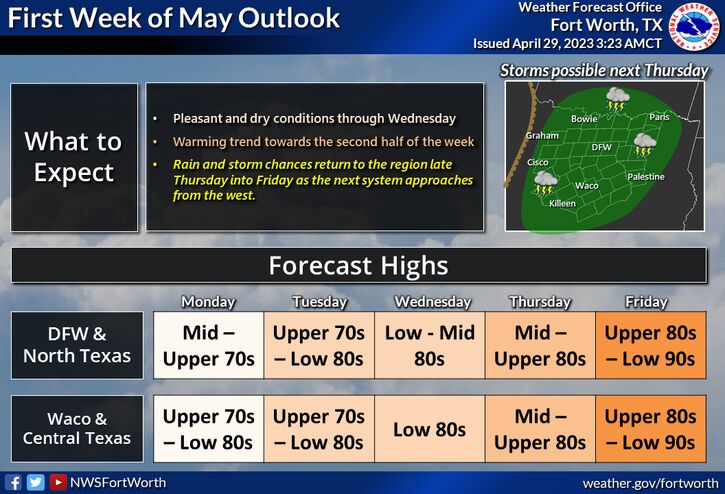
-
The heat lightning on Summer nights in Florida is definitely the best. There was an event in MI about 15-20 years ago (wanna say 2006-ish time frame?) that had awesome heat lightning too. Was seeing frequent lightning flashes in the cloud tops of storms that were hitting Saginaw from all the way on Detroit's east side. Then headed into the evening and after sunset, it was non-stop flashes to the west and NW as storms gradually moved in from SW Michigan (they did weaken before reaching the city though).
-
Severe Weather 4-25 through 4-28-23
Powerball replied to cheese007's topic in Central/Western States
That's because there really isn't anyone on here from San Antonio or Houston. You're the only one that posts regularly. Everyone else is from North Texas. -
Wow! I figured you were older than 37... And sorry to hear about the surgeries and body aches. That's pretty young to have back problems to such an extent.
-
Severe Weather 4-25 through 4-28-23
Powerball replied to cheese007's topic in Central/Western States
Just as I figured, that's exactly how it's evolving. -
Severe Weather 4-25 through 4-28-23
Powerball replied to cheese007's topic in Central/Western States
My suspicion is that tomorrow will be a repeat of the past 2 events, in that the best potential ends up just SE of DFW. These shortwaves have a tendency to end up less compact (thus the fronts also move through faster) once we're in the range for CAMs. Besides, this is one of those setups where while there might be better daytime heating, moisture will be more limited and it will take the entire balance of the day to break the cap for widespread activity (the front is currently proejcted to move through mid-afternoon) Waco and Tyler have both been on a role this season though. -
Severe Weather 4-25 through 4-28-23
Powerball replied to cheese007's topic in Central/Western States
The fact that they say Central *AND* North Texas in their AFD is kind of misleading though. It's shaping up to be a mostly Central Texas day. -
Severe Weather 4-25 through 4-28-23
Powerball replied to cheese007's topic in Central/Western States
Today is definitely cooked for DFW. Down towards Waco is looking good. -
Severe Weather 4-25 through 4-28-23
Powerball replied to cheese007's topic in Central/Western States
Very messy radar/satellite right now. -
Severe Weather 4-25 through 4-28-23
Powerball replied to cheese007's topic in Central/Western States
^^^This post might end up aging like milk. Guessing that the SPC took off the original forecast (This was for the Tuesday forecast) due to it being more of a conditional threat. Then they decided to add it back to the forecast when they had more confidence in the forecast? Threat still reamins somewhat conditonal beacsue of the extensive cloud cover that will be expected and the weak LLJ, but it's a solid setup for flash flooding and large hail. -
For now, DTW's temperature departure for this April is still 3.4+ (albeit half of what it was just a week ago). Still plenty of time to go down further though.
-
Severe Weather 4-25 through 4-28-23
Powerball replied to cheese007's topic in Central/Western States
^^^This post might end up aging like milk. -
^^^The anti-Cromartie...
-
In addition, the atmospheric effects from Mount Pinatubo's eruption in June 1991 was delayed until the following Summer (1992)
-
All I see are articles discussing the possibility of an eruption at Yellowstone in the future. I thought there was one that had actually occurred.
-
What volcano eruption?


