Maggie Valley Steve
-
Posts
865 -
Joined
-
Last visited
Content Type
Profiles
Blogs
Forums
American Weather
Media Demo
Store
Gallery
Everything posted by Maggie Valley Steve
-

2025-2026 Fall/Winter Mountain Thread
Maggie Valley Steve replied to Buckethead's topic in Southeastern States
It sure is beginning to look like it's going to be a snowy 5 to 7 days around here. The GFS wants drop snow in 3 separate events!.thumb.png.790b7a474065eb423cab6deea002ab51.png)
-
2025-2026 Fall/Winter Mountain Thread
Maggie Valley Steve replied to Buckethead's topic in Southeastern States
Source: Peakbagger.com https://share.google/hKp2XlFoHugG7B0pL -
2025-2026 Fall/Winter Mountain Thread
Maggie Valley Steve replied to Buckethead's topic in Southeastern States
Sam's Gap lies on the border of Swain and Sevier Counties along the border. Sam's Gap is at 4775 ft with Big Chestnut Bald to the ESE and Mt Davis just to the WNW. -
2025-2026 Fall/Winter Mountain Thread
Maggie Valley Steve replied to Buckethead's topic in Southeastern States
Starting to see more indications that tomorrow afternoon into Thursday and even possibly extending into Friday morning we snow across the Mountains. It's beginning to look like we will get some Lake effect flow spilling over the Smokies. I would not be surprised to see totals increase overnight into the 12Z runs tomorrow. There also is a robust vort max that passed over Houston this afternoon bringing rain. That feature is currently over Louisiana headed generally this direction. -
2025-2026 Fall/Winter Mountain Thread
Maggie Valley Steve replied to Buckethead's topic in Southeastern States
GSP stated in their afternoon disco that snow totals have increased again. I'll be watching the shorter term guidance the next 24 hours. I did see some of the convection allowing models suggesting up to a foot of snow along the highest peaks. -
2025-2026 Fall/Winter Mountain Thread
Maggie Valley Steve replied to Buckethead's topic in Southeastern States
I see Morristown has issued a WWA starting tomorrow afternoon at 3PM along theborder. GSP is likely to follow this afternoon for the Border Counties. -
January 2026 Short/Medium Range Thread
Maggie Valley Steve replied to John1122's topic in Tennessee Valley
Pineapple Express was the name. That was long before the NOAA G-IV flew and long before the 53rd out of Kessler ventured out for Winter RECON missions! -
January 2026 Short/Medium Range Thread
Maggie Valley Steve replied to John1122's topic in Tennessee Valley
Back in the late 90s I would fly out from Houston to Reno to ski at the Lake Tahoe area slopes when the now named Atmospheric River events were showing up on the models! You can't go wrong in those events! -
Mid-Long Range Discussion 2026
Maggie Valley Steve replied to BooneWX's topic in Southeastern States
At least we aren't the Mid Atlantic! -
2025-2026 Fall/Winter Mountain Thread
Maggie Valley Steve replied to Buckethead's topic in Southeastern States
And additional flow snow chances into next week! We are getting some very cold shots throughout the next couple of weeks. There is really no reprieve from cold temperatures in the foreseeable future! We are in for an active period for at least the next couple of weeks in prime climatology! -
2025-2026 Fall/Winter Mountain Thread
Maggie Valley Steve replied to Buckethead's topic in Southeastern States
The models continued to advertise a shorter duration event ending early pre-dawn Thursday morning. That said, I see a trend developing that we start as snow Wednesday afternoon with no mixing issues from the point when the front arrives. Another point is the higher ratios due to the very cold temperatures immediately behind the Arctic front. -
2025-2026 Fall/Winter Mountain Thread
Maggie Valley Steve replied to Buckethead's topic in Southeastern States
18 for my low this morning. Still looking like and Advisory event Wednesday night and Thursday morning. I noticed the NAM models where a bit juicier overnight at the end of their runs. Next weekend is still worth monitoring. It's going to be very cold late this work week with windchill indices at or below zero! -
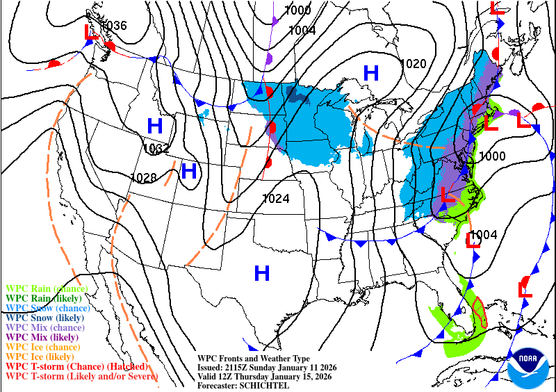
2025-2026 Fall/Winter Mountain Thread
Maggie Valley Steve replied to Buckethead's topic in Southeastern States
The WPC Updated afternoon surface charts for 12Z Wednesday and 12Z Thursday.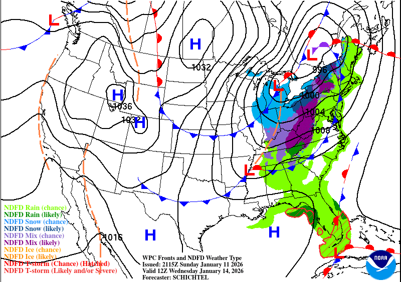
-
2025-2026 Fall/Winter Mountain Thread
Maggie Valley Steve replied to Buckethead's topic in Southeastern States
GSP in their afternoon disco suggest that we'll have a WWA event Wednesday night into Thursday for the Mountains. -
2025-2026 Fall/Winter Mountain Thread
Maggie Valley Steve replied to Buckethead's topic in Southeastern States
I am seeing a lot of positive trends in regards of the various computer schemes for the week ahead and even in the day 10 range. I'm seeing some potential for the Gulf upcoming as it is still very warm and capable of spinning up low pressure particularly along the NW and Central Gulf Coast. There is a decent stream of moisture from the Pacific heading our way along the Sub Tropical Jet. I'll be watching the Gulf carefully the next several days carefully. -
2025-2026 Fall/Winter Mountain Thread
Maggie Valley Steve replied to Buckethead's topic in Southeastern States
We are getting another snow shower in between breaks in the clouds. No accumulations and frankly I was a bit surprised that we would see snow today down to the Valley floor. Cataloochee is snowing and the snow guns are blowing! It should be a great week ahead for the ski areas with lots of opportunities to build back the snow pack! -
2025-2026 Fall/Winter Mountain Thread
Maggie Valley Steve replied to Buckethead's topic in Southeastern States
Actually, the Cabin got a 2 night booking Friday afternoon and added an additional night yesterday morning for MLK weekend! Fingers crossed the Guest Suite will book this week! -
2025-2026 Fall/Winter Mountain Thread
Maggie Valley Steve replied to Buckethead's topic in Southeastern States
Light snow in the Valley and roaring wind at times. -
2025-2026 Fall/Winter Mountain Thread
Maggie Valley Steve replied to Buckethead's topic in Southeastern States
Just emptied a bit over 2 inches from the gage. Looks like the heavier rain has shifted SE. -
2025-2026 Fall/Winter Mountain Thread
Maggie Valley Steve replied to Buckethead's topic in Southeastern States
Not too shabby of a trend through Thursday!.thumb.png.2e3c260503205a32c60559705ea29bf7.png)
-
2025-2026 Fall/Winter Mountain Thread
Maggie Valley Steve replied to Buckethead's topic in Southeastern States
I just had a clap of thunder! -
January 2026 Short/Medium Range Thread
Maggie Valley Steve replied to John1122's topic in Tennessee Valley
I'm praying for your Mom Powell. It's always tough when our parents are suffering. -
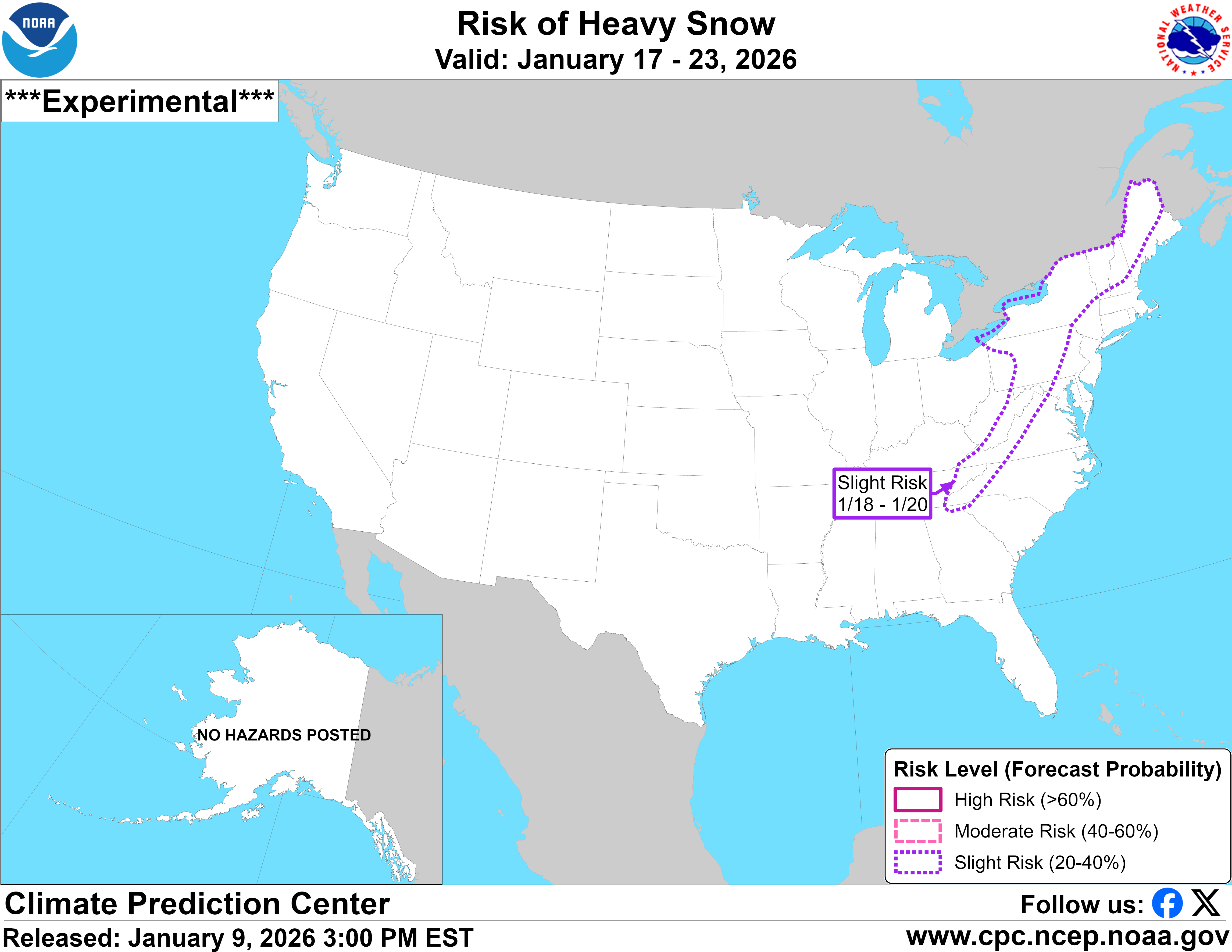
2025-2026 Fall/Winter Mountain Thread
Maggie Valley Steve replied to Buckethead's topic in Southeastern States
Afternoon update from the Climate Prediction Center regarding snow potential in the 7 to 14 day time frame.
-
2025-2026 Fall/Winter Mountain Thread
Maggie Valley Steve replied to Buckethead's topic in Southeastern States
It probably about that time when we start seeing some crazy computer runs for next week and just beyond. We're getting some very beneficial rain today. Possibly some thunder tonight and tomorrow as well. Perhaps that old rule plays out this time! -
2025-2026 Fall/Winter Mountain Thread
Maggie Valley Steve replied to Buckethead's topic in Southeastern States
Looking like we're going to get some beneficial rain tomorrow and especially Saturday ahead of the cold front. The Northern Mountains could see some flow snow late Saturday night into Sunday. Next week looks real interesting regarding any possibility of wintry weather particularly from the 15th going forward!
.png.1ff2255c6612bce10672ab6983d99241.png)


.png.de4fd237303b1e51029d35a335749968.png)