

Maggie Valley Steve
-
Posts
967 -
Joined
-
Last visited
Content Type
Profiles
Blogs
Forums
American Weather
Media Demo
Store
Gallery
Everything posted by Maggie Valley Steve
-

January 25/26 Jimbo Back Surgery Storm
Maggie Valley Steve replied to Jimbo!'s topic in Southeastern States
Not even worth posting. -
2025-2026 Fall/Winter Mountain Thread
Maggie Valley Steve replied to Buckethead's topic in Southeastern States
I had a low of 16 this morning. So I guess we'll be watching things unfold this week. -
2025-2026 Fall/Winter Mountain Thread
Maggie Valley Steve replied to Buckethead's topic in Southeastern States
Speaking of Carvers Gap in the Tennessee Valley forum. I'm borrowing this shot of the 12Z Euro ensemble for 150 hours. That's about as good as it can get 6 days out. Remember our next event will begin unfolding around Wednesday night/Thursday for N TX and Arkansas. The short term Mesoscale Guidance will be in range Tuesday for those areas. Also, that is brutally cold air dropping down from the Dekotas and Minnesota into the mid Mississippi/Ohio Valley!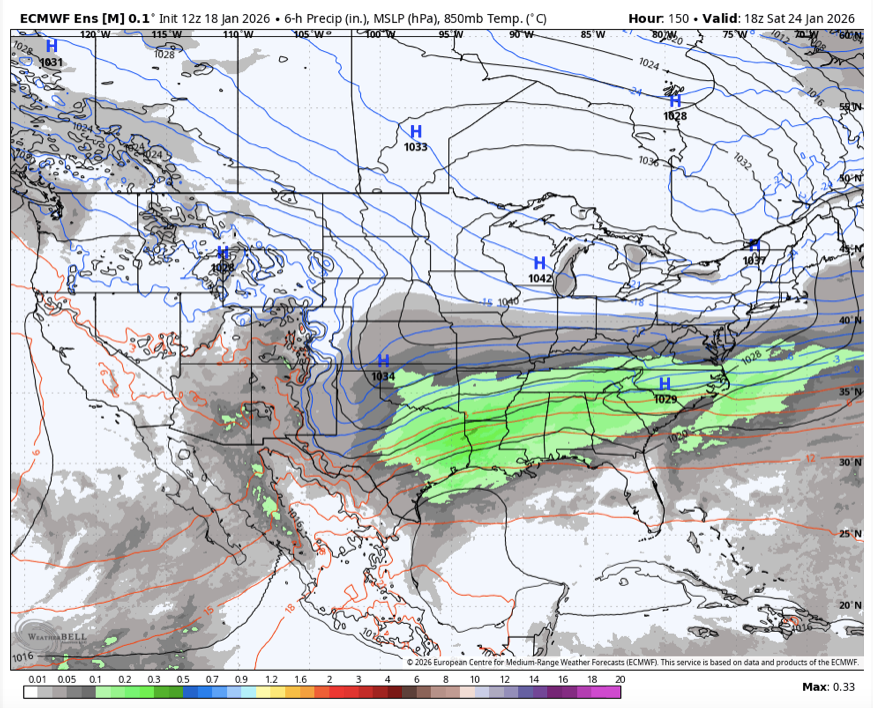
-
2025-2026 Fall/Winter Mountain Thread
Maggie Valley Steve replied to Buckethead's topic in Southeastern States
So the American/Canadian/European models all have the potential event next weekend. The Euro drops 19 inches of digital snow in the Valley..thumb.png.d743f775a7257a867a9e9031d8005605.png)
-
2025-2026 Fall/Winter Mountain Thread
Maggie Valley Steve replied to Buckethead's topic in Southeastern States
Hunter brings great insights with awesome knowledge of our "local" climates! Our group is truly amazing that brings a wealth of knowledge. When I moved here permanently in 2019 (I lived here during my last two years of college at Mars Hill back in the day late 70's), the Mountain group welcomed me and I found my fix for this disease we call weather! I certainly like our chances particularly next weekend and beyond! I suspect we'll have plenty of opportunities well into mid/late February. -
2025-2026 Fall/Winter Mountain Thread
Maggie Valley Steve replied to Buckethead's topic in Southeastern States
Temperature is starting to fall fairly quickly now. Currently 37 which was my morning low this morning after a high of 45. Now if we can just get some moisture. -
2025-2026 Fall/Winter Mountain Thread
Maggie Valley Steve replied to Buckethead's topic in Southeastern States
No accumulation at the house, but it looks like 2 to 3 inches above 3700 ft and Cataloochee reported 3 inches of fresh snow overnight. The mountains around the house look beautiful this morning! -
Jan 17-18 Sunday Funday Storm
Maggie Valley Steve replied to NorthHillsWx's topic in Southeastern States
It's been going on for decades! -
2025-2026 Fall/Winter Mountain Thread
Maggie Valley Steve replied to Buckethead's topic in Southeastern States
The Guest Suite just booked for the weekend so all is good! -
2025-2026 Fall/Winter Mountain Thread
Maggie Valley Steve replied to Buckethead's topic in Southeastern States
I don't know folks. The 12Z 3km NAM sure is keying in on the Balsams and Cataloochee Mountains overnight. That model suggests 6 to 8 inches around here. Cut the totals in half and it's still 3 to 4 inches..thumb.png.105ebbd56b076f6d98b7aecec5648858.png)
-
2025-2026 Fall/Winter Mountain Thread
Maggie Valley Steve replied to Buckethead's topic in Southeastern States
My low was 12 this morning. My high yesterday was 23. Cataloochee has been making snow non stop since 10 PM Wednesday night. The mountain looks awesome and ready for the busy Holiday Weekend! -
Jan 17-18 Sunday Funday Storm
Maggie Valley Steve replied to NorthHillsWx's topic in Southeastern States
GSP does the same along with most WFO's since about 2017 I believe. -
2025-2026 Fall/Winter Mountain Thread
Maggie Valley Steve replied to Buckethead's topic in Southeastern States
18Z 3km NAM has 5 inches for the Valley through Saturday morning..thumb.png.a707932d83d84d419376965f2af61dbc.png)
-
2025-2026 Fall/Winter Mountain Thread
Maggie Valley Steve replied to Buckethead's topic in Southeastern States
Light snow at the house currently. -
2025-2026 Fall/Winter Mountain Thread
Maggie Valley Steve replied to Buckethead's topic in Southeastern States
So GSP stated in their afternoon disco that snow totals have increased today for NE Georgia and the SW Mountains for tomorrow night into Saturday. That headline sounds familiar from the past couple days before last night. We'll see how it plays out. Currently light snow on Hemphill Bald and Cataloochee. -
2025-2026 Fall/Winter Mountain Thread
Maggie Valley Steve replied to Buckethead's topic in Southeastern States
The NAM gave me 4 inches and the Euro gives me 2 for Friday night/Saturday morning..thumb.png.6774d6c2a6b1138df416d003380bcda3.png)
-
2025-2026 Fall/Winter Mountain Thread
Maggie Valley Steve replied to Buckethead's topic in Southeastern States
I got Nam'ed Friday night to Saturday morning with 4 inches...lol -
2025-2026 Fall/Winter Mountain Thread
Maggie Valley Steve replied to Buckethead's topic in Southeastern States
19 this morning and a trace of snow. -
2025-2026 Fall/Winter Mountain Thread
Maggie Valley Steve replied to Buckethead's topic in Southeastern States
All snow now but very light. We'll see what the flow snow can deliver now. -
2025-2026 Fall/Winter Mountain Thread
Maggie Valley Steve replied to Buckethead's topic in Southeastern States
Same! Finally getting more snow than rain and it's definitely getting colder now. 35 currently with light snow mixed with some rain. Higher elevations definitely started earlier with the snow. -
2025-2026 Fall/Winter Mountain Thread
Maggie Valley Steve replied to Buckethead's topic in Southeastern States
It's currently pouring snow at Cataloochee with very gusty winds. It's coming. -
2025-2026 Fall/Winter Mountain Thread
Maggie Valley Steve replied to Buckethead's topic in Southeastern States
Same! Temperature has finally fallen to 37. -
2025-2026 Fall/Winter Mountain Thread
Maggie Valley Steve replied to Buckethead's topic in Southeastern States
Getting a few flakes mixing in with rain. I can't see the top of Buck Mountain (5K) right across Soco Rd from me. Big Bald just above Cataloochee is covered now with Moderate snow. 39 now at the house. -
2025-2026 Fall/Winter Mountain Thread
Maggie Valley Steve replied to Buckethead's topic in Southeastern States
Down to 40 here at the house with light rain, but the temperature is down 5 degrees the past hour. It won't be long here as well. -
2025-2026 Fall/Winter Mountain Thread
Maggie Valley Steve replied to Buckethead's topic in Southeastern States
Snowing at Cataloochee now.

.png.a31b96299476127b6885c07b8e081ab4.png)

.png.b928356fbb7e6e11e7d4fd96f5929150.png)
.png.a864d4fbd1bfde9f8a72815ccad1140b.png)
.png.afd14bc1b21cac7881bd4e87788e9764.png)