Maggie Valley Steve
-
Posts
979 -
Joined
-
Last visited
Content Type
Profiles
Blogs
Forums
American Weather
Media Demo
Store
Gallery
Everything posted by Maggie Valley Steve
-

2025-2026 Fall/Winter Mountain Thread
Maggie Valley Steve replied to Buckethead's topic in Southeastern States
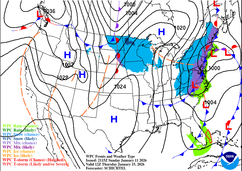
The WPC Updated afternoon surface charts for 12Z Wednesday and 12Z Thursday.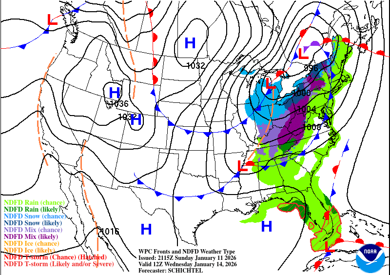
-
2025-2026 Fall/Winter Mountain Thread
Maggie Valley Steve replied to Buckethead's topic in Southeastern States
GSP in their afternoon disco suggest that we'll have a WWA event Wednesday night into Thursday for the Mountains. -
2025-2026 Fall/Winter Mountain Thread
Maggie Valley Steve replied to Buckethead's topic in Southeastern States
I am seeing a lot of positive trends in regards of the various computer schemes for the week ahead and even in the day 10 range. I'm seeing some potential for the Gulf upcoming as it is still very warm and capable of spinning up low pressure particularly along the NW and Central Gulf Coast. There is a decent stream of moisture from the Pacific heading our way along the Sub Tropical Jet. I'll be watching the Gulf carefully the next several days carefully. -
2025-2026 Fall/Winter Mountain Thread
Maggie Valley Steve replied to Buckethead's topic in Southeastern States
We are getting another snow shower in between breaks in the clouds. No accumulations and frankly I was a bit surprised that we would see snow today down to the Valley floor. Cataloochee is snowing and the snow guns are blowing! It should be a great week ahead for the ski areas with lots of opportunities to build back the snow pack! -
2025-2026 Fall/Winter Mountain Thread
Maggie Valley Steve replied to Buckethead's topic in Southeastern States
Actually, the Cabin got a 2 night booking Friday afternoon and added an additional night yesterday morning for MLK weekend! Fingers crossed the Guest Suite will book this week! -
2025-2026 Fall/Winter Mountain Thread
Maggie Valley Steve replied to Buckethead's topic in Southeastern States
Light snow in the Valley and roaring wind at times. -
2025-2026 Fall/Winter Mountain Thread
Maggie Valley Steve replied to Buckethead's topic in Southeastern States
Just emptied a bit over 2 inches from the gage. Looks like the heavier rain has shifted SE. -
2025-2026 Fall/Winter Mountain Thread
Maggie Valley Steve replied to Buckethead's topic in Southeastern States
Not too shabby of a trend through Thursday!.thumb.png.2e3c260503205a32c60559705ea29bf7.png)
-
2025-2026 Fall/Winter Mountain Thread
Maggie Valley Steve replied to Buckethead's topic in Southeastern States
I just had a clap of thunder! -
January 2026 Short/Medium Range Thread
Maggie Valley Steve replied to John1122's topic in Tennessee Valley
I'm praying for your Mom Powell. It's always tough when our parents are suffering. -
2025-2026 Fall/Winter Mountain Thread
Maggie Valley Steve replied to Buckethead's topic in Southeastern States
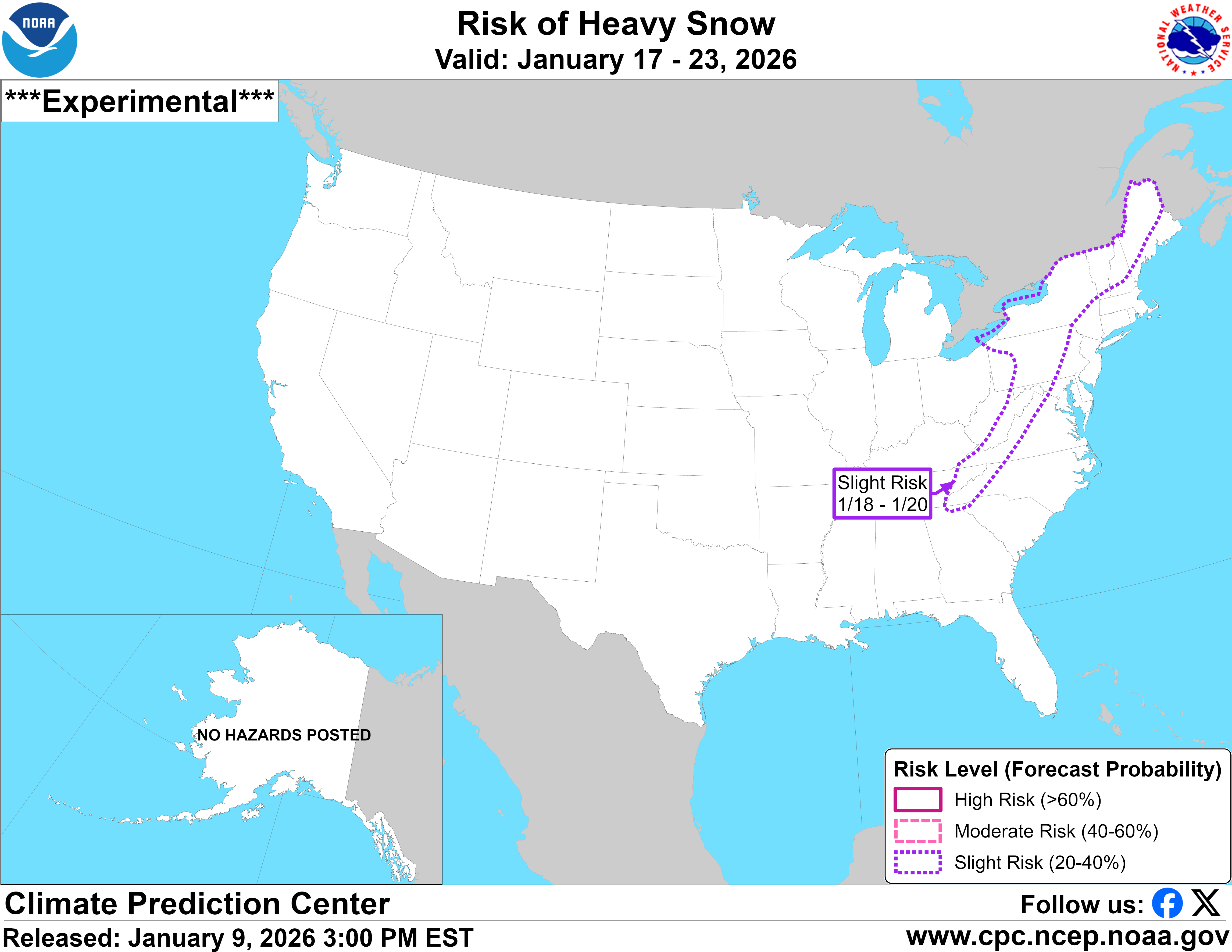
Afternoon update from the Climate Prediction Center regarding snow potential in the 7 to 14 day time frame.
-
2025-2026 Fall/Winter Mountain Thread
Maggie Valley Steve replied to Buckethead's topic in Southeastern States
It probably about that time when we start seeing some crazy computer runs for next week and just beyond. We're getting some very beneficial rain today. Possibly some thunder tonight and tomorrow as well. Perhaps that old rule plays out this time! -
2025-2026 Fall/Winter Mountain Thread
Maggie Valley Steve replied to Buckethead's topic in Southeastern States
Looking like we're going to get some beneficial rain tomorrow and especially Saturday ahead of the cold front. The Northern Mountains could see some flow snow late Saturday night into Sunday. Next week looks real interesting regarding any possibility of wintry weather particularly from the 15th going forward! -
2025-2026 Fall/Winter Mountain Thread
Maggie Valley Steve replied to Buckethead's topic in Southeastern States
It certainly is! I do wonder what social media these folks could have seen that prompted them to cancel more than 2 weeks away. Cataloochee has been blowing snow since last Sunday night every night including Tube World. -
2025-2026 Fall/Winter Mountain Thread
Maggie Valley Steve replied to Buckethead's topic in Southeastern States
We got 2 cancelations for the short term rentals for MLK Holiday Weekend because of no snow. We could use a big storm about now. -
2025-2026 Fall/Winter Mountain Thread
Maggie Valley Steve replied to Buckethead's topic in Southeastern States
It never got above freezing today at the house. Currently 21 and calm. -
2025-2026 Fall/Winter Mountain Thread
Maggie Valley Steve replied to Buckethead's topic in Southeastern States
17 for my low and nothing at the house. Lots of rime ice above 4000 ft though. I did see a report of flurries in Waynesville. -
2025-2026 Fall/Winter Mountain Thread
Maggie Valley Steve replied to Buckethead's topic in Southeastern States
I've enjoyed our "thaw" this week knowing it's about to come to an end Monday. Currently it's 65 at the house after yesterday's high of 67. Tomorrow looks warm as well. Looks like a good day to get a motorcycle ride in! Monday could be tricky with just enough moisture post Arctic front to wring out NWFS in those favored areas along the border. Windchill is going to bring winter reality for sure! -
2025-2026 Fall/Winter Mountain Thread
Maggie Valley Steve replied to Buckethead's topic in Southeastern States
Merry Christmas folks! Dr. Neil Frank passed away this morning surrounded by his loving family praying and singing hymns lying in bed with his loving wife Velma of 73 years. Neil was 94.
-
2025-2026 Fall/Winter Mountain Thread
Maggie Valley Steve replied to Buckethead's topic in Southeastern States
26 here this morning. On a personal note, my longtime mentor and friend Dr. Neil Frank is nearing the end of an extremely impactfull life particularly in the Weather World. His lovely wife Velma is in hospice care and Neil has joined her in hospice care. Neil and Velma have openly shared their faith in Christ and Neil still holds as the longest serving Director of the National Hurricane Center. I'm praying for a peaceful and painless passing for these two Saints! -
2025-2026 Fall/Winter Mountain Thread
Maggie Valley Steve replied to Buckethead's topic in Southeastern States
I just hit 60 for the first time in a month! It feels great too! -
2025-2026 Fall/Winter Mountain Thread
Maggie Valley Steve replied to Buckethead's topic in Southeastern States
I had a low of 26 this morning and a high of 54 this afternoon. It looks like wet weather arrives Thursday afternoon into the evening hours with a cold front. The models indicate we will have highs in the mid 50's and lows in the 30's this weekend heading into Christmas Eve. I'm enjoying a break from the cold temperatures frankly. It's certainly not a so called torch that the drama queens have been wringing their hands over! -
2025-2026 Fall/Winter Mountain Thread
Maggie Valley Steve replied to Buckethead's topic in Southeastern States
I had a low of 12 this morning. -
2025-2026 Fall/Winter Mountain Thread
Maggie Valley Steve replied to Buckethead's topic in Southeastern States
My temperature is down to 19 and the winds are gusty. Point and click say 12 for my low in the morning which is up from 8 early this morning. Cataloochee is reporting 11 currently. -
2025-2026 Fall/Winter Mountain Thread
Maggie Valley Steve replied to Buckethead's topic in Southeastern States
I'm surprised that we don't have much of any wind currently in the Valley. Under a bright cloudless sky and a temperature of 29, it doesn't feel bad at all out there right now.

.png.de4fd237303b1e51029d35a335749968.png)