Maggie Valley Steve
-
Posts
979 -
Joined
-
Last visited
Content Type
Profiles
Blogs
Forums
American Weather
Media Demo
Store
Gallery
Everything posted by Maggie Valley Steve
-

2025-2026 Fall/Winter Mountain Thread
Maggie Valley Steve replied to Buckethead's topic in Southeastern States
34 currently at the house and the first light frost of the Fall Season. -
2025-2026 Fall/Winter Mountain Thread
Maggie Valley Steve replied to Buckethead's topic in Southeastern States
My afternoon point and click forecast is showing 34 for the low Monday morning and again on Tuesday morning. Wednesday morning is showing 32. Next week is looking chilly. -
2025-2026 Fall/Winter Mountain Thread
Maggie Valley Steve replied to Buckethead's topic in Southeastern States
Always climo. That keeps them 'safe'...wink... -
2025-2026 Fall/Winter Mountain Thread
Maggie Valley Steve replied to Buckethead's topic in Southeastern States
We had a chilly low this morning of 40. A backdoor front arrives overnight will reinforce cooler temperatures and a chance of some showers Sunday with the arrival of a stronger front. The leaves in the Valley should be near peak this weekend. I'm seeing a trend in the longer range guidance suggesting stronger cold fronts pushing through until the end of October. Even some hints a snow showers in the longer range! -
2025-2026 Fall/Winter Mountain Thread
Maggie Valley Steve replied to Buckethead's topic in Southeastern States
We've had a nice stretch of amazing weather the last several days. Another cool front arrives Wednesday providing additional pleasant cool temperatures with a stronger shot of cool air and perhaps a shower or two this weekend. The fronts are becoming more frequent and progressive. The days are getting shorter and winter will be here before we know it! -
2025-2026 Fall/Winter Mountain Thread
Maggie Valley Steve replied to Buckethead's topic in Southeastern States
My low was 40 even with a low stratus deck. -
2025-2026 Fall/Winter Mountain Thread
Maggie Valley Steve replied to Buckethead's topic in Southeastern States
No chance of frost in the morning. We've been socked in with clouds since overnight last night. Even with the clouds this morning I managed a low of 49. -
2025-2026 Fall/Winter Mountain Thread
Maggie Valley Steve replied to Buckethead's topic in Southeastern States
Looking more likely we could our first frost Friday morning. Leaves around the house are almost done falling and we did a major leaf blowing today. The worst is almost over for me except for my allergies! -
2025-2026 Fall/Winter Mountain Thread
Maggie Valley Steve replied to Buckethead's topic in Southeastern States
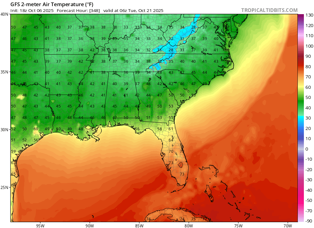
Take with a grain of salt, but the GFS has been rather insistent on a strong front arriving around the 20th to 21st. Our first freezing temperatures are near those dates climo wise.
-
2025-2026 Fall/Winter Mountain Thread
Maggie Valley Steve replied to Buckethead's topic in Southeastern States
Temperatures warmed overnight as the wind turn to the SE. Mugginess also returns with chances of rain until the next stout cold front arrives Wednesday. I'm seeing the cold fronts progressing fairly quickly in the medium range into long range. -
2025-2026 Fall/Winter Mountain Thread
Maggie Valley Steve replied to Buckethead's topic in Southeastern States
-
2025-2026 Fall/Winter Mountain Thread
Maggie Valley Steve replied to Buckethead's topic in Southeastern States
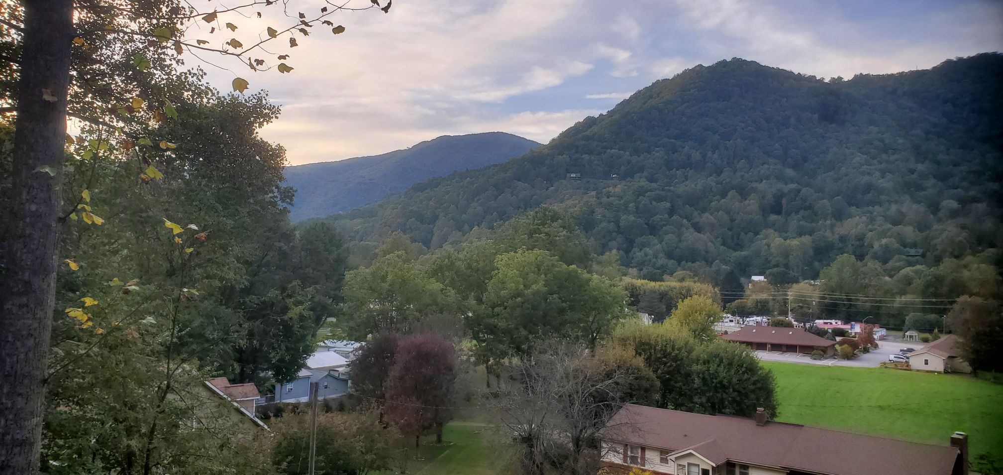
What a glorious day in the Valley today. Beautiful Carolina Blue skies and temperature briefly touched 70. The leaves are quickly beginning to drop across portions of the Parkway. My Poplar trees should be done next week which is the earliest I've seen in the past 5 years. This weekend should be peak for elevations above 5K. Temperatures in the upper 30’s tomorrow night and again on Saturday morning should escalate the leaf change down into the higher Valley location in the week ahead. -
2025-2026 Fall/Winter Mountain Thread
Maggie Valley Steve replied to Buckethead's topic in Southeastern States
We've been in the clouds all day with the Wedge firmly established. Drizzle has returned in earnest this evening in the Valley. I had a high of 69 today and a low this morning of 58. Thanks for sharing your amazing pictures Timm! I always look forward to you sharing! -
2025-2026 Fall/Winter Mountain Thread
Maggie Valley Steve replied to Buckethead's topic in Southeastern States
Breathe easy neighbors. I like our chance tonight. Cold air is coming!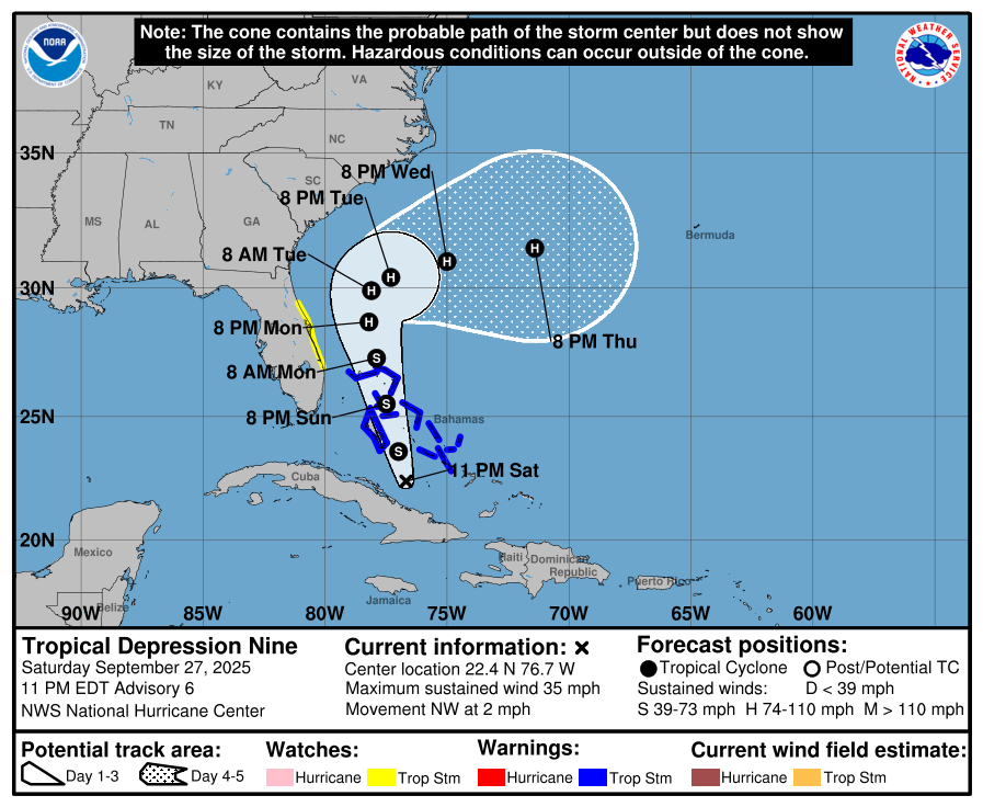
-
2025-2026 Fall/Winter Mountain Thread
Maggie Valley Steve replied to Buckethead's topic in Southeastern States
We're getting showers in the Valley now. Heavier rain looks likely for some.
-
TD 9 has formed via the 11AM NHC Update.
-
2025-2026 Fall/Winter Mountain Thread
Maggie Valley Steve replied to Buckethead's topic in Southeastern States
12Z Track guidance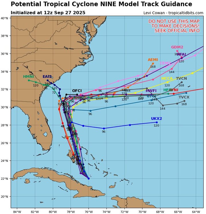
-
2025-2026 Fall/Winter Mountain Thread
Maggie Valley Steve replied to Buckethead's topic in Southeastern States
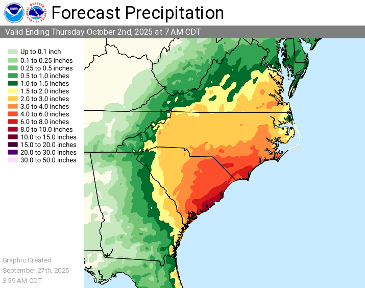
Morning Update from the WPC regarding excessive rainfall and amounts.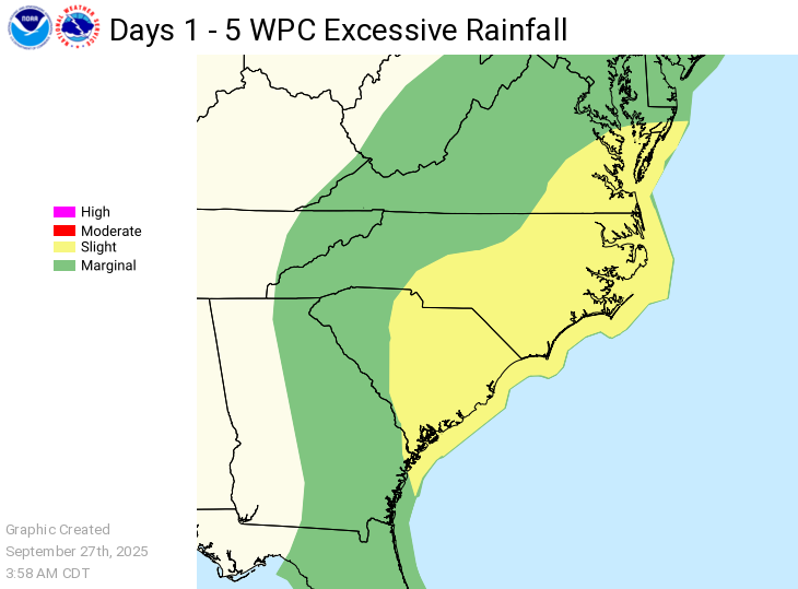
-
2025-2026 Fall/Winter Mountain Thread
Maggie Valley Steve replied to Buckethead's topic in Southeastern States
I just emptied 1.65 out of the rain gage for the last 72 hour. Most of that fell late Wednesday night into yesterday morning. -
2025-2026 Fall/Winter Mountain Thread
Maggie Valley Steve replied to Buckethead's topic in Southeastern States
The 12Z GFS solution suggests our Region could receive 3 to 5 inches of rain the next 6 days. There does not appear to be much of a wind threat via the GFS. We could manage that. -
2025-2026 Fall/Winter Mountain Thread
Maggie Valley Steve replied to Buckethead's topic in Southeastern States
The first low level recon is underway. So far there is no indication of surface circulation.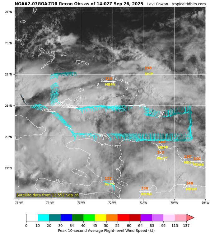
-
2025-2026 Fall/Winter Mountain Thread
Maggie Valley Steve replied to Buckethead's topic in Southeastern States
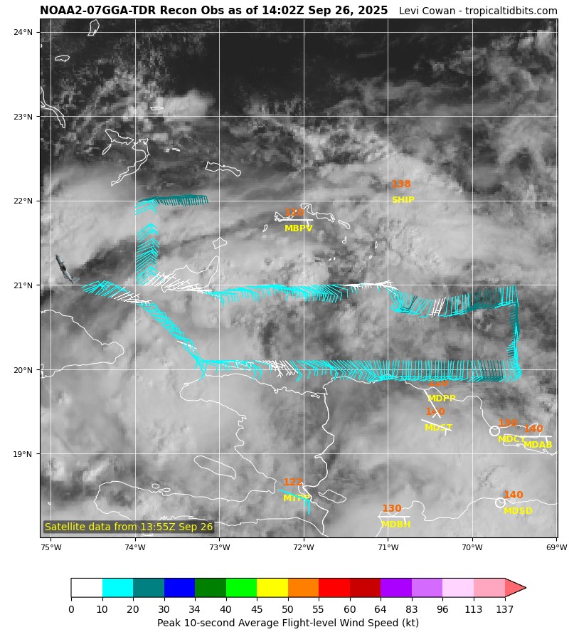
I'm not sold yet on the various model solutions for 94L. I'd feel more confident if we had days of agreement as we did last year with Helene. Once recon gets in for their standard cyclone sampling I believe we will get better agreement in the Hurricane and operational guidance. As you can see below, a lot of aircraft assets are being ramped up and the G-IV high altitude surveillance flights will be valuable for the upper air pattern conditions. 000 NOUS42 KNHC 251715 REPRPD WEATHER RECONNAISSANCE FLIGHTS CARCAH, NATIONAL HURRICANE CENTER, MIAMI, FL. 115 PM EDT THU 25 SEPTEMBER 2025 SUBJECT: TROPICAL CYCLONE PLAN OF THE DAY (TCPOD) VALID 26/1100Z TO 27/1100Z SEPTEMBER 2025 TCPOD NUMBER.....25-116 I. ATLANTIC REQUIREMENTS 1. SUSPECT AREA (NEAR HISPANIOLA - AL94) FLIGHT ONE - NOAA 49 FLIGHT TWO - NOAA 42 A. 27/0000Z A. 27/0000Z B. NOAA9 09GGA SURV B. NOAA2 10GGA TDR C. 26/1730Z C. 26/2000Z D. NA D. 22.3N 74.8W E. NA E. 26/2100Z TO 27/0300Z F. 41,000 TO 45,000 FT F. SFC TO 15,000 FT G. SYNOPTIC SURVEILLANCE G. TAIL DOPPLER RADAR H. NO WRA ACTIVATION H. WRA ACTIVATION FLIGHT THREE - TEAL 75 FLIGHT FOUR - NOAA 49 A. 27/0600Z A. 27/1200Z B. AFXXX 11GGA SURVEY B. NOAA9 12GGA SURV C. 27/0445Z C. 27/0530Z D. 22.8N 75.3W D. NA E. 27/0530Z TO 27/0900Z E. NA F. SFC TO 15,000 FT F. 41,000 TO 45,000 FT G. SYSTEM SURVEY G. SYNOPTIC SURVEILLANCE H. WRA ACTIVATION H. NO WRA ACTIVATION FLIGHT FIVE - NOAA 42 FLIGHT SIX - TEAL 76 A. 27/1200Z A. 27/1130,1730Z B. NOAA2 1309A CYCLONE B. AFXXX 1409A CYCLONE C. 27/0800Z C. 27/1015Z D. 23.2N 75.7W D. 23.2N 75.7W E. 27/0900Z TO 27/1600Z E. 27/1100Z TO 27/1730Z F. SFC TO 15,000 FT F. SFC TO 15,000 FT G. TAIL DOPPLER RADAR G. FIX H. WRA ACTIVATION H. WRA ACTIVATION 2. OUTLOOK FOR SUCCEEDING DAY: A. CONTINUE 6-HOURLY FIXES IF SYSTEM DEVELOPS AND IS A THREAT. B. TWO MORE NOAA P-3 TAIL DOPPLER RADAR MISSIONS INTO AL94 FOR 28/0000Z AND 28/1200Z, DEPARTING KLAL AT 27/2000Z AND 28/0800Z RESPECTIVELY. C. TWO MORE NOAA 49 G-IV SYNOPTIC SURVEILLANCE MISSIONS AROUND AL94 FOR THE 28/0000Z AND 28/1200Z SYNOPTIC TIMES, DEPARTING KLAL AT 27/1730Z AND 28/0530Z RESPECTIVELY. 3. REMARKS: A. THE TEAL 75 AND TEAL 76 MISSIONS INTO AL94 TASKED IN TCPOD 25-116 WERE CANCELED BY NHC AT 25/1200Z. B. THE TEAL 74 MISSION INTO AL94 HAS BEEN CHANGED TO A LOW-LEVEL INVEST NEAR 21.9N 74.2W FOR 26/1730Z, WITH THE TAKEOFF TIME CHANGED 6 HOURS TO 26/1545Z. II. PACIFIC REQUIREMENTS 1. NEGATIVE RECONNAISSANCE REQUIREMENTS. 2. OUTLOOK FOR SUCCEEDING DAY.....NEGATIVE. $$ KAL -
2025-2026 Fall/Winter Mountain Thread
Maggie Valley Steve replied to Buckethead's topic in Southeastern States
And there's the first statement from GSP this evening.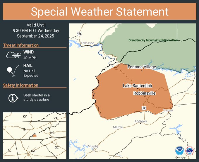
-
2025-2026 Fall/Winter Mountain Thread
Maggie Valley Steve replied to Buckethead's topic in Southeastern States
Big slow moving storms moving into the far SW Mountain Counties. GSP stated in their afternoon disco that rain chance increase over the Mountains overnight into tomorrow morning. Nothing looks severe, but there is so very rich tropical moisture out there and heavy rainfall is a possibility. -
Category Five Hurricane Humberto
Maggie Valley Steve replied to WxWatcher007's topic in Tropical Headquarters
NHC will initiate Advisories for TS Humberto at 5 PM.