Maggie Valley Steve
-
Posts
979 -
Joined
-
Last visited
Content Type
Profiles
Blogs
Forums
American Weather
Media Demo
Store
Gallery
Everything posted by Maggie Valley Steve
-

2025-2026 Fall/Winter Mountain Thread
Maggie Valley Steve replied to Buckethead's topic in Southeastern States
It's pour snow at 21 degrees. I've picked up an inch in the last 20 minutes. -
2025-2026 Fall/Winter Mountain Thread
Maggie Valley Steve replied to Buckethead's topic in Southeastern States
Cataloochee Ski Area will officially open for the season this Wednesday! Tube World has the snow guns blowing and the hill is covered now! -
2025-2026 Fall/Winter Mountain Thread
Maggie Valley Steve replied to Buckethead's topic in Southeastern States
23 with light to moderate snow at times. It's starting to lay on the grass and roads now. -
2025-2026 Fall/Winter Mountain Thread
Maggie Valley Steve replied to Buckethead's topic in Southeastern States
Visible imagery suggests gravity waves are developing just ahead of the potent vort max. I'm starting to see some rising cumulus suggesting the possibility of thundersnow just E of the Knoxville Region. -
2025-2026 Fall/Winter Mountain Thread
Maggie Valley Steve replied to Buckethead's topic in Southeastern States
Snow showers have spilled over mountains into the Valley now. -
2025-2026 Fall/Winter Mountain Thread
Maggie Valley Steve replied to Buckethead's topic in Southeastern States
Looking upstream there a bubbly cumulus building ahead of the potent vort max that is diving SSE. It appears to be digging enough to put the SW Mountains in play this afternoon and evening for moderate to heavy snow. Clouds are beginning to build back in around the Valley and snow flurries have increased a bit. In a couple of hours we should begin to see more widespread reports coming in. -
2025-2026 Fall/Winter Mountain Thread
Maggie Valley Steve replied to Buckethead's topic in Southeastern States
Just rode up to Cataloochee. 18 and light snow currently. The top of Fie Top Rd was icy, but the salt trucks were laying salt down. Looked like a couple of inches above 5K. Back down in the Valley it's 27 with occasional flurries. -
2025-2026 Fall/Winter Mountain Thread
Maggie Valley Steve replied to Buckethead's topic in Southeastern States
Light snow and a dusting with 27 at the house. GSP says the potent vort max will bring heavier snow this afternoon and evening than previously expected. -
2025-2026 Fall/Winter Mountain Thread
Maggie Valley Steve replied to Buckethead's topic in Southeastern States
Flurries are flying at Cataloochee now. 30F currently. -
2025-2026 Fall/Winter Mountain Thread
Maggie Valley Steve replied to Buckethead's topic in Southeastern States
32 at Cataloochee. Good to see reports coming in from our neighbors in Eastern Tennessee! It won't be long now. -
2025-2026 Fall/Winter Mountain Thread
Maggie Valley Steve replied to Buckethead's topic in Southeastern States
Same here as well. -
2025-2026 Fall/Winter Mountain Thread
Maggie Valley Steve replied to Buckethead's topic in Southeastern States
GSP mentioned 25:1 ratios tomorrow afternoon and night along with convective snow dropping an inch an hour rates! -
2025-2026 Fall/Winter Mountain Thread
Maggie Valley Steve replied to Buckethead's topic in Southeastern States
Cataloochee snow makers are busy placing portable snow guns around the base this morning. Looks like a good 36 to 48 hours of snow making on the mountain and also at Tube World in town! -
2025-2026 Fall/Winter Mountain Thread
Maggie Valley Steve replied to Buckethead's topic in Southeastern States
The GFS finally has shifted the secondary cold core upper low south into the Mountains. That secondary feature has the potential for a heavy burst of snow that could break containment and spill into the foothills. -
2025-2026 Fall/Winter Mountain Thread
Maggie Valley Steve replied to Buckethead's topic in Southeastern States
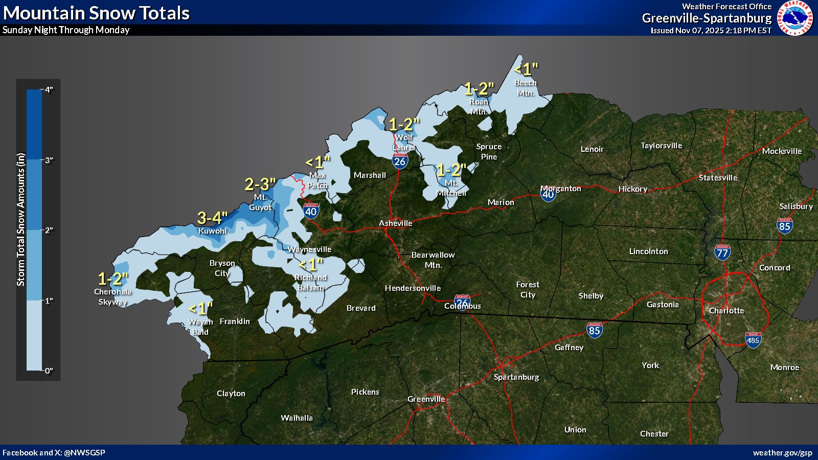
GSP first snowfall map.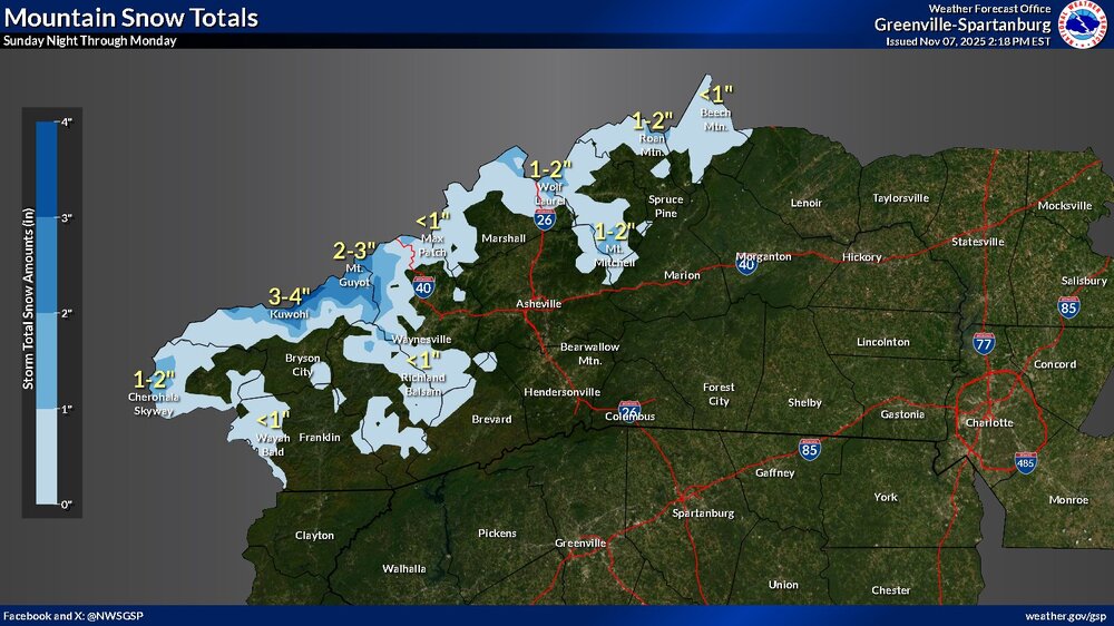
-
2025-2026 Fall/Winter Mountain Thread
Maggie Valley Steve replied to Buckethead's topic in Southeastern States
Looks like the 12Z Suite of guidance has come in a bit better agreement regarding the NWFS event Sunday night into Tuesday. Temperatures are really going to shock the system with windchill values in the single digits and highs on Monday not getting above freezing. -
2025-2026 Fall/Winter Mountain Thread
Maggie Valley Steve replied to Buckethead's topic in Southeastern States
30 with heavy frost this morning. -
2025-2026 Fall/Winter Mountain Thread
Maggie Valley Steve replied to Buckethead's topic in Southeastern States
Looks like we will have relatively quiet week ahead with daytime highs in the 60's and lows in the upper 30’s to 40’s. A mainly zonal flow should hold until next weekend, then changes are brewing. The various computer schemes suggest a strong Great Lakes gale developing and moderate to heavy snow across portions of the Region. There are hints of snow upslope snow showers along the border Counties late next weekend depending on timing. I continue to see signs that indicate the possibility of below normal temperatures and storm chances into the Thanksgiving Holiday period. -
2025-2026 Fall/Winter Mountain Thread
Maggie Valley Steve replied to Buckethead's topic in Southeastern States
29 this morning with heavy frost on the Valley floor. -
2025-2026 Fall/Winter Mountain Thread
Maggie Valley Steve replied to Buckethead's topic in Southeastern States
Woke up to 33 this morning with frost. I just emptied 3.24 inches out the gage for the week. Not too shabby at all! -
2025-2026 Fall/Winter Mountain Thread
Maggie Valley Steve replied to Buckethead's topic in Southeastern States
What a raw wet day in the Valley. Temperature started out in the upper 30’s and has managed to 'heat up' to the mid and upper 40’s this afternoon. GSP stated in their afternoon disco that the freezing levels are beginning to drop rather quickly and a good chance for snow showers from 3500 ft and the possibility of some light accumulations. -
2025-2026 Fall/Winter Mountain Thread
Maggie Valley Steve replied to Buckethead's topic in Southeastern States
We've been stuck in the soup for 3 days with temperatures stuck in the 40's. It looks like there may be a wintry mix Thursday night into Friday morning above 5K and freezing temperatures possible early Saturday morning. I'm keeping an eye on early next as yet another Gulf Coast low organizes with an digging upper trough and robust cold front headed our way. The models have flipped from a clipper to a wrapped meandering upper low. If this is the pattern ahead as we head into November, things could become interesting. -
2025-2026 Fall/Winter Mountain Thread
Maggie Valley Steve replied to Buckethead's topic in Southeastern States
42 and rain this morning. It's going to be an interesting week weather wise. Thursday night into Friday morning we should be under the influence of a potent cold core upper low. Temperatures look marginal at this range, but surprises often occur in a transitioning pattern. I continue to see additional changes towards a colder regime and periods of unsettled weather. Oh, and they have started making a snow mound at Tube World last week. Tis the season! -
2025-2026 Fall/Winter Mountain Thread
Maggie Valley Steve replied to Buckethead's topic in Southeastern States
Coldest air of the Fall Season so far ahead for early Friday morning. My 8 to 10 day long range forecast is depicting snow next Thursday and Halloween. If the model trends hold into early next week, we may have a legitimate chance of at least some up slope snow. We will see what if any influence Melissa and a potent upper low dropping out of Canada bring regarding our sensible weather..png.740949cc07c208c0c78d622fd9923711.png)
-
2025-2026 Fall/Winter Mountain Thread
Maggie Valley Steve replied to Buckethead's topic in Southeastern States
43 this morning in the Valley.