-
Posts
900 -
Joined
-
Last visited
Content Type
Profiles
Blogs
Forums
American Weather
Media Demo
Store
Gallery
Everything posted by Maggie Valley Steve
-
2025 Spring/Summer Mountain Thread
Maggie Valley Steve replied to Maggie Valley Steve's topic in Southeastern States
What beautiful glorious day across the Smokies! Perfect temperature to be out side and clear blue Carolina Skies. I always enjoy when almost an inch of rain brings so much Greenup. I'm going to begin tackling one of the decks in preparation for restraining tomorrow. Hopefully the rain will hold off until late Thursday! -

2025 Spring/Summer Mountain Thread
Maggie Valley Steve replied to Maggie Valley Steve's topic in Southeastern States
-

2025 Spring/Summer Mountain Thread
Maggie Valley Steve replied to Maggie Valley Steve's topic in Southeastern States
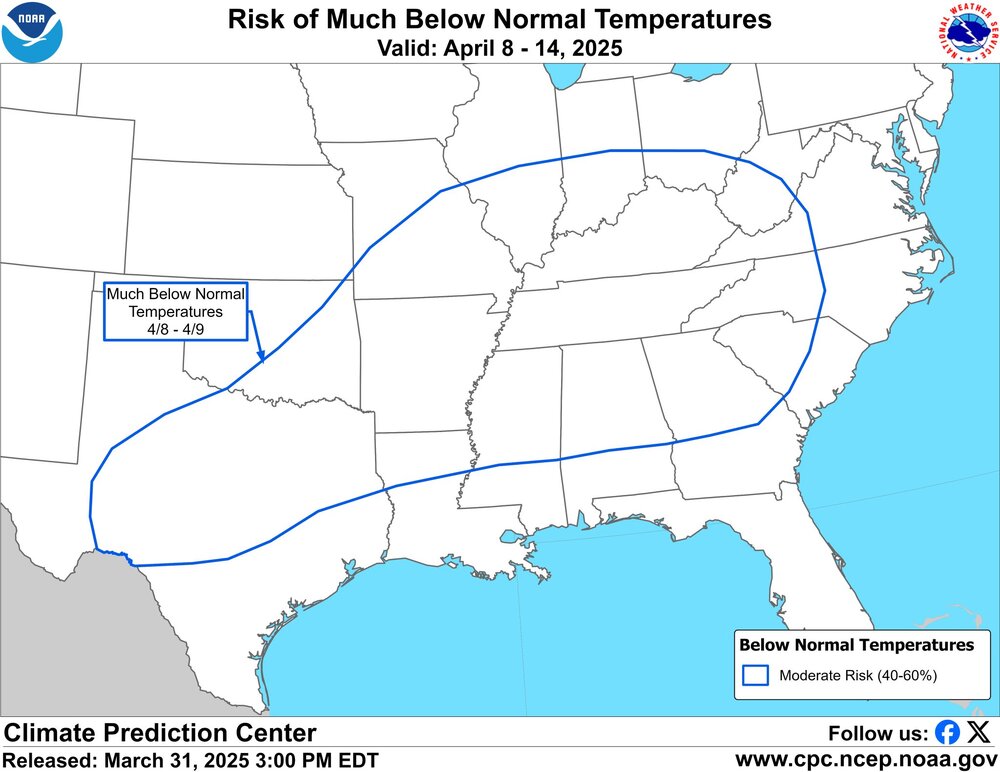
It was great hearing thunder rumbling and heavy showers this morning! We had off and on showers most of the day yesterday and more rain coming today ahead and along the cold front. Looks like additional rainfall Wednesday into Thursday too. I've been enjoying this transition to Spring, but it sure looks like another shot of winter is ahead for next week. -

2025 Spring/Summer Mountain Thread
Maggie Valley Steve replied to Maggie Valley Steve's topic in Southeastern States
6 months ago today our Region was experiencing what is likely the most widespread Major Weather Events in generations from Helene. Currently we continue to live with the aftermath of that Historic Event with wildfires burning across our Mountains. Hopefully our very dry and dangerous wildfire conditions will relax next week with a chance of some beneficial rainfall. I hope all of our neighbors are doing well! -

2025 Spring/Summer Mountain Thread
Maggie Valley Steve replied to Maggie Valley Steve's topic in Southeastern States
I ended up with a half inch of measurable snow, but it took about 4 hours to finally begin to stick. My low was 24 this morning. It's beginning to look like an active pattern with a rather vigorous Eastern Trough persisting into early April. The impact the the stratospheric Polar Vortex collapse in early March is being felt. -

2025 Spring/Summer Mountain Thread
Maggie Valley Steve replied to Maggie Valley Steve's topic in Southeastern States
Ground is covered to the Valley floor. I'll call it moderate snow with very little wind. -

2025 Spring/Summer Mountain Thread
Maggie Valley Steve replied to Maggie Valley Steve's topic in Southeastern States
It's starting to lay on the decks and vegetation. Temperature down to 34 now. -

2025 Spring/Summer Mountain Thread
Maggie Valley Steve replied to Maggie Valley Steve's topic in Southeastern States
Flurries at the house and 38. -

2025 Spring/Summer Mountain Thread
Maggie Valley Steve replied to Maggie Valley Steve's topic in Southeastern States
Flurries at Cataloochee now. -

2025 Spring/Summer Mountain Thread
Maggie Valley Steve replied to Maggie Valley Steve's topic in Southeastern States
I started out this morning at 57. Rain moved in around 8AM and the temperature slowly dropped to 48 and stayed there until an hour ago. Clouds have now moved in and the deck is lowering with temperature falling quickly to 40 currently. Radar returns are showing up along the border as well as E TN. Cataloochee should have flurries shortly. -

2025 Spring/Summer Mountain Thread
Maggie Valley Steve replied to Maggie Valley Steve's topic in Southeastern States
The short term Mesoscale Models are advertising we may see some minor accumulations of snow tomorrow night, particularly for the Smokies. GSP grids suggests the even here in the Valley an inch ou two is possible. -

2025 Spring/Summer Mountain Thread
Maggie Valley Steve replied to Maggie Valley Steve's topic in Southeastern States
No snow flurries in Maggie as far as I know. It's chilly though. The models indicate perhaps a better chance Thursday night for the Mountains and possibly the Valleys. The ensembles suggest we may return to a cold phase next week as well. -

2025 Spring/Summer Mountain Thread
Maggie Valley Steve replied to Maggie Valley Steve's topic in Southeastern States
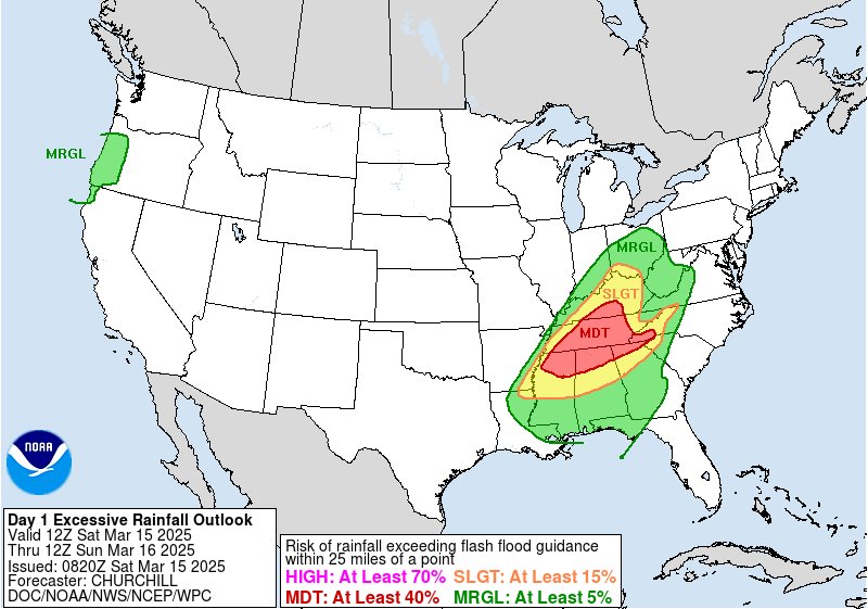
Looking like we're shifting to a heavy rainfall threat and some gusty winds in the heavier thunderstorms early in the morning. Temperature has dropped to 56 here at the house. -

2025 Spring/Summer Mountain Thread
Maggie Valley Steve replied to Maggie Valley Steve's topic in Southeastern States
The Heavy Rainfall threat has increased, particularly for the SW Mountains this afternoon into tomorrow morning. -

2025 Spring/Summer Mountain Thread
Maggie Valley Steve replied to Maggie Valley Steve's topic in Southeastern States
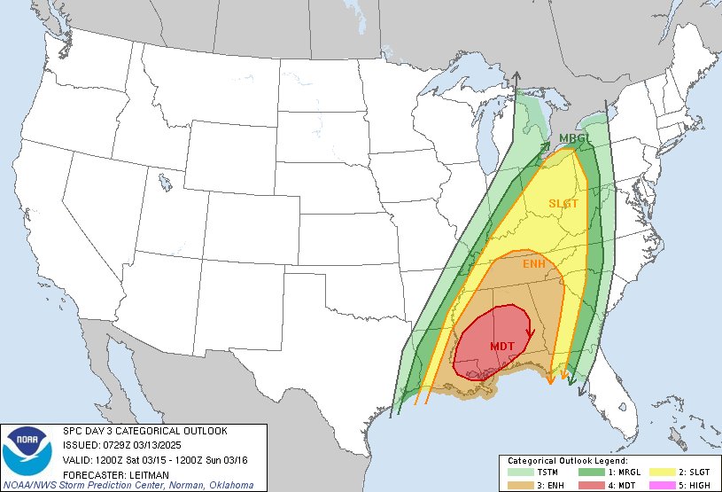
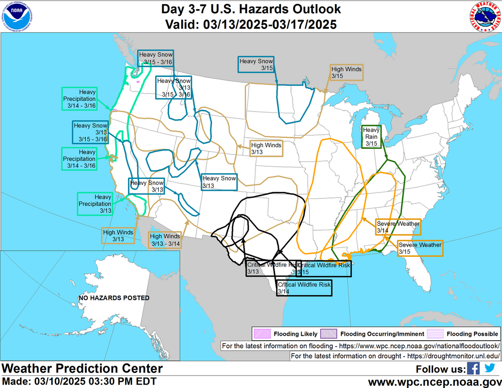
Time to watch carefully for a severe weather potential along with the possibility of heavy rainfall Saturday afternoon into early Sunday. -

2025 Spring/Summer Mountain Thread
Maggie Valley Steve replied to Maggie Valley Steve's topic in Southeastern States
First 70 of the year today! What an amazing beautiful day it has been! -

2025 Spring/Summer Mountain Thread
Maggie Valley Steve replied to Maggie Valley Steve's topic in Southeastern States
-

2024-2025 Fall/Winter Mountain Thread
Maggie Valley Steve replied to Buckethead's topic in Southeastern States
Really surprised to see a dusting down to the Valley floor this morning. There definitely has been a lot of wind blown snow. It's actually very powdery and blowing off the driveway. -

2024-2025 Fall/Winter Mountain Thread
Maggie Valley Steve replied to Buckethead's topic in Southeastern States
I've got a dusting here this morning and 28. -

2024-2025 Fall/Winter Mountain Thread
Maggie Valley Steve replied to Buckethead's topic in Southeastern States
Still raining at the house, definitely moderate snow at Cataloochee. -

2024-2025 Fall/Winter Mountain Thread
Maggie Valley Steve replied to Buckethead's topic in Southeastern States
Snow up on Hemphill Bald above Cataloochee. -

2024-2025 Fall/Winter Mountain Thread
Maggie Valley Steve replied to Buckethead's topic in Southeastern States
Special Weather Statement National Weather Service Greenville-Spartanburg SC 240 PM EST Wed Mar 5 2025 NCZ033-048>052-058-061200- Avery-Madison-Yancey-Mitchell-Swain-Haywood-Graham- Including the cities of Ingalls, Banner Elk, Newland, Faust, Mars Hill, Marshall, Walnut, Allenstand, Hot Springs, Luck, Swiss, Burnsville, Celo, Micaville, Ramseytown, Busick, Spruce Pine, Poplar, Alarka, Almond, Bryson City, Luada, Wesser, Waynesville, Waterville, Canton, Cruso, Cove Creek, Robbinsville, and Stecoah 240 PM EST Wed Mar 5 2025 ...LIGHT SNOW ACCUMMULATIONS ALONG TENNESSEE BORDER TONIGHT... NW flow snow is expected to begin later tonight for the higher elevations along the Tennessee/North Carolina border. Accumulations of 1-2 inches likely with locally higher amounts up to 3 inches possible. Snow should start to taper off by sunrise with a few lingering flurries possible through mid-morning Thursday. -

2024-2025 Fall/Winter Mountain Thread
Maggie Valley Steve replied to Buckethead's topic in Southeastern States
Looks like some of that W Texas dust has blown in as well. Perhaps a dusting to an inch of snow here with a W to WNW component of wind tonight. -

2024-2025 Fall/Winter Mountain Thread
Maggie Valley Steve replied to Buckethead's topic in Southeastern States
The wind is really picking up above the Valley floor this afternoon. Some of the prolonged gusts sound like very low flying jets . Stay safe out there! -

2024-2025 Fall/Winter Mountain Thread
Maggie Valley Steve replied to Buckethead's topic in Southeastern States
23 this morning.


