Maggie Valley Steve
-
Posts
979 -
Joined
-
Last visited
Content Type
Profiles
Blogs
Forums
American Weather
Media Demo
Store
Gallery
Everything posted by Maggie Valley Steve
-

2025-2026 Fall/Winter Mountain Thread
Maggie Valley Steve replied to Buckethead's topic in Southeastern States
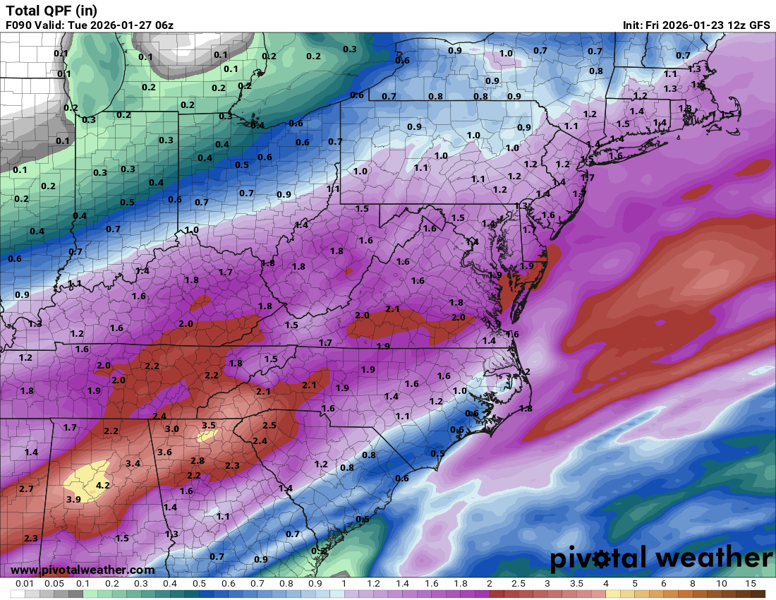
12Z GFS QPF totals thru 90 hours.
-
2025-2026 Fall/Winter Mountain Thread
Maggie Valley Steve replied to Buckethead's topic in Southeastern States
Yeah, I know. Duke came in before Helene and upgraded everything on the main line including new poles. Brand new wire and brand new transformers. They been working the right of ways the past Month cutting back tree growth near the lake and the high tension lines coming over the mountains as well as feeder lines. -
2025-2026 Fall/Winter Mountain Thread
Maggie Valley Steve replied to Buckethead's topic in Southeastern States
I'm wondering how long the electric grid will hold up in Maggie. We're on a buried electric cable from the main line running along Soco Rd. Fingers crossed the qpf is light and we rise above freezing early Sunday. Ugh... -
2025-2026 Fall/Winter Mountain Thread
Maggie Valley Steve replied to Buckethead's topic in Southeastern States
Ken Graham is doing a great job across social media and cable hitting hard the dangers from ice and what the NWS is doing from a public information and forecasting perspective. Ken is a great manager or 'cat herder' as it's affectionately referred to in the weather service circles. Ken was the Meteorologist in Charge for NWS Slidell, LA during Katrina. He later moved to the NHC as Director and now Director of the NWS. -
2025-2026 Fall/Winter Mountain Thread
Maggie Valley Steve replied to Buckethead's topic in Southeastern States
The G-IV flew its High Altitude mission this afternoon. I'm looking forward to see what results we see with the 00Z Guidance. -
2025-2026 Fall/Winter Mountain Thread
Maggie Valley Steve replied to Buckethead's topic in Southeastern States
Warnings will go up tomorrow morning per GSP. Ice Storm Warning or Winter Storm Warning remains to be seen. I've got to say the GFS has led the way with the Storm in various ways. -
2025-2026 Fall/Winter Mountain Thread
Maggie Valley Steve replied to Buckethead's topic in Southeastern States
I'm getting concerned that once the very cold air settles in, we aren't going really warm up at all next week and then we get another shot at wintry weather next Thursday night/Friday morning with a big time dump of Artic air where temperatures may approach-40 to -50 below normal. What happens this weekend if we can't get above freezing we may well be locked in to icebox for the next 10 to 15 days if not longer. We have a shot at wintry mischief tonight as well. -
2025-2026 Fall/Winter Mountain Thread
Maggie Valley Steve replied to Buckethead's topic in Southeastern States
For the record....png.8daf4859e91a9b15044edab18e221099.png)
-
2025-2026 Fall/Winter Mountain Thread
Maggie Valley Steve replied to Buckethead's topic in Southeastern States
This sure is looking like 48 to possibly a near 60 hour event for precipitation for the Mountains. Ugly ugly ugly. There is nothing good about this. Major Winter Storm approaching catastrophic if these trends continue. -
2025-2026 Fall/Winter Mountain Thread
Maggie Valley Steve replied to Buckethead's topic in Southeastern States
I had a sheet of ice on my asphalt driveway this morning and almost slipped on my backside. Not expected or forecasted. Hunter is right about the short-term guidance. We've been monitoring the Globals for a week now. Attention turns to the shorter range high resolution guidance for more nuanced possibilities. -
1/23/26-1/25/26 Winter Storm Thread
Maggie Valley Steve replied to AMZ8990's topic in Tennessee Valley
Glad you folks are monitoring my buddy Jeremy. He is a great Meteorologist and a great guy that updates Twitter regularly when the 53rd is active not only for Hurricanes! -
2025-2026 Fall/Winter Mountain Thread
Maggie Valley Steve replied to Buckethead's topic in Southeastern States
So my buddy Jeremy DeHart posted on Twitter that the sampling of the Baja low will be in the 00Z GFS and ECMWF tonight, but could take a couple of cycles to settle the guidance down. He also stated the the missions tomorrow in the Gulf will offer thermal profiles to better assist guidance going forward.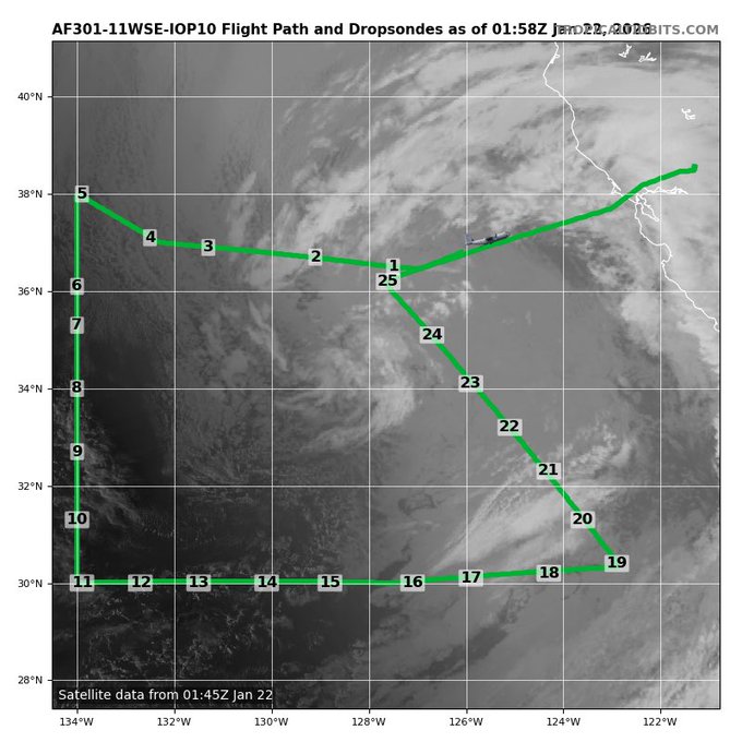
-
2025-2026 Fall/Winter Mountain Thread
Maggie Valley Steve replied to Buckethead's topic in Southeastern States
How about them appetizers! Not a cloud in the sky and 43. -
2025-2026 Fall/Winter Mountain Thread
Maggie Valley Steve replied to Buckethead's topic in Southeastern States
We're going to get a G-IV high altitude Recon mission tomorrow evening! -
2025-2026 Fall/Winter Mountain Thread
Maggie Valley Steve replied to Buckethead's topic in Southeastern States
Afternoon update Day 4 Outlook for snow..gif.12766f60d088b3c53d6bac4fbc0b65dd.gif)
-
2025-2026 Fall/Winter Mountain Thread
Maggie Valley Steve replied to Buckethead's topic in Southeastern States
No new data from RECON until tomorrow. -
2025-2026 Fall/Winter Mountain Thread
Maggie Valley Steve replied to Buckethead's topic in Southeastern States
It's an excuse to become emotionally unattached to the anything to do with a storm of this potential. I've seen it for years with Tropical Systems. Human nature is still what it is . -
2025-2026 Fall/Winter Mountain Thread
Maggie Valley Steve replied to Buckethead's topic in Southeastern States
My hunch is that the GFS is handling the very cold and dense Arctic front better this time. I'm also watching Texas carefully as well. It appears the freezing temperatures will make it to the Coast on Friday evening/early Saturday morning creating and icy mess across Metro Houston and possibly Galveston. So today into tomorrow should provide a bit more clarity and then we can start exploring p-types and amounts. -
2025-2026 Fall/Winter Mountain Thread
Maggie Valley Steve replied to Buckethead's topic in Southeastern States
So I got some clarity from Jeremy DeHart on Twitter. Jeremy is an AF Reserve Meteorologist for the Hurricane Hunter missions for many years now. He stated that last night mission was a reposition flight back to Keesler. The mission today will sample the Baja low with additional missions sampling the Gulf tomorrow. -
2025-2026 Fall/Winter Mountain Thread
Maggie Valley Steve replied to Buckethead's topic in Southeastern States
Currently 20 at the house and heavy frost. GSP stated in the morning AFD that Winter Storm Watch is coming later today. The WPC in their morning discussions suggested that there is still a great deal of uncertainty with too much run to run inconsistencies and and too much uncertainty in the Northern stream energy. They stated that the North trend is noted, but they're no buying yet. -
January 25/26 Jimbo Back Surgery Storm
Maggie Valley Steve replied to Jimbo!'s topic in Southeastern States
You folks are already under a Winter Storm Watch aren't you? -
2025-2026 Fall/Winter Mountain Thread
Maggie Valley Steve replied to Buckethead's topic in Southeastern States
Recon is already sampling the upper low. They flew out of Honolulu. Hopefully we will see that data ingest begin by 6Z and definitely by 12Z tomorrow. -
January 25/26 Jimbo Back Surgery Storm
Maggie Valley Steve replied to Jimbo!'s topic in Southeastern States
You live in Southern Virginia don't you? -
2025-2026 Fall/Winter Mountain Thread
Maggie Valley Steve replied to Buckethead's topic in Southeastern States
It's sort of gotten lost in the Big Dog, but my point and click has rain/snow chance developing tomorrow evening and continuing into Friday morning. It does look like the high for the week will be tomorrow here at the house in the low to mid 40’s. I've been at or near freezing since last Saturday morning. -
January 25/26 Jimbo Back Surgery Storm
Maggie Valley Steve replied to Jimbo!'s topic in Southeastern States
We're going to get Winter RECON sampling the upper low ENE of Hawaii tomorrow with additional Atmospheric River sampling over the Eastern Pacific for the moisture headed our way.