
Maggie Valley Steve
-
Posts
866 -
Joined
-
Last visited
Content Type
Profiles
Blogs
Forums
American Weather
Media Demo
Store
Gallery
Everything posted by Maggie Valley Steve
-

2025-2026 Fall/Winter Mountain Thread
Maggie Valley Steve replied to Buckethead's topic in Southeastern States
Like last evening, temperature is falling quickly but I do have a bit of breeze this evening. My high was 49 today and have dropped to 38 under clear skies. Hunter in his afternoon post on X stated that this is a two part system. The first coming early tomorrow morning and lasting to around 10 AM. The second part of this system should arrive after 3 PM and he believes this one will drop 2 to 3 inches across the Smokies and Balsams. He stated it should wrap up before daybreak Tuesday morning. -
2025-2026 Fall/Winter Mountain Thread
Maggie Valley Steve replied to Buckethead's topic in Southeastern States
The 12Z GFS solution is coming in with a nice hit..thumb.png.f5a7ed74dd26bbc7821c5a72f1d6d0fd.png)
-
2025-2026 Fall/Winter Mountain Thread
Maggie Valley Steve replied to Buckethead's topic in Southeastern States
The 12Z 3km NAM suggests 2 to 3 inches here in the Valley. Even Asheville gets snow! That models continues to suggest a good 24+ hours of light snow in Haywood County. Is it enough for GSP to expand the WWA this afternoon?.thumb.png.d0bc842baddcec925f3b2b79aa125dfc.png)
-
2025-2026 Fall/Winter Mountain Thread
Maggie Valley Steve replied to Buckethead's topic in Southeastern States
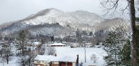
No freezing fog at the house this morning. It's currently 25 which is my low. Snow makers are busy up at Cataloochee and Tube World here in town. I'm not expecting much from the system coming in overnight into tomorrow. Late this week we are likely to get the coldest air of the season as lobes of Arctic air heads our way. It's too soon to know if we will have precipitation arriving with the Arctic front. -
2025-2026 Fall/Winter Mountain Thread
Maggie Valley Steve replied to Buckethead's topic in Southeastern States
Currently 30 with frost. -
2025-2026 Fall/Winter Mountain Thread
Maggie Valley Steve replied to Buckethead's topic in Southeastern States
Anyway, skies have cleared and the temperature has dropped 5F the past hour. Currently 37 at 5 o'clock. -
2025-2026 Fall/Winter Mountain Thread
Maggie Valley Steve replied to Buckethead's topic in Southeastern States
Maggie Valleys average is 8 to 10 inches a year. I've surpassed for the last 6 years and already well on the way to surpass the average again this winter. We need a big synoptic storm Region wide to calm the Mountain envy! -
2025-2026 Fall/Winter Mountain Thread
Maggie Valley Steve replied to Buckethead's topic in Southeastern States
That's simply not true. I've averaged over 8 inches every year for the last 6 years and have even seen a couple of years over 25 inches. I bet Buckethead has been above average as well. -
2025-2026 Fall/Winter Mountain Thread
Maggie Valley Steve replied to Buckethead's topic in Southeastern States
The 12Z GFS remains aggressive for a nice little event Sunday night/Monday/early Tuesday..thumb.png.cde71be4ba36dbae733bf48b5a53b8e5.png)
-
2025-2026 Fall/Winter Mountain Thread
Maggie Valley Steve replied to Buckethead's topic in Southeastern States
Woke up to a low of 34 here in the Valley at 3200ft. Looks like Cataloochee dropped to 33 with light rain. Warm nose saved us for this event. Keeping an eye on Sunday afternoon into Monday for another shot of wintry weather. I see DC has snow this morning. Good for them. -
2025-2026 Fall/Winter Mountain Thread
Maggie Valley Steve replied to Buckethead's topic in Southeastern States
38 and light rain currently. -
2025-2026 Fall/Winter Mountain Thread
Maggie Valley Steve replied to Buckethead's topic in Southeastern States
Stuck at 41 after a low of 26. Wet bulb is 28 with a DP of 19. Radars from Morristown and Nashville are juicy! -
We Mountain folks are pulling for you guys! Don't give up, it's December 3rd and we aren't even into prime time climo wise for the Region!
-
2025-2026 Fall/Winter Mountain Thread
Maggie Valley Steve replied to Buckethead's topic in Southeastern States
Looking like a Winter Weather Advisory will be hoisted tomorrow for Thursday night into Friday morning across the Mountains. GSP in their Hazardous Weather Outlook is mentioning snow tomorrow night mixing with sleet/freezing rain/rain Friday morning as the warm nose builds in during the daylight hours of Friday. -
2025-2026 Fall/Winter Mountain Thread
Maggie Valley Steve replied to Buckethead's topic in Southeastern States
Snow flurries in the Valley. It's starting to stick on the deck and vehicles. 31 and no wind. -
2025-2026 Fall/Winter Mountain Thread
Maggie Valley Steve replied to Buckethead's topic in Southeastern States
Yes Sir! I never expected anything but plain old rain here with this system. It's already sprinkling here at 3200 ft. -
December 2025 Short/Medium Range Forecast Thread
Maggie Valley Steve replied to John1122's topic in Tennessee Valley
I'm sure you folks are aware of another SSW Event unfolding for mid month? -
2025-2026 Fall/Winter Mountain Thread
Maggie Valley Steve replied to Buckethead's topic in Southeastern States
Temperature has actually gone up the past hour here at the house. Was 42 now it's 45. -
2025-2026 Fall/Winter Mountain Thread
Maggie Valley Steve replied to Buckethead's topic in Southeastern States
I see another SSW event is ahead in a couple of weeks. Let the model mayhem continue! -
2025-2026 Fall/Winter Mountain Thread
Maggie Valley Steve replied to Buckethead's topic in Southeastern States
It's going to be a close call here in Haywood County overnight. I see GSP has issued a Winter Weather Advisory for Buncombe and Henderson Counties now. Frankly the models are struggling beyond 24 to 48 hours. Until they settle down, it's hard to put much faith in the medium and longer range guidance. -
2025-2026 Fall/Winter Mountain Thread
Maggie Valley Steve replied to Buckethead's topic in Southeastern States
GSP mentioned Winter Weather Advisory coming either later this afternoon or tomorrow morning for all of the Mountain areas including the SW Mountains for tomorrow night. Looks like snow changing to freezing rain event. They are also mentioning the next event would be Thursday night into Friday with snow likely for all areas including Asheville/Hendersonville before changing to sleet/freezing rain. The upcoming medium range continues to advertise a fast progressive pattern with moisture every day or two into next week. -
Mid to long range discussion- 2025
Maggie Valley Steve replied to wncsnow's topic in Southeastern States
The last time before last year the Gulf Coast witnessed that type of snow event was 1899 and somewhat 1895. That tells you just how historic last year was! -
2025-2026 Fall/Winter Mountain Thread
Maggie Valley Steve replied to Buckethead's topic in Southeastern States
The Friday afternoon update from the Climate Prediction Center suggests we stay cold and wet until the 26th of December. It's been a while since I've seen them this bullish on cold and wet for an extended period during the winter. -
2025-2026 Fall/Winter Mountain Thread
Maggie Valley Steve replied to Buckethead's topic in Southeastern States
Welcome! Glad to have you in our great group of Mountain posters! May there be many 'Jebwalks' in your future! -
2025-2026 Fall/Winter Mountain Thread
Maggie Valley Steve replied to Buckethead's topic in Southeastern States
17 this morning in the Valley. We could see a bit more widespread NWFS Sunday evening. Another chance on Tuesday night .

.png.d2823165dddbb7e42894683ae76f38a9.png)
.png.57d5d0d4bd09f77675e6350377c02840.png)
.png.b51b71007800fbd025524d151ccca91f.png)
