-
Posts
4,951 -
Joined
-
Last visited
Content Type
Profiles
Blogs
Forums
American Weather
Media Demo
Store
Gallery
Everything posted by Stormchaserchuck1
-
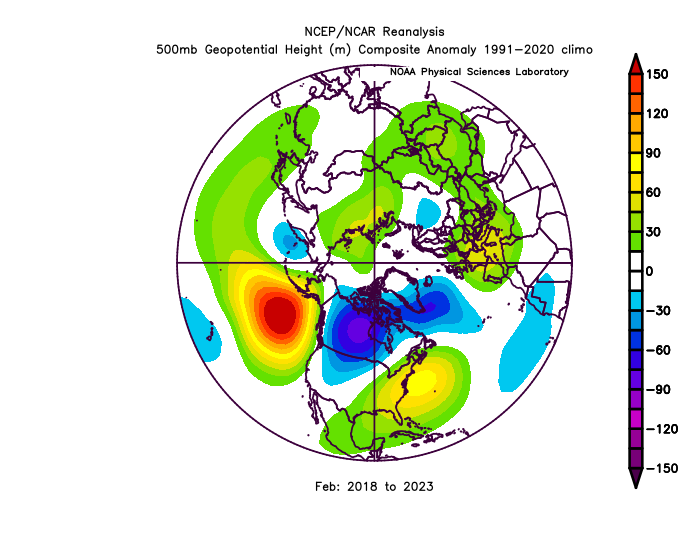
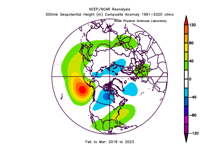
Not only that, but the warmth seems to be accelerating! Since the satellite era in 1948, the N. Pacific Ocean High pressure for Feb-March (-PNA) is going to be after this March, a whole +25% over any 500mb anomaly on record (for a 2-month period, spanning 7 years). But perhaps a side point is, that is a pattern. It's not random, general warming happening, it's something causing -PNA's to be more frequent in Feb-March. I would put money on next Feb-March also featuring this -PNA, SE ridge pattern.
-

Winter 2023-2024
Stormchaserchuck1 replied to Stormchaserchuck1's topic in Weather Forecasting and Discussion
Here's your -AO look: I thought a Strong El Nino/Strong -QBO combo would do that.. we had a few Stratosphere warmings. The Pacific Ocean pattern kept North America warmer.. -

Would you bet against +PNA February?
Stormchaserchuck1 replied to Stormchaserchuck1's topic in Mid Atlantic
I nailed it.. there was more -PNA in February than +PNA The big Aleutian low that models were showing ended up in the Bering Strait, which isn't really the same thing. Persistence won. -

Late Feb/March Medium/Long Range Discussion
Stormchaserchuck1 replied to WinterWxLuvr's topic in Mid Atlantic
I think the rotation of the Earth has slowed a little.. we are seeing more High pressure systems. land vs water friction also seems to be a little greater (cold coming more from Canada vs 50/50 low cold). -

Late Feb/March Medium/Long Range Discussion
Stormchaserchuck1 replied to WinterWxLuvr's topic in Mid Atlantic
The PDO talk drives me crazy. It's not some independent thing, It's feedback from previous patterns. Air is so much lighter than water, so it changes first.. then the water warms/cools. All that's being spotted with the PDO is pattern marks, some alternate mechanism, unless the Pacific rim is active or something.. -

Late Feb/March Medium/Long Range Discussion
Stormchaserchuck1 replied to WinterWxLuvr's topic in Mid Atlantic
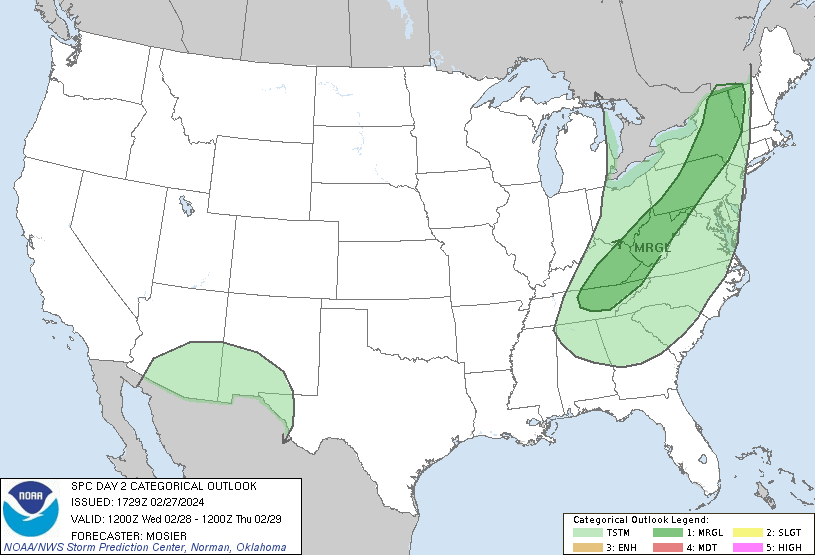
It looks like we're going to be too far south for severe wx tomorrow.. an El Nino February Chicago's under a tornado watch, and the radar looks impressive there -

Late Feb/March Medium/Long Range Discussion
Stormchaserchuck1 replied to WinterWxLuvr's topic in Mid Atlantic
CPC is pretty big on the +EPO pattern sticking around https://ibb.co/37rmSNg -

El Nino 2023-2024
Stormchaserchuck1 replied to George001's topic in Weather Forecasting and Discussion
It did. https://origin.cpc.ncep.noaa.gov/products/analysis_monitoring/ensostuff/ONI_v5.php Since 1948, The 4 times we had a OND ONI +2.0 or greater, we had a La Nina the following OND. One of those was the strongest La Nina on record (1973). -

Late Feb/March Medium/Long Range Discussion
Stormchaserchuck1 replied to WinterWxLuvr's topic in Mid Atlantic
I thought it was telling when Boston only had 2" of snow in the core of Winter, I think it was either 17-18, or 19-20. The jet stream has been lifting north for sure.. -

Late Feb/March Medium/Long Range Discussion
Stormchaserchuck1 replied to WinterWxLuvr's topic in Mid Atlantic
12z GFS ensembles trended much more -NAO, starting the first few days of March. We had a minor Stratosphere warming Feb 15-23, so the beginning of March actually fits the average lag for warmings at this time of year.. interesting that standard methods would have got it right, and not models until now.. problem for snow/cold is the Pacific pattern is bad for the foreseeable future.. -

Late Feb/March Medium/Long Range Discussion
Stormchaserchuck1 replied to WinterWxLuvr's topic in Mid Atlantic
18z GEFS tries to develop a west-based -NAO block by mid-March. Let's see if the Pacific pattern breaks down shortly after.. I think if we have a big -NAO develop, the Pacific will correlate and -PNA/+EPO will prevail.. -

El Nino 2023-2024
Stormchaserchuck1 replied to George001's topic in Weather Forecasting and Discussion
Very interesting that, that's when the N. Pacific High has been fluxing: This 7-year trend now, is record breaking ('64-69 -NAO comes in 2nd, at 80% of the anomaly). 2-months including March is also record breaking for a 6/7 year stretch. -

Late Feb/March Medium/Long Range Discussion
Stormchaserchuck1 replied to WinterWxLuvr's topic in Mid Atlantic
Yeah, PDO's usually go in the direction of ENSO state like 85% of the time. Another thing too is, this La Nina is already heavily supporting -PNA.. Since the subsurface cooled, and the SOI flipped, this new High pressure pattern took over in the N. Pacific. so if that trend continues through the Spring and Summer, which I think it will, the PDO should drop further. -
The crazy thing about this map and us being the 3rd warmest is, it looks like it's a -AO pattern! It was once theorized that AO was our #1 pattern for warm and cold, but there have been some warm -AO's the last few Winters.. I think the key these days is more on the Pacific side. The circulation between the Poles and the mid-latitudes seems to have quieted down some.. it's more about having more low pressures around the Earth at your latitude.
-
The thing about the expanded Hadley Cell is, what's causing it? For the Hadley cell to expand, another cell has to contract. You could say that the +AMO and -PDO favor more mid-latitude High pressures. I also think it could come from more La Nina patterns that we have seen (almost 2:1), since sunspots started quieting down in the 1990s? In global warming, the poles are hit the hardest, but it seems like a La Nina pattern to me. That doesn't mean general warming still isn't occurring.. it is, and actually, almost exponentially.
-
Here is what I accidentaly posted in the long range thread.. I left it there because PSUhoffman replied quoting it. I think the reason for less clippers and Miller A's is lack of +PNA, although even when that pattern is present, those two storm types are happening about 30% less of the time. Basically.. I don't have a good answer for you. The pattern has been more zonal, vs major troughs.. now, the -PNA that we have seen since 1998 and then 3x more since 2016 is a real anomaly, and not a product of global warming.
-
We had a minor 10mb warming Feb 15-23 The estimated time to impact, March 3-10, looks very warm on current models in the Eastern, US (No +NAO though, it's because of +EPO/-PNA). We may get cold shots in the West during that time. This was our 3rd 10mb warming event of the Winter season. I believe models were showing a 4th warming event starting after ~March 5.
-

Late Feb/March Medium/Long Range Discussion
Stormchaserchuck1 replied to WinterWxLuvr's topic in Mid Atlantic
Oops.. I meant to post it in the other thread. Oh well, might as well say that until that trough moves from Alaska, we will be in the 50s and 60s. Good news is LR models haven't been great this year. -

Late Feb/March Medium/Long Range Discussion
Stormchaserchuck1 replied to WinterWxLuvr's topic in Mid Atlantic
I think the reason for less clippers and Miller A's is lack of +PNA, although even when that pattern is present, those two storm types are happening about 30% less of the time. -

2024-2025 La Nina
Stormchaserchuck1 replied to George001's topic in Weather Forecasting and Discussion
For the next 2 weeks, there is an impressive High pressure setting up in the N. Pacific Ocean. The strength is going to rival some of the strongest on record. This pattern started, imo, when the cold water moved into the central-ENSO-subsurface. The SOI being super negative was holding the pattern back for a while, but when that moderated, the major pattern moved into the N. Pacific Ocean. It seems to be super-connected to the La Nina early, so I don't see why that wouldn't last through the event, and maybe even with such a strong correlation that it holds the strength of the coming La Nina down some. With the 500mb conditions in the N. Pacific that have occurred Feb-March 2018-2024, breaking high anomaly records in other times by +20-25%, it's easy to formulate that we are at the peak of this "global La Nina cycle", or some are calling it the -PDO, or +AMO. The -PNA pattern held in the Summer/Fall through a lot of the Strong El Nino last year, breaking the strong-ENSO correlation we had, had for many decades, so it will be interesting to see what happens going back to the opposite ENSO state this year. La Nina's have been hitting on N. Pacific pattern correlation, El Nino's have not been. -
Lol, yeah, we have a really hot Summertime pattern setting up now. It's connected to the La Nina early, so my thoughts is it will continue if the La Nina does continue to develop.
-

2024-2025 La Nina
Stormchaserchuck1 replied to George001's topic in Weather Forecasting and Discussion
Better start breeding those butterflies in Africa.


.png.6058b31aa027a32cb19557edd2942d59.png)
.gif.1e28b6641b65e55eef9129f00ca0568c.gif)


.gif.3de8112b7c845eb6c09b3a07154caeb9.gif)