Hurricane Agnes
-
Posts
9,263 -
Joined
Content Type
Profiles
Blogs
Forums
American Weather
Media Demo
Store
Gallery
Everything posted by Hurricane Agnes
-
E PA/NJ/DE Winter 2022-2023 OBS Thread
Hurricane Agnes replied to Ralph Wiggum's topic in Philadelphia Region
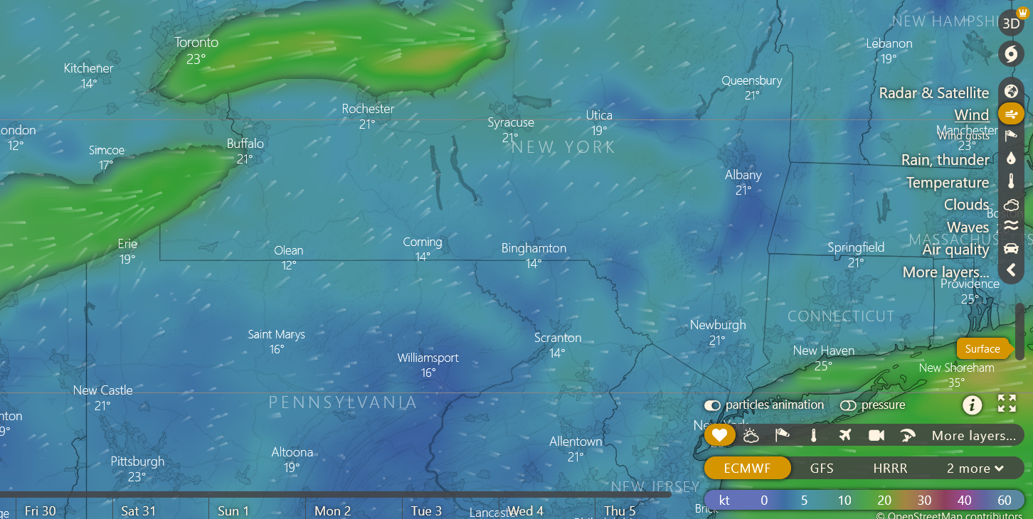
ANNNDDDDD.... the Dense Fog Advisory has now been extended to 2 pm. Not as bad as earlier but still under 1/10th of a mile here. Temp is 53 with dp 53. -
E PA/NJ/DE Winter 2022-2023 OBS Thread
Hurricane Agnes replied to Ralph Wiggum's topic in Philadelphia Region
Dense Fog Advisory extended to noon (and that's good because the fog seems to have gotten even denser here in NW Philly) - Current temp is 51 with dp 51. -
E PA/NJ/DE Winter 2022-2023 OBS Thread
Hurricane Agnes replied to Ralph Wiggum's topic in Philadelphia Region
Geez. Hope you guys take it easy get better. I know there are all kinds of respiratory things going around. Probably universal to suggest plenty of fluids although I expect some adult types of "fluids" might be on tap for the Iggles tomorrow. I did make it up to 57 as a high yesterday and this morning, in the midst of literal pea-soup fog with visibility < 1/10th of a mile (and I saw a Dense Fog Advisory was lofted), I have had a low of 48 so far. Currently foggy and 50 with dp 50. Also Mt. Pocono had a Record high min yesterday. lol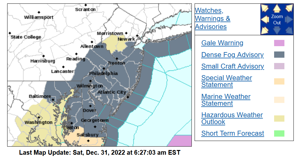
-
E PA/NJ/DE Winter 2022-2023 OBS Thread
Hurricane Agnes replied to Ralph Wiggum's topic in Philadelphia Region
A LOL @ this (going from record lows climo section to record highs climo section) - I did make it up to 46 as a high yesterday and possibly have a low this morning of 28 as it's currently 29 with dp 25. -
E PA/NJ/DE Winter 2022-2023 OBS Thread
Hurricane Agnes replied to Ralph Wiggum's topic in Philadelphia Region
At least that was a rare powdery snow (temp was in the low 20s where I was much of the event) and when I made it out to start digging the car out, because of where I had parked it in my apt. complex lot, the only place on it with snow was the front bumper. No joke. The rest had been blown off by the wind and the car had been mostly protected by the building too. Still had to trudge down the middle of the street to walk to the supermarket with one of those grocery carts to get the usual milk and bread that I previously laughed at people buying beforehand (on my birthday even, as the storm had just ended and the sun came out) and was greeted with 6 ft plowed mounds on both sides of the street and a couple cars stuck after getting stalled and buried on one part of the street. -
E PA/NJ/DE Winter 2022-2023 OBS Thread
Hurricane Agnes replied to Ralph Wiggum's topic in Philadelphia Region
I made it up to a high of 36 yesterday and after a low of 28 this morning, am already up to 40 and rising steadily. Currently mostly sunny with some cirrus and dp at 27. -
E PA/NJ/DE Winter 2022-2023 OBS Thread
Hurricane Agnes replied to Ralph Wiggum's topic in Philadelphia Region
You were looked for as some were worried! It's not good (or safe) up there with some of the restrictions in place. -
E PA/NJ/DE Winter 2022-2023 OBS Thread
Hurricane Agnes replied to Ralph Wiggum's topic in Philadelphia Region
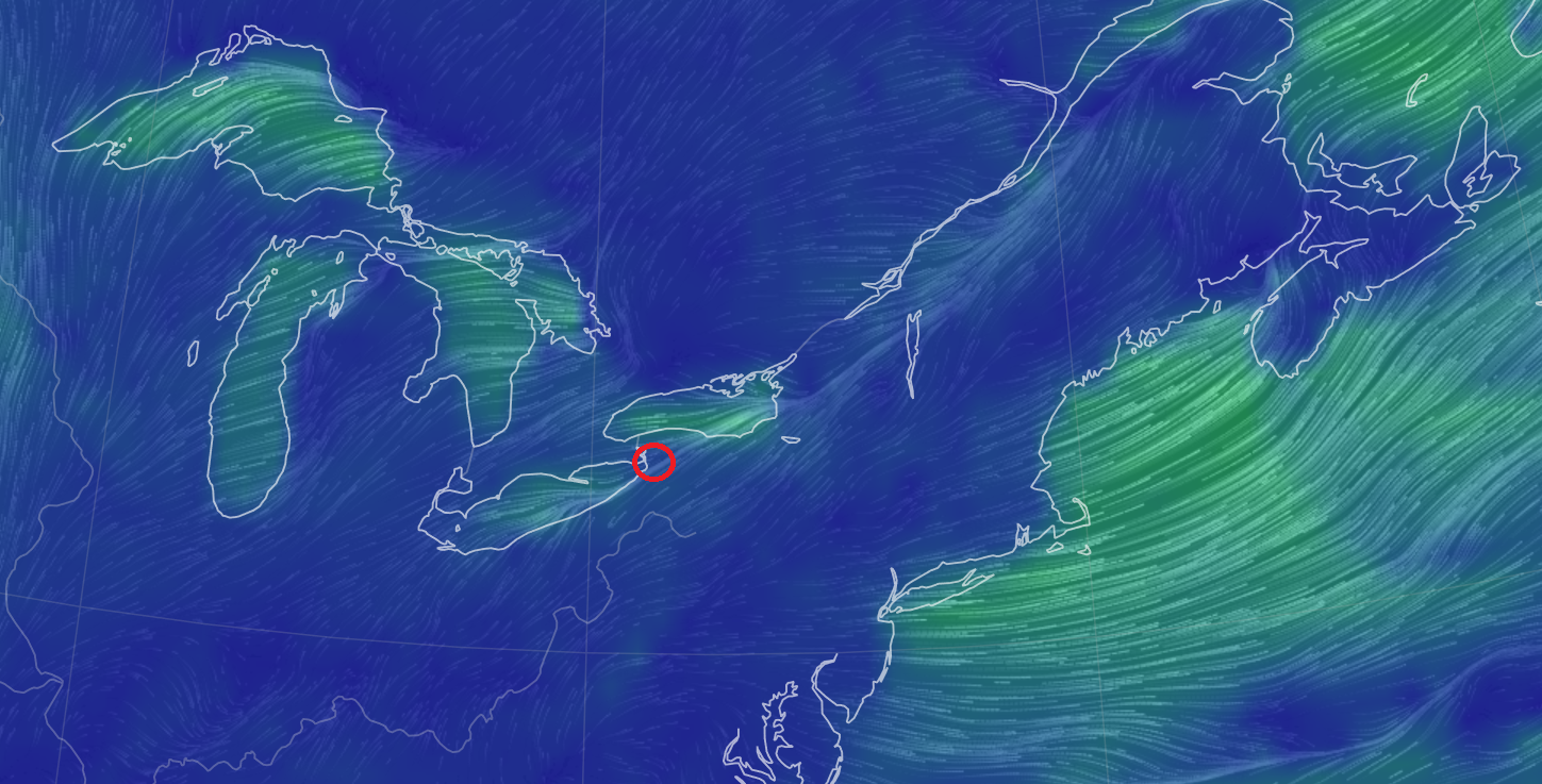
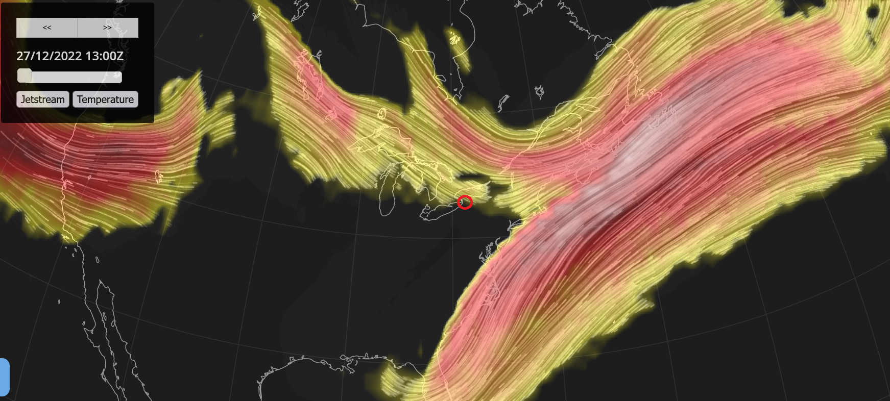
That low that bombed out and went up into Canada is still up there as a 992 and that plus the northern jetstream are in positions that are still funneling arctic winds over Lake Erie, hitting Buffalo hard and over an extended period of time (it's snowing up there right now at post time). The lakes were only minimally ice covered before that arctic blast came in so that made conditions ripe for a huge lake effect event in those areas where the wind direction hits the right way. As for IMBY, I seemed to have kept cloud cover overnight so the low was 26 and I'm currently overcast and 28 with dp 17.


-
E PA/NJ/DE Winter 2022-2023 OBS Thread
Hurricane Agnes replied to Ralph Wiggum's topic in Philadelphia Region
Had a low of 15 this morning and made it up to 28 as a high, which is the 3rd consecutive day when it didn't reach or go above freezing (starting 12/24). It's currently 27 and overcast, with dp still dry at 13 (giving my humidifiers a workout). -
This sis and her neighbor are in Wyndmoor. I know the neighbors on the block were giving them a hand (my niece and the neighbor's daughter had been texting back and forth after it happened). I was at my sister's house last night and had asked about any status updates and she was thinking they may be staying in a hotel for now (am not sure if they have family nearby - I have met the neighbor's daughter many times when she would visit my niece when I was over there). Am surprised (but shouldn't be) that the temp has stabilized overnight and has been hanging around 14. Currently clear and 14 with dp a balmy 7.
-
I got it too. I mentioned upthread when I heard on KYW earlier this afternoonas well. They are claiming their equipment isn't' handling the big temp drop this early in the season. I am also thinking that winter is usually when they do maintenance so they probably also have some facilities offline so they can't handle the extra load (along with the storm wreaking havoc to the grid with downed lines, etc) in other parts of the state. One of my sister's neighbors literally lost her house to a fire last night due to a fallen tree that brought down wires and then a power surge literally fried the house insulation and the whole house went up in flames.
-
Hope you have a joyous Christmas and also hoping PJM doesn't start the rolling blackouts (as I heard this afternoon on KYW ) Looks like my high may end up being the 14 that it's been hanging at for the past few hours. The low this morning ended up being 5. It's currently a breezy 14 with dp 0. PHL will definitely break a record today for coldest high for Christmas Eve day (when I checked earlier this afternoon, they had made it up to 17 but are now down to 16) - They also did a climo site temp change chart (I know Don has been adding that to-
-
My current just dropped to 5 (dp -7). That is some serious cold this early in the season! I had pooh-poohed some of the models showing single digits here in the city (due to it being December and not January or February) but right now PHL is at 8.
-
Well my station "officially" registered a 50 degree temp drop in under 22 hours. So far I am currently at 6 with dp -5 (my deep freezer that cycles on and off and has a sensor in it so I can track it, is currently at -6 (it cycles down to about -14 or so).
-
Now down to 8 with dp -4. Last time I hit single digits was back on February 1, 2019 (definitely nothing like that in December), with the same temp.
-
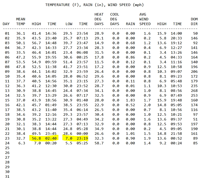
My high early this morning (~2:40 am) was 57 and I am at 10 right now, a 47 degree drop!
-
Humidity in my house went from ~38% (with humidifiers or with the rains yesterday/today) down to 25% (with them off and the end of the rain). Literally just filled my big one and turned it on. Am now down to 10 and the dp is -2.
-
Even with this wind, am at 11, a temp you'd expect with good radiational cooling! DP is currently -1.
-
Can't make french toast then! Well my temp hit the mid-teens well before the 7 pm estimate as it's currently 15 with dp 4. I had turned off the humidifiers during the rain but time to fire them up because I expect the dp may end up in the negative single digits and I'm not partial to zapping myself walking through the house.
-
Yikes! I know there are a bunch of dead and half-dead trees in the woods near my house (you could tell during the summer when their tops were leafless and some of the branches had leaves and others didn't). I wouldn't be surprised if any of those snapped (although as long as they fall within the woods line, then the impact is minimal to none). Currently partly sunny with changeable skies, breezy, and now down to 21 with dp 9.
-
Down to 23 with dp 13 as the arctic air mass means some business. Have changeable skies and lots of wind. It has dried off the walks.
-
Sun out. Final rain total was 0.90" for today (2-day 1.91"). Got a light dusting on grassy surfaces, house roofs, and car tops - much of it disintegrating now. Currently partly sunny and temp is 26 with dp down to 20. I know I'll lose about 10 more degrees off of that by tonight.
-
Back edge is coming through and the sky is brightening. Temp now 26 with dp 25.
-
Temp now down to 27 (dp 26) with an increase of snow back to SN here and finally getting some stickage on the grass and cars. Still a dusting but it's definitely there.
-
Down to SN- and the only places that have a sign of frozen is a little dusting in random parts of the mulch outside my door (so far). Nothing on grassy areas or cars. Temp down below freezing at 31 with dp 30.