Hurricane Agnes
-
Posts
9,344 -
Joined
Content Type
Profiles
Blogs
Forums
American Weather
Media Demo
Store
Gallery
Everything posted by Hurricane Agnes
-
E PA/NJ/DE Winter 2022-2023 OBS Thread
Hurricane Agnes replied to Ralph Wiggum's topic in Philadelphia Region
My Upper Darby sister texted that she is at 70 there now. I am at 64 so delayed but not denied. A NBC10 met who popped in on KYW earlier noted that there was some easterly wind component today that had been keeping some of the temps down so far (particularly at the shore), but the 70s were definitely going down in the Delmarva. Missed who it was. EDIT - after missing 2 more reports I finally caught which met was reporting into KYW this afternoon - Michelle Rotella. -
E PA/NJ/DE Winter 2022-2023 OBS Thread
Hurricane Agnes replied to Ralph Wiggum's topic in Philadelphia Region
Wow. Small world. I found a video someone posted showing some of the damage. Adding updated PNS issued yesterday afternoon. Right now I'm up to 59 with dp 49 and sunny. -
E PA/NJ/DE Winter 2022-2023 OBS Thread
Hurricane Agnes replied to Ralph Wiggum's topic in Philadelphia Region
I'm up to 49 now and slowly going up. I think I'm probably around 15 miles south of you. -
E PA/NJ/DE Winter 2022-2023 OBS Thread
Hurricane Agnes replied to Ralph Wiggum's topic in Philadelphia Region
The fog has lifted and the sun just popped out here, with the sky clearing rapidly and temp going up. I think the warm front is finally on the move. Currently mostly sunny and 48 with dp 44. -
E PA/NJ/DE Winter 2022-2023 OBS Thread
Hurricane Agnes replied to Ralph Wiggum's topic in Philadelphia Region
Forecast was for the front to finally pop up and off the mountains by the early afternoon. Currently still in the 30s/40s in the CWA.
-
E PA/NJ/DE Winter 2022-2023 OBS Thread
Hurricane Agnes replied to Ralph Wiggum's topic in Philadelphia Region
Wow, I think maybe the warm front is on the move and although the temp here hasn't gone up yet, the fog has rolled in like mad from the north. Vis down to about 1/10th of a mile. I ended up with a high of 44 and 0.02" of precip yesterday despite all the stuff that blew overhead. Currently a damp and foggy 40 after a low of 39 and with dp 40. -
E PA/NJ/DE Winter 2022-2023 OBS Thread
Hurricane Agnes replied to Ralph Wiggum's topic in Philadelphia Region
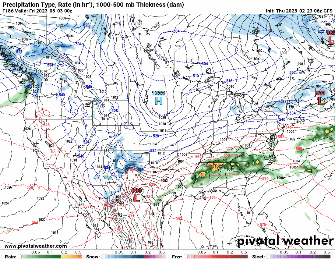
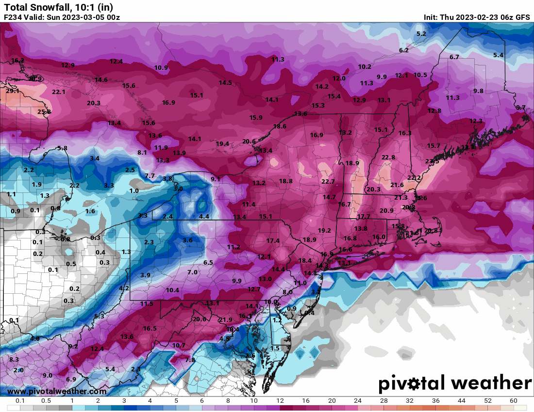
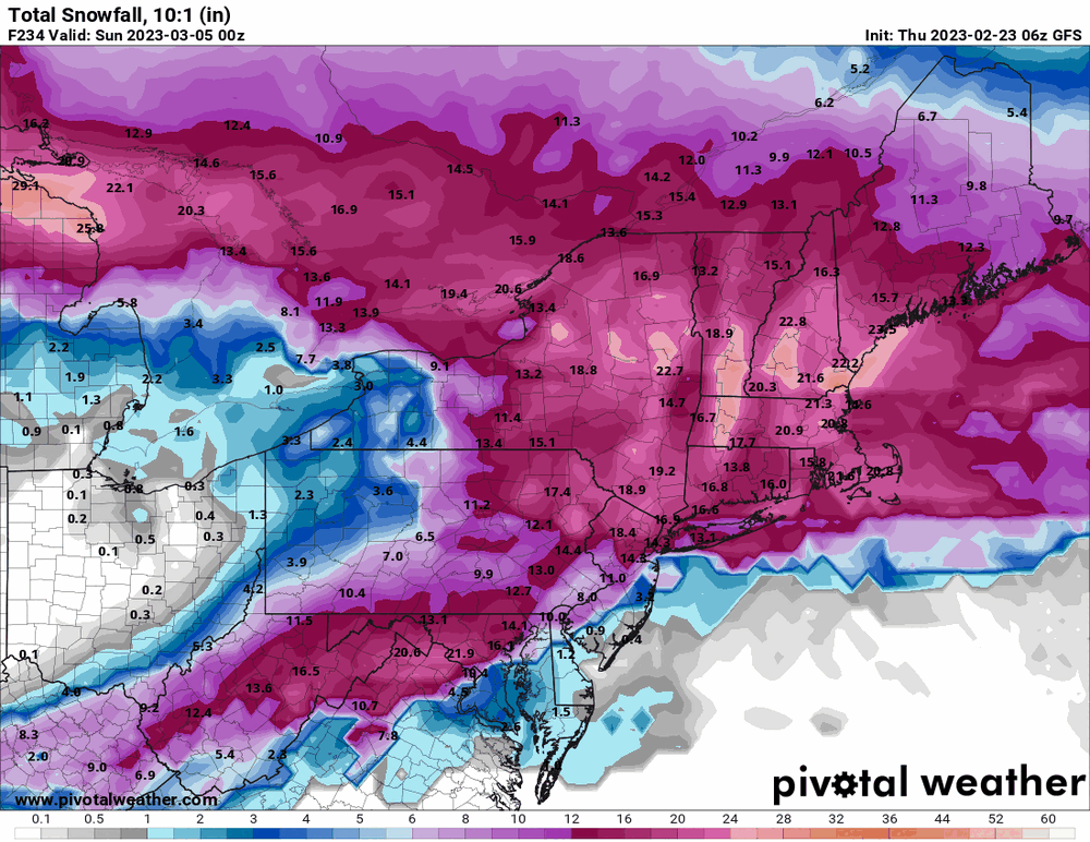
Zooming in on that map, I can sortof see where stemwinder would be north of that path. Still too close!!! And the 6z GFS has a coastal thing for that March 4 - 5 frozen.
-
E PA/NJ/DE Winter 2022-2023 OBS Thread
Hurricane Agnes replied to Ralph Wiggum's topic in Philadelphia Region
Currently getting very light rain and drizzle here (not enough to be measurable yet) but no pingers. Temp currently 43 with dp 30. But you won't have to use it until the March/April frosts and freezes that will be just in time for when my blueberries are blooming, guaranteeing a perfect kill!!! -
E PA/NJ/DE Winter 2022-2023 OBS Thread
Hurricane Agnes replied to Ralph Wiggum's topic in Philadelphia Region
It had cleared enough here oveernight and early this morning to drop me down to 31 for a low just before 5:30 am. It started out partly sunny earlier but has clouded up much of the rest of the morning. Currently overcast and 42 with dp 30. -
E PA/NJ/DE Winter 2022-2023 OBS Thread
Hurricane Agnes replied to Ralph Wiggum's topic in Philadelphia Region
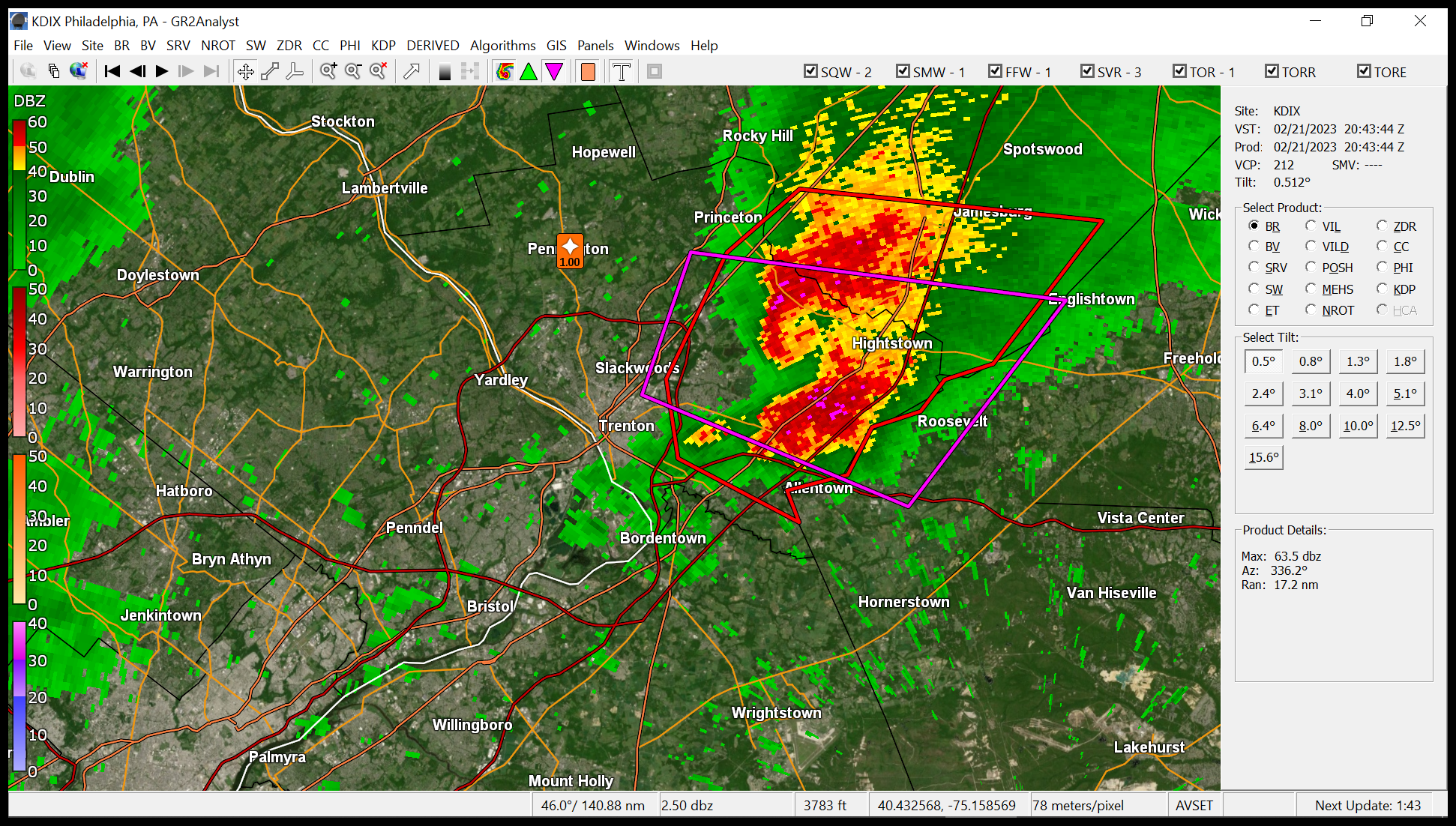
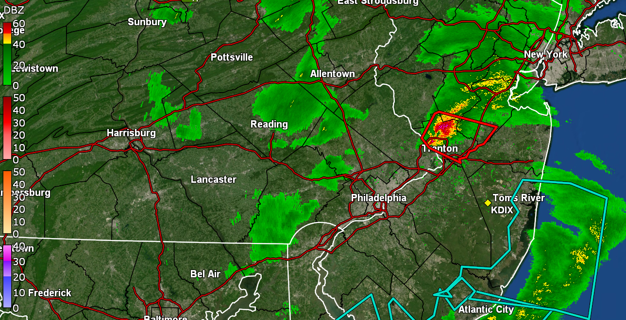
Mt. Holly preliminary assessment did confirm a tornado with details to come later. PNS - -
E PA/NJ/DE Winter 2022-2023 OBS Thread
Hurricane Agnes replied to Ralph Wiggum's topic in Philadelphia Region
You appear to possibly be in the NWS "survey area" for the suspected tornado! Map from the NWS tweet - -
E PA/NJ/DE Winter 2022-2023 OBS Thread
Hurricane Agnes replied to Ralph Wiggum's topic in Philadelphia Region
Survey teams for the possible tornado in Jersey will be out tomorrow - Meanwhile, I ended up with a couple hundredths of an inch on top of the morning rain and have 0.19" rain so far today. Current temp is down to 43 with dp 37. -
E PA/NJ/DE Winter 2022-2023 OBS Thread
Hurricane Agnes replied to Ralph Wiggum's topic in Philadelphia Region
TOR expiring soon although it may have already been dropped. Just popped outside and there is some weird mixing winds with the cool air being felt and a bit of a dp drop. Currently 55 with dp 39. -
E PA/NJ/DE Winter 2022-2023 OBS Thread
Hurricane Agnes replied to Ralph Wiggum's topic in Philadelphia Region
Something spun up.
-
E PA/NJ/DE Winter 2022-2023 OBS Thread
Hurricane Agnes replied to Ralph Wiggum's topic in Philadelphia Region
Had 0.17" rain with round 1 this morning and have been watching as stuff has passed overhead but no precip. yet. The lightning detector did pick up some strikes so the convection is definitely out there and I saw STS up over in Jersey. After a 40 low, currently changeable skies (with some storm clouds looking west) and 57 with dp 42.
-
E PA/NJ/DE Winter 2022-2023 OBS Thread
Hurricane Agnes replied to Ralph Wiggum's topic in Philadelphia Region
Have been progressively warming up since the weekend after a Sat. 26 low/41 high and a Sun. 31 low and 52 high. Today's low was 43 and I got up to a comfortable 62 for a high. Have had an unsettled day with clouds and sun. Was expecting it to rain earlier and it was delayed but not denied, with some non-measurable at post time (walk is wet). Currently damp and 55 with dp 40. -
E PA/NJ/DE Winter 2022-2023 OBS Thread
Hurricane Agnes replied to Ralph Wiggum's topic in Philadelphia Region
Rather obvious fropa. Ended up with a misty shower with it for another 0.01" for 0.55" for today (at least so far). Temp has settled at 48 after shooting up to 60. Dp is 45.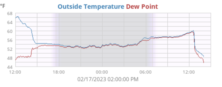
-
E PA/NJ/DE Winter 2022-2023 OBS Thread
Hurricane Agnes replied to Ralph Wiggum's topic in Philadelphia Region
Had 0.54" of rain this morning (0.71" over 2 days) and now am hearing the winds of the cold front. My "low" was 53 earlier this morning and I hit 60 just before the gust front and them temp is now rapidly dropping and down to 56 at post time with dp 55. -
E PA/NJ/DE Winter 2022-2023 OBS Thread
Hurricane Agnes replied to Ralph Wiggum's topic in Philadelphia Region
I made it up to 67 for a high after a 48 low. Ended up getting 0.21" of rain with this round 1 (it didn't start until sometime just before 2 pm. It's currently mostly cloudy and 53 with dp 53. -
E PA/NJ/DE Winter 2022-2023 OBS Thread
Hurricane Agnes replied to Ralph Wiggum's topic in Philadelphia Region
Yup. It definitely caught my attention and I believe it is associated with some atmospheric turbulence. Based on the timing of it, I *think* that may have happened when a warm front was wobbling in the area and there was some mixing going on up high. I had a screenshot of what the temp/humidity did right around then and both suddenly did a hiccup and stabilized.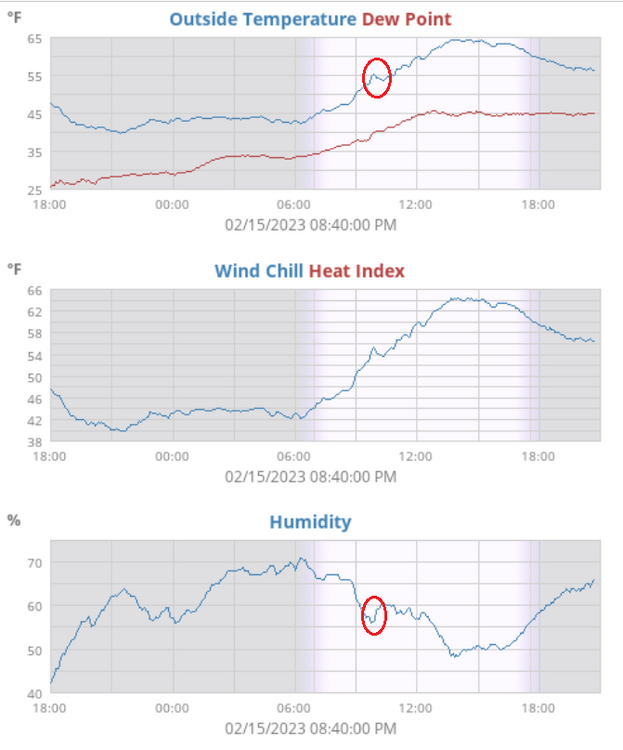
-
E PA/NJ/DE Winter 2022-2023 OBS Thread
Hurricane Agnes replied to Ralph Wiggum's topic in Philadelphia Region
I had texted one of my sisters yesterday about seeing some early forsythia blooming in my neighborhood and how I had a work trip about 20 years ago to San Francisco in February - left Philly in snow boots with the remnants of 8" of snow on the ground and got there to find temps in the 60s during the day and 40s at night (only needed a sweater). They had tulips blooming at their annual "Tulipmania" Festival at Pier 39 (didn't even know that was a "thing") and this was near the end of February (apparently considered a bit "early" back then but now they have pushed the festival earlier and earlier over the years since). This was an article from the year that I was there - https://www.sfgate.com/bayarea/article/Tulips-spring-to-life-early-this-year-Pier-39-s-2631698.php I know that England also gets those early bulb blooms as a matter of course for their Gulf Stream climate. Am currently mostly cloudy about a half hour before sunrise and am at my low of 49 at the moment with dp 42. The winds have gone calm so may drop a few more degrees. -
E PA/NJ/DE Winter 2022-2023 OBS Thread
Hurricane Agnes replied to Ralph Wiggum's topic in Philadelphia Region
I had some stratus earlier and then some funky Monet-like impressionist clouds that are apparently called asperitas (a new cloud designation as of 2009) - https://www.theguardian.com/environment/gallery/2009/jun/01/2?picture=348217732 This type (above is an example) were off to the west some time this morning around 9:45ish am. -
E PA/NJ/DE Winter 2022-2023 OBS Thread
Hurricane Agnes replied to Ralph Wiggum's topic in Philadelphia Region
After a low of 41 this morning I made it up to 65. Expecting a similar high tomorrow too. It was unsettled today though with threatening stratus clouds coming and going much of the day. -
E PA/NJ/DE Winter 2022-2023 OBS Thread
Hurricane Agnes replied to Ralph Wiggum's topic in Philadelphia Region
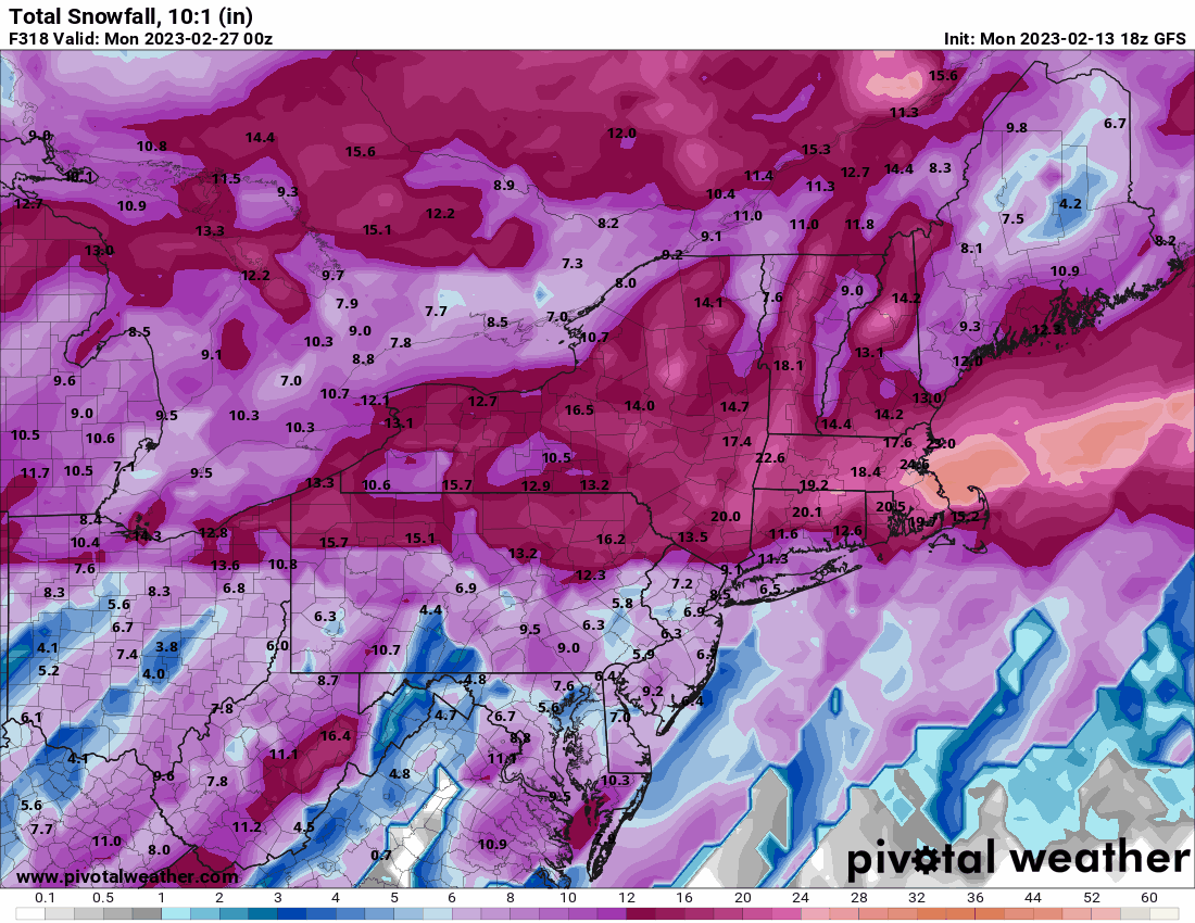
After a 39 low this morning I made it up to 57 for a high. Ended up getting 0.17" of rain yesterday which was the first measurable recorded for the month so far (other times there was enough to wet the walks but not tip the bucket). Currently 48 with a dryish dp of 21 (I saw SPSs up for the N/W burbs for fire potential weather issues). And 18z GFS - end of month frozen from what looks like a fropa. Lock and load.
-
E PA/NJ/DE Winter 2022-2023 OBS Thread
Hurricane Agnes replied to Ralph Wiggum's topic in Philadelphia Region
My "low" for yesterday ended up being 43 just before midnight last night and the low today (so far) was 36 about an hour ago. Currently mostly sunny and 38 with dp down to 21 (thanks to that earlier CFP).