Hurricane Agnes
-
Posts
9,344 -
Joined
Content Type
Profiles
Blogs
Forums
American Weather
Media Demo
Store
Gallery
Everything posted by Hurricane Agnes
-
Yikes! I know there are a bunch of dead and half-dead trees in the woods near my house (you could tell during the summer when their tops were leafless and some of the branches had leaves and others didn't). I wouldn't be surprised if any of those snapped (although as long as they fall within the woods line, then the impact is minimal to none). Currently partly sunny with changeable skies, breezy, and now down to 21 with dp 9.
-
Down to 23 with dp 13 as the arctic air mass means some business. Have changeable skies and lots of wind. It has dried off the walks.
-
Sun out. Final rain total was 0.90" for today (2-day 1.91"). Got a light dusting on grassy surfaces, house roofs, and car tops - much of it disintegrating now. Currently partly sunny and temp is 26 with dp down to 20. I know I'll lose about 10 more degrees off of that by tonight.
-
Back edge is coming through and the sky is brightening. Temp now 26 with dp 25.
-
Temp now down to 27 (dp 26) with an increase of snow back to SN here and finally getting some stickage on the grass and cars. Still a dusting but it's definitely there.
-
Down to SN- and the only places that have a sign of frozen is a little dusting in random parts of the mulch outside my door (so far). Nothing on grassy areas or cars. Temp down below freezing at 31 with dp 30.
-
So far it's been too wet to stick here at the moment but temp is down to 32 and I did run out to bring in the Stratus so I can do a rain measurement up to that point. Not planning on any water equivalents at this point if anything did accumulate as it's supposed to come and go quickly. Now hearing some strong wind gusts as the cold air comes pouring in...
-
Getting SN with no mixing but larger flakes (not quite fatties but close). Temp down to 34 with dp 33.
-
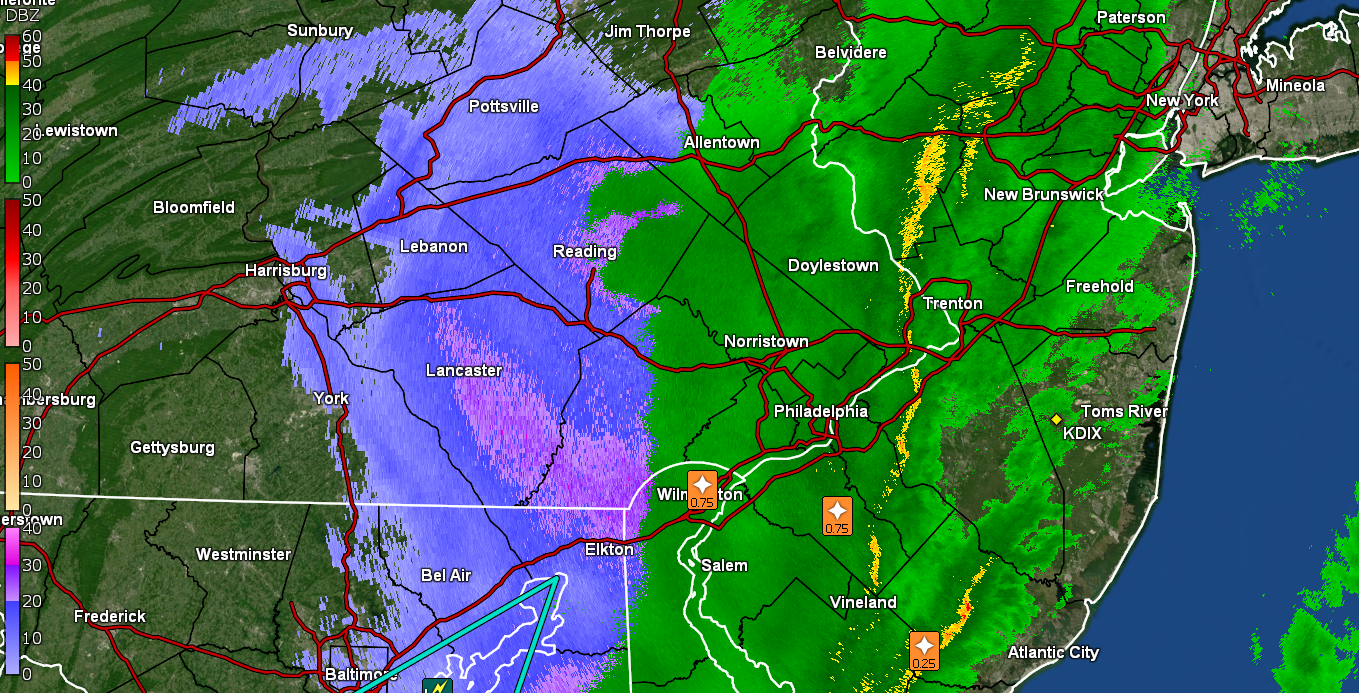
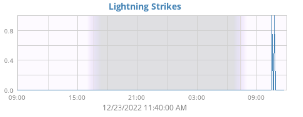
My lightning detector picked up both strikes although only the first was audible with an extended thunder clap. Am now down to 38 with dp 37 and 0.86" in the bucket. May try to bring in my Stratus to do a measurement before it freezes solid and maybe take out the inner tube and just leave the big tube out.
-
Currently very breezy here and temp down to 39 with dp 38 with light rain. Am up to 0.85" rain for the day. When I popped out briefly, am not seeing any frozen yet.
-
Temp dropping. Down to 41 now (dp 40) and another convective strike nearby about 7 minutes ago (didn't hear any thunder with it). Have light rain now and up to 0.79" for the day.
-
Pouring and just had some lightning/thunder about 10:26 am. Getting 0.43"/hr rate (ETA now at 0.54"/hr) and am up to 0.75". Temp 44 with dp 44.
-
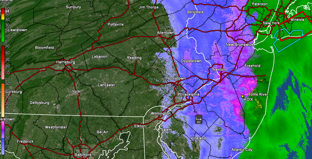
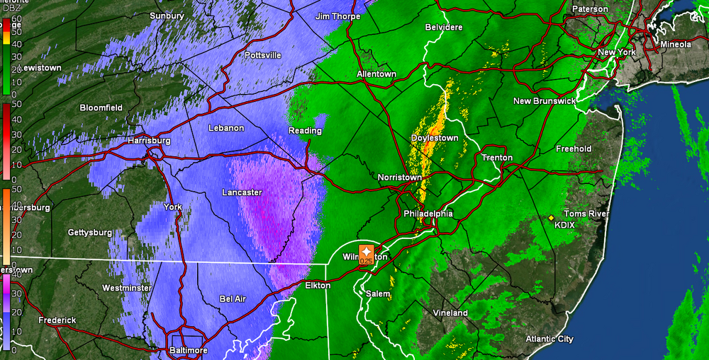
That WWA Newman posted for N/W, also got lofted all the way to about the first set of counties into NJ and down into parts of DE and MD. Winter Weather Advisory URGENT - WINTER WEATHER MESSAGE National Weather Service Mount Holly NJ 909 AM EST Fri Dec 23 2022 DEZ001>003-MDZ012-015-019-020-NJZ009-010-012-015>019-021-PAZ070- 071-104-106-240315- /O.NEW.KPHI.WW.Y.0020.221223T1409Z-221223T2300Z/ /O.CON.KPHI.WC.Y.0003.221223T2300Z-221224T1500Z/ New Castle-Kent-Inland Sussex-Kent MD-Queen Annes-Talbot-Caroline- Hunterdon-Somerset-Middlesex-Mercer-Salem-Gloucester-Camden- Northwestern Burlington-Cumberland-Delaware-Philadelphia- Eastern Montgomery-Lower Bucks- Including the cities of Wilmington, Dover, Georgetown, Chestertown, Centreville, Easton, Denton, Flemington, Somerville, New Brunswick, Trenton, Pennsville, Glassboro, Camden, Cherry Hill, Moorestown, Mount Holly, Millville, Media, Philadelphia, Norristown, Lansdale, Morrisville, and Doylestown 909 AM EST Fri Dec 23 2022 ...WINTER WEATHER ADVISORY IN EFFECT UNTIL 6 PM EST THIS EVENING... ...WIND CHILL ADVISORY REMAINS IN EFFECT FROM 6 PM THIS EVENING TO 10 AM EST SATURDAY... * WHAT...For the Winter Weather Advisory, a strong cold front moving west to east across the area this morning will bring rain showers changing to a quick burst of snow with rapidly dropping temperatures. Snow accumulation will be limited to a light coating up to a half inch but it will fall in a brief period leading to a quick drop in visibility and icy conditions. Winds gusting as high as 50 mph along and behind the cold front. For the Wind Chill Advisory, very cold wind chills expected. Wind chills as low as 15 below zero. * WHERE...Portions of central, northern and southern Delaware, northeast Maryland, central, northern, northwest and southern New Jersey and southeast Pennsylvania. * WHEN...For the Winter Weather Advisory, until 6 PM EST this evening. For the Wind Chill Advisory, from 6 PM this evening to 10 AM EST Saturday. * IMPACTS...Plan on slippery road conditions. The hazardous conditions could impact the evening commute. Gusty winds could bring down tree branches and result in power outages. The cold wind chills could result in hypothermia if precautions are not taken. * ADDITIONAL DETAILS...The snow will be brief but icy conditions may linger through at least this afternoon. PRECAUTIONARY/PREPAREDNESS ACTIONS... Slow down and use caution while traveling. Use caution while traveling outside. Wear appropriate clothing, a hat, and gloves. The latest road conditions for the state you are calling from can be obtained by calling 5 1 1. && $$
-
SAT word for the day!
-
I wanted to text my sis to tell her that it was "blizzarding" out there but I know there's a "technical" definition for what would be considered "a blizzard". Still getting on and off rain and am up to 0.52" with more apparently incoming. Temp is 44 with dp 44 and light rain.
-
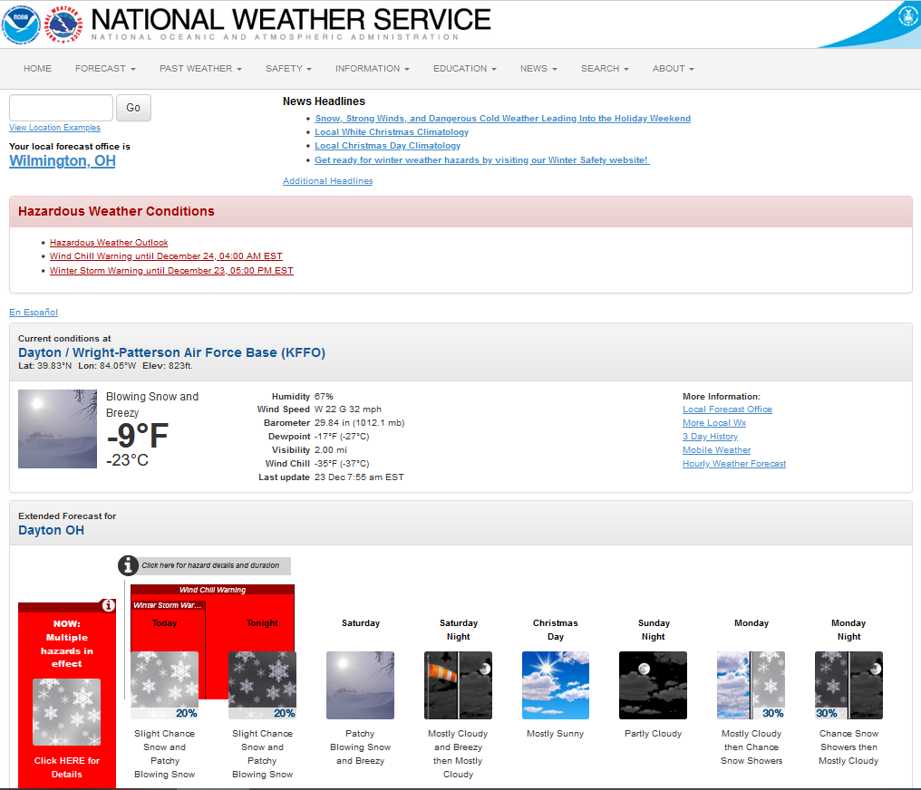
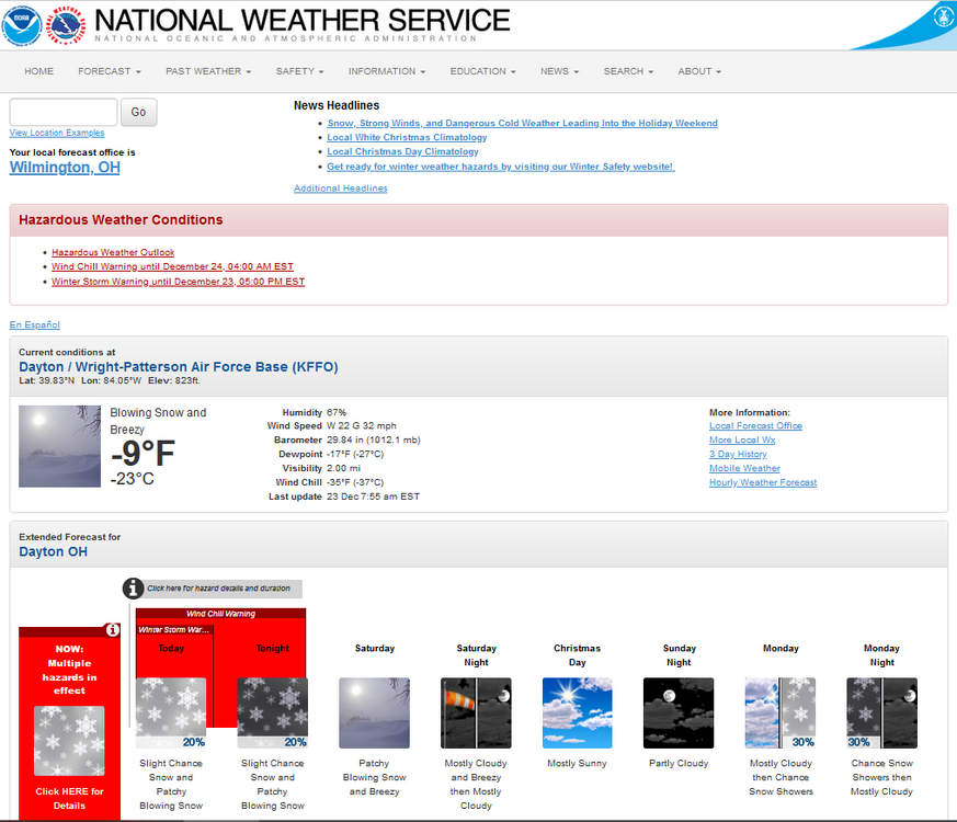
One of my BIL's is from Dayton, OH and some years he and my sis would drive out there for Christmas (they were there at Thanksgiving this year) and I just checked and it's -9! Many of the times they did go out there this time of year, they always ended up getting caught in some kind of snow/frozen either while there or on the way there this time of year. Currently 44 with dp 44 and some light rain has started up again here, with 0.50" in the bucket sofar.
-
My high for today likely will be the 57 at 2:40 am this morning and I finished up with 1.01" of rain yesterday with 0.48" this morning for a 2-day, 1.49" event total Currently overcast, breezy, and 47 with dp 46.
-
I blame RedSky for making me watch his chasers in FL & SC chasing Hurricane Ian. Looks like the coastal is pushing some heavier blobs up from the south. Am currently at 46 with dp 45 and very light rain with 0.68" for the event so far. The wind gusts continue to increase as well.
-
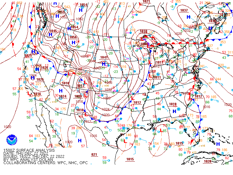
Mt. Holly tweeted a graphic model prediction of the temp drop to happen tomorrow (e.g., going from 42 to 15 in 12 hours) - Lots of hazard watches, advisories, warnings up now (including a Wind Chill Advisory & a Wind Advisory for much of the CWA) - Wind Chill Advisory URGENT - WINTER WEATHER MESSAGE National Weather Service Mount Holly NJ 258 PM EST Thu Dec 22 2022 DEZ001>004-MDZ012-015-019-020-NJZ009-010-012>027-PAZ070-071- 101>106-230900- /O.NEW.KPHI.WC.Y.0003.221223T2300Z-221224T1500Z/ New Castle-Kent-Inland Sussex-Delaware Beaches-Kent MD- Queen Annes-Talbot-Caroline-Hunterdon-Somerset-Middlesex- Western Monmouth-Eastern Monmouth-Mercer-Salem-Gloucester-Camden- Northwestern Burlington-Ocean-Cumberland-Atlantic-Cape May- Atlantic Coastal Cape May-Coastal Atlantic-Coastal Ocean- Southeastern Burlington-Delaware-Philadelphia-Western Chester- Eastern Chester-Western Montgomery-Eastern Montgomery-Upper Bucks- Lower Bucks- Including the cities of Wilmington, Dover, Georgetown, Rehoboth Beach, Chestertown, Centreville, Easton, Denton, Flemington, Somerville, New Brunswick, Freehold, Sandy Hook, Trenton, Pennsville, Glassboro, Camden, Cherry Hill, Moorestown, Mount Holly, Jackson, Millville, Hammonton, Cape May Court House, Ocean City, Atlantic City, Long Beach Island, Wharton State Forest, Media, Philadelphia, Honey Brook, Oxford, West Chester, Kennett Square, Collegeville, Pottstown, Norristown, Lansdale, Chalfont, Perkasie, Morrisville, and Doylestown 258 PM EST Thu Dec 22 2022 ...WIND CHILL ADVISORY IN EFFECT FROM 6 PM FRIDAY TO 10 AM EST SATURDAY... * WHAT...Very cold wind chills expected. Wind chills as low as 10 below zero. * WHERE...Portions of central, northern and southern Delaware, northeast Maryland, central, northern, northwest and southern New Jersey and southeast Pennsylvania. * WHEN...From 6 PM Friday to 10 AM EST Saturday. * IMPACTS...The cold wind chills could result in hypothermia if precautions are not taken. * ADDITIONAL DETAILS...A strong cold front will move through Friday bringing a very sharp drop in temperatures with strong southerly winds shifting to strong westerly. By Friday evening, this combination of wind and cold will result in wind chills dropping below zero with wind chills as low as 10 below expected overnight Friday night into early Saturday. PRECAUTIONARY/PREPAREDNESS ACTIONS... Use caution while traveling outside. Wear appropriate clothing, a hat, and gloves. && $$ Fitzsimmons Wind Advisory URGENT - WEATHER MESSAGE National Weather Service Mount Holly NJ 256 PM EST Thu Dec 22 2022 DEZ001>003-MDZ012-015-019-020-NJZ001-007>010-012-015>019-021- PAZ054-055-060>062-070-071-101>106-231000- /O.EXB.KPHI.WI.Y.0014.221223T1100Z-221224T0000Z/ New Castle-Kent-Inland Sussex-Kent MD-Queen Annes-Talbot-Caroline- Sussex-Warren-Morris-Hunterdon-Somerset-Middlesex-Mercer-Salem- Gloucester-Camden-Northwestern Burlington-Cumberland-Carbon- Monroe-Berks-Lehigh-Northampton-Delaware-Philadelphia- Western Chester-Eastern Chester-Western Montgomery- Eastern Montgomery-Upper Bucks-Lower Bucks- Including the cities of Wilmington, Dover, Georgetown, Chestertown, Centreville, Easton, Denton, Newton, Washington, Morristown, Flemington, Somerville, New Brunswick, Trenton, Pennsville, Glassboro, Camden, Cherry Hill, Moorestown, Mount Holly, Millville, Jim Thorpe, Stroudsburg, Reading, Allentown, Bethlehem, Media, Philadelphia, Honey Brook, Oxford, West Chester, Kennett Square, Collegeville, Pottstown, Norristown, Lansdale, Chalfont, Perkasie, Morrisville, and Doylestown 256 PM EST Thu Dec 22 2022 ...WIND ADVISORY IN EFFECT FROM 6 AM TO 7 PM EST FRIDAY... * WHAT...Southwest winds 20 to 30 mph with gusts up to 50 mph expected. * WHERE...Portions of central, northern and southern Delaware, northeast Maryland, central, northern, northwest and southern New Jersey and east central, northeast and southeast Pennsylvania. * WHEN...From 6 AM to 7 PM EST Friday. * IMPACTS...Gusty winds could blow around unsecured objects. Tree limbs could be blown down and a few power outages may result. * ADDITIONAL DETAILS...A brief period of wind gusts near 60 mph is possible as a strong cold front races through the area from late morning to early afternoon Friday. PRECAUTIONARY/PREPAREDNESS ACTIONS... Use extra caution when driving, especially if operating a high profile vehicle. Secure outdoor objects. && $$ Philly's public schools will be all-virtual tomorrow due to the forecast. Currently light rain and 45 here with dp 45 and 0.42" of rain.
-
That probably would work in an ENSO neutral/El Nino scenario in another month or so. The front is moving too fast to have had us have enough of a sustained antecedent cold though. And even with that, this scenario has that MW cutter low bombing out and taking all the thunder out of all the other little lows. Temp still rising and I'm now up to 42 with dp 42 and 0.38" in the bucket.
-
Temp still rising here IMBY and at 39 with dp 39. Have 0.21" in the bucket so far and currently have light rain. Am getting rain up against my back windows that face NE and checked to see the low getting ready to emerge off the coast. So between that and the highs up over Maine and NE Canada, am getting that easterly component.
-
Rain is steadier and temp continues to rise and is at 37 with dp 36. Have 0.09" so far and the winds have also picked up. We are also in a New Moon phase so this would exacerbate any coastal flooding (although not as much as would have occurred from a Full Moon).
-
Finally tipped the bucket for 0.01". Since there is a flood watch up for the area, much more to come today and tomorrow. Still 36/dp 34.