Volcanic Winter
-
Posts
1,674 -
Joined
-
Last visited
Content Type
Profiles
Blogs
Forums
American Weather
Media Demo
Store
Gallery
Everything posted by Volcanic Winter
-
Got down to 51 this morning, impressive.
-
 Laughing, thank you!
 -
Swamp ass. I even shave my ass to help combat the never ending battle with swamp ass in NJ CFa subtropical summers. I vastly prefer the dry, frozen tundra-ass one gets in a proper winter over the wet, humid subtropical marshland of summer.
-
Lived in North Brunswick at the time. Irene was kind of a shitshow. Rode the storm out at my sister’s house in northern Toms River with my parents, and I remember it taking hours to get home back to NB with my girlfriend (now wife).
-
Just got stung by a wasp . Little menace must’ve landed on my back while I took the trash out. Came inside, at least a couple mins later I felt something crawling on my back. Reached to it instinctually and immediately felt the sharp sting right through my shirt, and then it somehow stung my hand between my fingers too before falling on the floor… Good sized wasp, red and yellow, super ugly. Never been stung by one before and I have a huge welt, back feels like it’s on fire. Can’t lay down. Meh/10 do not recommend.
-
Yup, living near the beach is beautiful. My parents live in Seaside Park. Bought a house in the 70’s here for like 70k at the time. They’re from Middlesex but then moved to Monmouth when they had me, and I got to grow up spending my summers in SSP surfing and whatnot. They were very lucky in Sandy!
-
Where are you from originally man?
-
I’m SO hyped to be in here with you guys late fall and winter again. Even when it’s a shitshow (especially when?), this place is always amusing. And genuinely AmericanWX has one of the smartest groups of individuals I’ve ever interacted with online. Let’s get that snow this year, but hey at least the company ain’t bad either.
-
El Nino 2023-2024
Volcanic Winter replied to George001's topic in Weather Forecasting and Discussion
So I think it’s extremely fascinating, but not something I’m intimately familiar with. I’m playing catch up to all of you regarding teleconnection meteorology. I still need to look into what we discussed and the paper you sent me, but it’s definitely intriguing to me. You know, I’m so used to looking into the large events that it’s easy to pass up clusters of smaller events, and 2008-2009 had a significant cluster of VEI 4 eruptions between .1 - 1 cubic kilometers (Okmok, Chaiten, Kasatochi, and Sarychev Peak, with Eyllafjallajökull occurring in 2010 which was a very ash rich but relatively small VEI 4). Honestly 2008-2011 was a very active period volcanically, including 2011’s Puyehue Cordon Calle eruption (my forum avatar, GORGEOUS eruption) which is commonly referenced as a baseline VEI 5 but IMO is better categorized as a high end VEI 4, but that is semantic as the difference between .9 cubic kilometers and 1 is negligible. I’m going to look further into this, thanks for mentioning. Edit: One area of interest to me for clues is the Little Ice Age. It is commonly referenced that volcanism played a large role in driving this period (along with the Maunder Minimum, perhaps agricultural factors I’ve read, etc), but we know that typically even very large eruptions only impact the climate for several years. Certainly not decades to centuries. While it’s true there were many VEI6 and large 5’s throughout this period, along with Tambora’s VEI 7 (and the Samalas VEI 7 in the 13th century which was basically one island over from Tambora, interestingly), this really wasn’t anything too unusual. Every thousand years will see 2-3 VEI 7 or borderline 7’s, on average. You’ll get something like 2-4 VEI 6’s or borderline 6’s per century. The LIA had big volcanism, but there’s always big volcanism lurking just outside the timespan of a human life. There had to be self reinforcing positively interfering mechanisms at play throughout this period, possibly a cooling of the North Atlantic along with long stretches of -NAO/AO cooling North America and Europe? While glaciers advanced in many locations throughout the LIA, I still understand it to be a regional phenomenon. Just a thought that came to mind based on your comment. Volcanism plays an enormous role in the ebb and flow between hothouse and stadial climate states as well, with ‘flood basalts’ being one of the main drivers of paleoclimate hothouses. But these eruptions are on a scale that is unfathomable over long periods of time (100,000+ cubic kilometers over thousands of years), and occur with many 10’s of millions of years between. They’re also more common when the continents are in a conjoined state as it helps build the pressure needed to contain a mantle plume and allow an eruption that size to occur. I digress , the point is simply that volcanism and earth’s climate are highly linked throughout time. And I think it’s certainly possible there’s small scale stuff happening (ie teleconnection forcing) like what you’re touching on. -
El Nino 2023-2024
Volcanic Winter replied to George001's topic in Weather Forecasting and Discussion
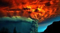
Apologies for getting to this rather late in the discussion, was going to answer in the morning but I'm having some trouble sleeping anyway. Lengthy volcano nerd post incoming, feel free to skip this post to get back to ENSO discussion . To be honest, regarding Hunga Tonga you all are better equipped to debate its impacts than I am at this point, as it is very much not the classic 'Pinatubo style' atmospheric SO2 bomb sort of eruption that imparts a well studied downward forcing of surface temps via overloading of the stratospheric aerosol veil with sulphate. The principal driver of HTHH's impact as we know is water vapor, and that is very much an anomaly among large explosive events. While most volcanoes have a water component to the magma (it acts as a volatile), in a typical large explosive event the water vapor component is well overshadowed by SO2 and fine ash particulates. You guys know way more ocean-atmospheric physics than I do with regard to considering the water vapor impact (which will last longer than the typical SO2->sulphate production in the stratosphere; the chart @40/70 Benchmark linked shows the timeline nicely and is from a source I'm familiar with). Couple things. Take a look at this video: https://assets.researchsquare.com/files/rs-2044907/v1/153086f25b0f0b7d7068563b.mov That monster column is apparently only a total volume of 1.7 cubic kilometers, while underwater PDC (pyroclastic density currents) / ignimbrite deposits totaled over 10 cubic kilometers. If this is accurate, this was a true Pinatubo sized blast and the first VEI 6 since that eruption. However, the vast majority of the gas and particulate matter went into the ocean and not the atmosphere. That monster column? Mostly boiled seawater... 1.7 cubic kilometers would be a small VEI 5 and not typically the sort that would have a measurable climate impact, and that checks out with the measured atmospheric SO2 pulse from the eruption (which was well below even El Chichon in the 1980's). Pinatubo was over 10 cubic kilometers all blasted straight up. Source for the above: https://assets.researchsquare.com/files/rs-3000198/v1/95ad0f06-876f-487c-ba2b-fed11310ce6a.pdf?c=1686242395 -- I believe you guys were discussing if HTHH's plume would've crossed hemispheres and frankly it's a good question and the answer varies from eruption to eruption. Ice cores between Greenland and Antarctica often show different levels for the same eruption depending on where the eruption took place and what the atmospheric conditions were like at the time of the eruption, which matter as far as dispersal of the aerosols. Generally big eruptions do cross hemispheres, but it really varies significantly and usually the hemisphere the eruption occurred in receives more of the particulate load. If we're talking only 1.7 cubic kilometers (which is only slightly larger than Mt St Helens 1980) of atmospheric ejecta, it really is irrelevant because it's not large enough to matter. It all goes back to the water vapor, as that is a separate measurement and would be the reason the eruption plume in the above video is so monstrous. One thing is for certain, I would not want to have been a fish near HTHH when it detonated. 10 cubic kilometers of PDC deposits erupted in just a couple hours is a massive and extremely intense event. It just beat the hell out of the seafloor more than the atmosphere. Seriously, just because most of it went into the ocean, this was still a once in a thousand year caldera-forming eruption from HTHH and is easily one of the most intense eruptions witnessed by man, though Krakatau and Novarupta were 3x larger, and Tambora was as much as 15x larger. But yeah, go back to the water vapor. I read something like 1/10th of the total that normally resides up there was ejected in the eruption, and that it could remain for up to 5-10 years? That's definitely what I would focus on, because that's the 'story' of the HTHH eruption. -
Is this what you rock in the middle of winter?
-
56 this AM for me down in the pines. Pretty amazing.
-
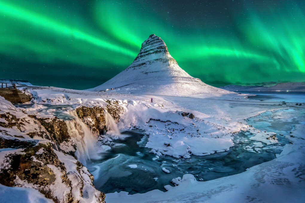
At the border of Manchester and Toms River I’ve dodged so much of these central / south events. Any of the previous watches and elevated severe days recently we’ve basically had nothing but drizzles, haven’t seen much in the way of thunder this summer actually. Temp sitting at 73.9 for the month of August to this point, vs 77.2 for the month of July and 67.1 for June. Interesting summer so far! Really starting to feel that fall / winter hype, my time to shine! Nov through Feb are my favorite months of the year. Wife and I working out if we’re doing our hiking trip to Iceland this Nov again. The eruption of Fagradalsfjall is over now but would be fun to get out to the fresh lava flow field. Good things to look forward to.
-
They expanded the 2% tornado risk area to cover the whole arc of the coast from NC to MA.
-
Yeah, I had little more than a cool looking shelf cloud pass overheard with a couple distant rumbles and some rain. Maybe one moderate wind gust. Wasn’t really even a strong thunderstorm at that point, let alone severe. I’m about 15 miles inland from the shore.
-
This is also why I personally enjoyed 2014 so much; I didn’t get too many big storms that year but we had very frequent minor snowfalls that stuck around for weeks. I distinctly remember my front porch being iced over and frequently replenished with powder for weeks on end that winter; for me that’s the holy grail even beyond gigantic coastals.
-
Exactly the post I was about to make. Sure, we may get more juiced up storms before temperature becomes completely prohibitive, but in the interim winters have warmed enough that we’re starting to lose borderline events that would’ve been paste-jobs in earlier decades. This issue has often been covered up by the monstrous MECS & HECS we’ve been getting in recent years. @bluewavehas posted about this frequently with good data to back up how we’ve begun a ‘feast or famine’ regime where we’ve lost many of our small to moderate events that’s covered up with monstrous storms. Of course the foot+ storms are amazing to witness and are very fun, but it’s those small to moderate events along with cold enough air temperatures to keep it around a few days that really provides a winter feel. And this is something we’ve really been lacking lately.
-
Can’t recall an SPC moderate risk this far east before, I’m assuming though this definitely isn’t a first, right? Still that 10% tornado risk area and CAPE estimations in the DC area are pretty wild. Here at work in Hillside (due west of NYC) it’s been consistently cloudy with on and off light rain, humid but not especially warm. Unless the sun starts peaking out I’d imagine it keeps a lid on severe potential up here.
-
My bar is “better than last winter.” I think that’s reasonable, right? Tell me that’s reasonable, dammit.
-
I know last summer was hot here, but it seems the past few years we’ve avoided the truly record breaking, insane heat yes? Thinking back to the June 2021 Pac NW heat dome as well. I know we had multiple 100 days last summer, but I don’t recall a truly sustained ‘giga heatwave’ around here recently, just our usual ‘NYC Metro Swampass Special.’ Is that more because dews cap the top end heat, or have we not had the sustained high heights pattern that would build a traditional heat dome here yet? I’m sure our time is coming if it’s the latter.
-
Wow, got down to 54.3 for a low!
-
Cool! Where you goin man?
-
Having a good camera and learning how to shoot with it is such a relaxing and rewarding hobby. Enjoy Liberty. Go to Iceland and get some aurora shots! I’ll give you all the tips.
-
Yeah. This is why I’ve refrained from talking about ‘impacts’ of the AMOC switching to its other stable configuration. We know the Younger Dryas AMOC slowdown returned the planet to a colder state, but that it may have been regional (which is not surprising). We’re in a different climate state now with different starting parameters, and I’m not educated enough on the subject to speculate on the effect of a complete AMOC slowdown in the modern era. I know this is somewhat contentious, though. With that said, I would be very surprised if it did not cause a multi-century shift in climate norms across several regions, along with unexpected changes in others.
-
This is sort of unrelated directly, but tangentially related to what you’re talking about. I follow a well published university astrophysicist that writes for and helps run a geology blog; a very knowledgeable, multi-disciplinary dude with a lot of interesting perspectives. He believes based on comparing the duration of our current interstadial(length of the Holocene) with past interstadial in the recent Quaternary, along with the direction we’re heading along the Milankovitch cycles that help govern glaciation, that the LIA was potentially the beginning of the slide toward the next proper stadial (glacial, Pleistocene like climate). And that human activity effectively aborted it with carbon heat energy, which is the same mechanism that has pulled the earth out of ice ages throughout the epochs. In a way, our activity had an even bigger impact than we realize. Take this with a huge grain of salt, it’s a speculative opinion from a smart dude and nothing more. But it’s interesting food for thought. And regarding the ‘ice age’ fears during the 70’s, well climate science simply improved dramatically over time. And that era was when sulfur and other aerosols were still exerting considerable influence in suppressing the impact of rising CO2 (not unlike sustained volcanic influence), so it’s not wholly surprising to see a couple decade downturn with that in mind. Climate science only improves as we move forward and learn more about the various feedback mechanisms built into our planet. It’s also clearly established how CO2 has been correlated to every natural climate excursion, both warm and cold, going back throughout the Quaternary. There are many natural processes that help raise and lower CO2 over the millennia, but what we’re doing is causing CO2 to skyrocket at an unprecedented rate. The people that deny human caused climate change by talking about natural earth cycles are ‘half right,’ in a sense, while missing extremely important context with respect to what that actually means and how that relates to the Anthropocene.


