TheClimateChanger
-
Posts
4,436 -
Joined
-
Last visited
Content Type
Profiles
Blogs
Forums
American Weather
Media Demo
Store
Gallery
Everything posted by TheClimateChanger
-
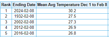
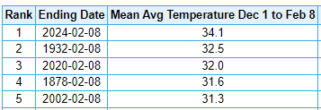
Well, 1877-78 was always considered to be the warmest of record by far, including the pioneer era records at Fort Snelling dating back to 1820. So when there's more than 200 years of data, and it's beating the record by nearly 3F, I think 1 in 1000 is a reasonable estimate for a recurrence interval, no?
-
Winter 2023/24 Medium/Long Range Discussion
TheClimateChanger replied to Chicago Storm's topic in Lakes/Ohio Valley
All this wintertime warmth at Dayton, and watch, you are probably going to be 89'd all summer long.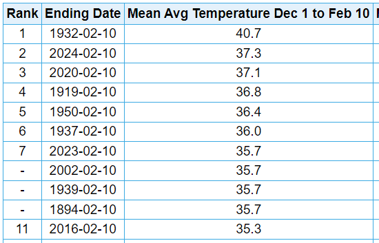
-
Central PA Winter 23/24
TheClimateChanger replied to Voyager's topic in Upstate New York/Pennsylvania
Would be funny if Harrisburg picked up a foot and had more snow than Erie on the season midway through February. -
Pittsburgh, Pa Winter 2023-24 Thread.
TheClimateChanger replied to meatwad's topic in Upstate New York/Pennsylvania
Brutal. At least the 3K still gives us a couple of inches. -
Let’s talk winter!! Ohio and surrounding states!!
TheClimateChanger replied to Steve's topic in Lakes/Ohio Valley
Hmm, I'm taking the under here. -
Pittsburgh, Pa Winter 2023-24 Thread.
TheClimateChanger replied to meatwad's topic in Upstate New York/Pennsylvania
Well, I always get pushback when I use mean temperatures and the response is always high temperatures are more important. Applying that logic fairly, it was easily the warmest first 10 days of February: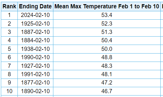
-
Pittsburgh, Pa Winter 2023-24 Thread.
TheClimateChanger replied to meatwad's topic in Upstate New York/Pennsylvania
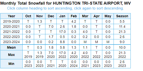
Yes, this is what I was getting at it. Dayton only has 5 periods with two day totals of a foot or more dating back to the 19th century (ignoring the double counting of the 1978 blizzard). -
Pittsburgh, Pa Winter 2023-24 Thread.
TheClimateChanger replied to meatwad's topic in Upstate New York/Pennsylvania
18z GEFS is at a mean of 6.3” for the city, albeit assuming 10-1 ratio (which is probably too high). -
Pittsburgh, Pa Winter 2023-24 Thread.
TheClimateChanger replied to meatwad's topic in Upstate New York/Pennsylvania
This is true. When I noted we haven’t had a 12” calendar day since 1994, I was playing around on xMacis with other locations, and Dayton has only ever had one day with 12” or more (and only barely) in 1978. I think warning criteria might be 4” there, but they are even worse for big storm climatology. Same deal with Columbus where I think warning criteria is the same as Pittsburgh. -
Pittsburgh, Pa Winter 2023-24 Thread.
TheClimateChanger replied to meatwad's topic in Upstate New York/Pennsylvania
Looks like we’ve lost the HRRR. Too far south and east for most of us to get more than a couple of inches, using actual model ratios. -
Pittsburgh, Pa Winter 2023-24 Thread.
TheClimateChanger replied to meatwad's topic in Upstate New York/Pennsylvania
-
Pittsburgh, Pa Winter 2023-24 Thread.
TheClimateChanger replied to meatwad's topic in Upstate New York/Pennsylvania
Is thundersnow possible with this system? -
Pittsburgh, Pa Winter 2023-24 Thread.
TheClimateChanger replied to meatwad's topic in Upstate New York/Pennsylvania
Impressive, and this 8.3” is with actual modeled ratios. This looks like it could be a big one. -
Pittsburgh, Pa Winter 2023-24 Thread.
TheClimateChanger replied to meatwad's topic in Upstate New York/Pennsylvania
Wouldn’t worry too much about the global models at this time frame. Lower resolution makes it harder to model this type of a dynamic system with marginal thermals. -
Pittsburgh, Pa Winter 2023-24 Thread.
TheClimateChanger replied to meatwad's topic in Upstate New York/Pennsylvania
-
Pittsburgh, Pa Winter 2023-24 Thread.
TheClimateChanger replied to meatwad's topic in Upstate New York/Pennsylvania
Looks pretty solid to me, especially with 10:1 ratios. -
Pittsburgh, Pa Winter 2023-24 Thread.
TheClimateChanger replied to meatwad's topic in Upstate New York/Pennsylvania
Looks like a classic late spring snowstorm. Sort of reminiscent of that March 20-21, 2018 event, which brought up to 10.5” at the airport if I recall correctly. I think we were looking at 2-4” heading into that event. Only question is how far north this event tracks. Looks like somebody will have a nice accumulation. As is the case with spring snows, shouldn’t last too long as temperatures should be above freezing most days. -
Crazy stuff. This must be a 1 in 1000-year winter heat wave up there, but barely registering with our derelict media these days. Minneapolis Green Bay Milwaukee
-
Winter '23-'24 Piss and Moan/Banter Thread
TheClimateChanger replied to IWXwx's topic in Lakes/Ohio Valley
Blowing snow every chance you get and being situated on a north facing slope? Plus, many recent overnights have been below freezing, potentially allowing some or all of the snow melting during the day to be replaced. Humidity levels have also been low, which would limit melting. Boston Mills has a 36" base, despite 6" of snow on the season. -
Winter '23-'24 Piss and Moan/Banter Thread
TheClimateChanger replied to IWXwx's topic in Lakes/Ohio Valley
With numbers like these, Ohio might as well be the new Tennessee. Just across the river...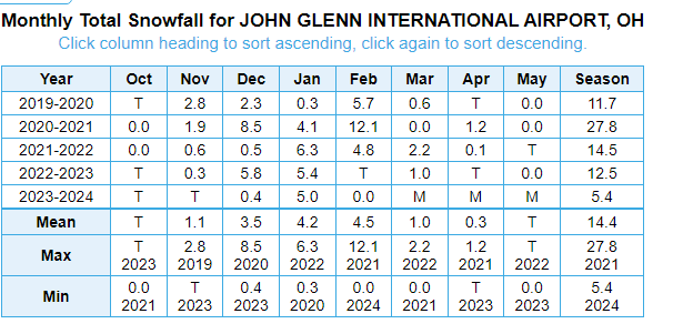
-
Don’t forget to share the bad news too.
-
Funny how it used to always be the Kuchera maps that were the clown maps, and now it's the 10:1 ratio maps.
-
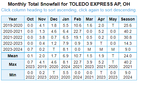
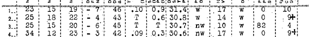
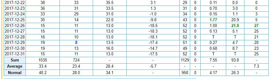
In addition to xMacis missing several days of snowfall from that winter, including the 6.6" snowstorm on January 1st, there are several periods of observations that are physically impossible. Snow depth increases by 3.0" from 1-14 to 1-16, on 2.7" of new snowfall. Snowfall increases from 19.9" at 7 pm on 1/30 to 22.7" at 7 pm on 1/31 - an increase of 2.8" with a two-day total snowfall of 2.3". Meaning even if all of the snow on the 30th fell after 7 pm, depth increased by at least a half inch more than reported snowfall. And, of course, depth proceeds to increase by nearly nine inches between 1/31 and 2/1, with only another 0.9" of snow reported. As noted, the 4 days of 30"+ snow depth are more than all other years combined in the threaded record. Even in December 2017, when nearly 100" is alleged to have fallen, depth never exceeded 27". Look, nearly 43" over two days with a peak depth of 27". Compare that to these meticulous, uninflated numbers from 1944-45.


-
Pittsburgh, Pa Winter 2023-24 Thread.
TheClimateChanger replied to meatwad's topic in Upstate New York/Pennsylvania
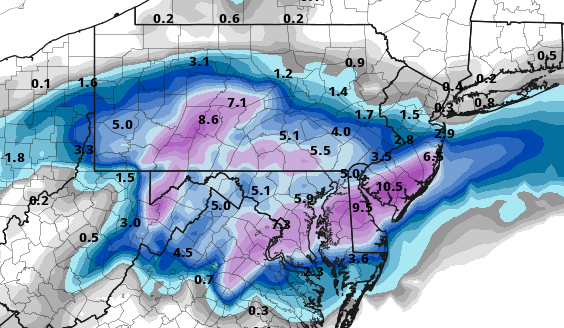
Sharing a post from @mitchnickin the Central PA forum showing the GEFS (see link above). Looks like a miss or minor event on the majority of ensemble members (although there are a couple/few big hits). -
Pittsburgh, Pa Winter 2023-24 Thread.
TheClimateChanger replied to meatwad's topic in Upstate New York/Pennsylvania
I will say the 24-hour period from 12z 12/13 to 12z 12/14 looks solid. 5.0" using Kuchera ratios, and 7.3" at 10:1 [probably too high with marginal temps], and this is only 5 days out [rather than some distant, remote possibility]. But other than that, not too many big threats.