
SolidIcewx
-
Posts
1,647 -
Joined
-
Last visited
Content Type
Profiles
Blogs
Forums
American Weather
Media Demo
Store
Gallery
Everything posted by SolidIcewx
-
@Chinook possible tornado damage in Fraser MI
-
Mesoscale Discussion 1349 NWS Storm Prediction Center Norman OK 0238 PM CDT Wed Jun 18 2025 Areas affected...northern IN...southern Lower MI...northwest OH Concerning...Tornado Watch 434... Valid 181938Z - 182145Z The severe weather threat for Tornado Watch 434 continues. SUMMARY...Northern, fast-moving portion of a QLCS should progress across the rest of northern Indiana into southern Lower Michigan and northwest Ohio through early evening. Damaging winds should be the main threat, but a tornado or two will be possible. Downstream watch issuance expected by 21Z. DISCUSSION...The northern portion of a QLCS has been steadily progressing east around 45 kts with a history of estimated to measured gusts of 55-70 mph. This fast-moving portion of the line has likely outpaced stronger low-level shear across southwest IN, per comparison of VWX and IWX VWP data. Given largely veered surface winds downstream and recent HRRR guidance, an outflow-dominated line will likely persist as it spreads into southern Lower MI and northwest OH through early evening. Damaging winds should remain the primary hazard, with a tornado or two possible in any QLCS mesovortices across northern IN.
-
Just some wind is all I heard from the Utility end of things. Run of the mill radar indicated storm.
-
I seen that had to call a couple coworkers and tell them to get inside. (They never look at the weather really)
-
 Air does feel kinda tense today. Pure sun off rip as well
 -
Great peice!
-
That was my thought as well. But this one would have a bit more of a northerly component compared to those storms. Coworker of mine told me her story of surviving the Palm Sunday f4 just a few months ago.
-
Nebraska wedge was pretty insane from last night
-
4/2-4/3 Potential Major Severe WX Outbreak
SolidIcewx replied to Geoboy645's topic in Lakes/Ohio Valley
At least we will have hella boomers again -
4/2-4/3 Potential Major Severe WX Outbreak
SolidIcewx replied to Geoboy645's topic in Lakes/Ohio Valley
Im very curious to see how today plays out. Wonder if it will clear out a bit up my way. Had snow showers and sleet this morning. Some good rumbles of thunder and heavy rain. Let’s see what this evening brings -
If we had summer thermos I think I’d be safe to say we’d have a big problem on our hands.
-
Power flashing on and off in Canton
-
Im thinking the same thing. Kinda odd considering the MD that came out for the area
-
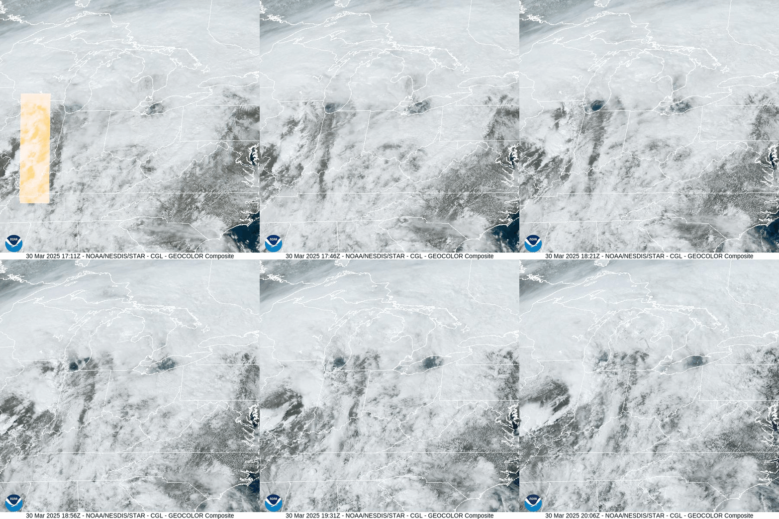
Starting to clear out in MI for sure
-
Mesoscale Discussion 0305 NWS Storm Prediction Center Norman OK 0249 PM CDT Sun Mar 30 2025 Areas affected...Southern Lower Michigan...Northwest Ohio Concerning...Severe potential...Tornado Watch likely Valid 301949Z - 302145Z Probability of Watch Issuance...95 percent SUMMARY...An organized line of storms with a history of 60-85 mph wind gusts will continue into western Ohio and southern Lower Michigan. Risk for damaging winds will continue with more isolated/uncertain threats for large hail and tornadoes. DISCUSSION...An organized line of fast-moving storms continues northeastward through central/northern Indiana. Modest destabilization continues ahead of this line into portions of western Ohio and southern Lower Michigan. Given the organization of this line, potential for severe/damaging gusts will remain even as buoyancy tends to wane north and east. This line of storms has a history of producing wind gusts of 60-85 mph. Damaging winds will likely remain the primary risk. Isolated large hail could occur, but storm mode will mitigate that risk. Likewise, storm mode is also not optimal for tornadoes. Regional VAD winds and RAP forecast soundings do suggest some QLCS tornado risk will exist, but this risk diminishes with eastward extent. One or more watches will need to be considered for portions of western Ohio and southern Lower Michigan by 21Z.
-
ENH now up into the thumb. Looking better for us as the day goes on. Just need some peeks of sunshine.
-
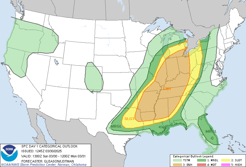
ENH now into southern/SE MI
-
Alright not gonna lie that public alert for weather in SEMI was a bit much considering it came in like a amber alert..
-
Coulda swore this was just a marginal yesterday?
-
WINTER STORM WARNING IN EFFECT FROM MIDNIGHT TONIGHT TO 4 PM EST SUNDAY... * WHAT...Heavy snow expected. Total snow accumulations between 5 and 7 inches. Winds gusting as high as 35 mph on Sunday, which may lead to blowing and drifting of snow. * WHERE...Monroe, Wayne, Macomb, St. Clair, Sanilac, and Huron County. Monroe and Wayne are included even though I think of lakeshore and the ones bordering Huron
-
Winter storm warning kicking in with 5-7 still. I’ll take it honestly
-
Yeah I’m wondering what the hell happened last night. Suprised at only the duster this morning
-
Let’s not forget about the awesome photogenic job the wind can do along with great snowfall.
-
DTX must be writing up quite the AFD
-
Bring on the borderline blizzard. I’ll gladly stand outside with my joint during the brunt of it.



