George001
-
Posts
6,887 -
Joined
-
Last visited
Content Type
Profiles
Blogs
Forums
American Weather
Media Demo
Store
Gallery
Everything posted by George001
-
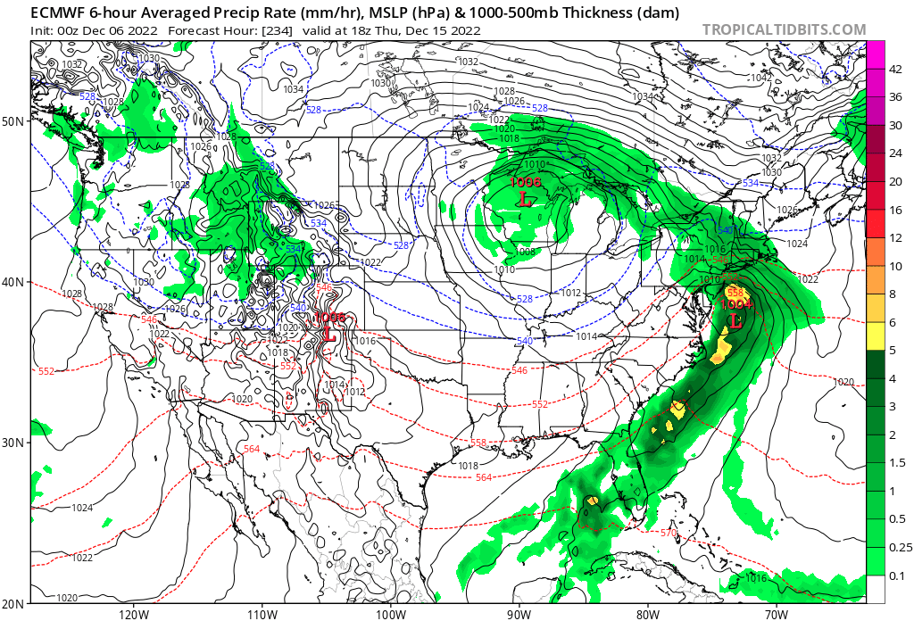
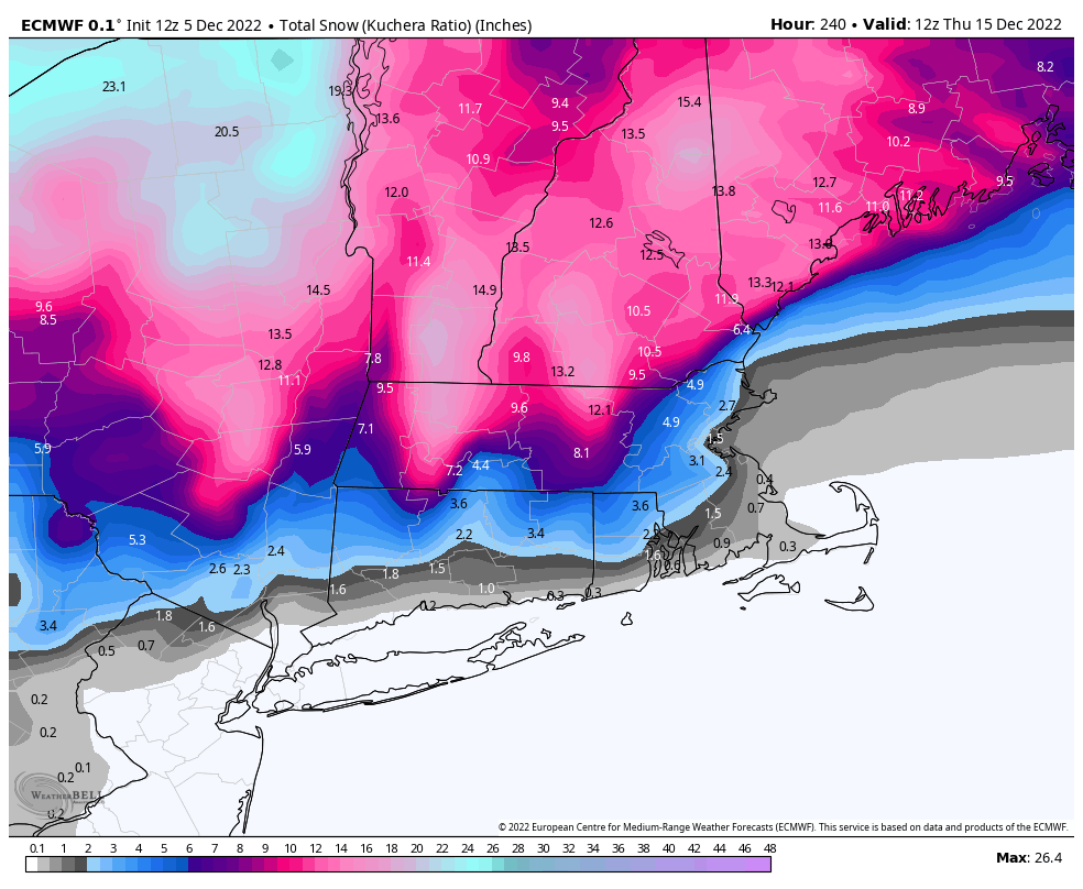
It did shift south some this run but still has a monster slow moving Miller B, it gives you over a foot now. It has been consistent and the EPS made a nod towards it earlier. OP Euro did too at H5, it looks like everything is trending towards the Canadian.
-
It’s more likely than the “upgraded” gfs being right. The EPS has a signal for that storm as well. Is there by any chance a way to access the old versions of the GFS? The GFS was half decent a few years ago but has been getting worse with every upgrade.
-
Yeah there is still plenty of time for that to change. The useful guidance trended in the wrong direction for that today, but like you said in earlier posts the guidance has not been handling the pacific well at all.
-
Yeah things have changed. I was wrong, I don’t know why it’s so warm on the models with the negative NAO and La Niña but it is. If all of them are showing it, it can’t really be ignored. That said it can still snow in a bad pattern. There is still very much a path to an epic December, get 1 storm to break right while the pattern is still unfavorable over the next 2-3 weeks, and then a big one when the epic pattern settles in. Honestly this development although frustrating right now actually increases the ceiling, as the duration of the epic pattern will take place closer to the heart of winter.
-
I’m not gonna ignore the Canadian. It is close enough to the event and has been much more consistent in showing something (not as extreme as today’s run obviously). In my opinion it is on to something, now I’m not expecting 15 inches of snow for my area and 2 feet+ inland, but a toned down version of that is very realistic.
-
I’ve noticed the entire evolution has slowed down. The 10th became the 12th and the 13th became the 15th. That’s a pretty big change. The 15th looks bad right now, but it’s still far enough away that there is time for it to change. The Canadian shows that the first threat shouldn’t be overlooked either, it has a slow moving Miller B for the 12th. The H5 pattern argues against a cutter, due to the strong -NAO. Just yesterday the models had a Miller B for the 2nd threat so I wouldn’t give up on that.
-
In Dec 2010 the pattern got delayed too. Delayed but not denied.
-
Euro is trying for a Miller B. If the primary low was in even Chicago instead on Wisconsin that would be a lot better for us. Still plenty of time to correct that. There was a storm in mid December a few years ago that gave Chicago a blizzard, but then it redeveloped offshore and turned into a Miller B. The secondary low underwent rapid cyclogenesis, and NYC north got buried. Both Chicago and Boston got over a foot of snow from that storm, and some areas in CNE/NNE got over 3 feet of snow.
-
The gfs got worse since the upgrade, it’s been shifting thousands of miles every run. The Euro has struggled with the pattern as well but not to that extent. Since when did blocks hook up with SE ridges? Aren’t they supposed to suppress the storm track south? If I end up being wrong and the blocking hooks up with the SE ridge, and then the low rams into the block I’ll admit it. But right now I am going to ignore the GFS and stick to looking at what the other models do. In my opinion every model is cutting the low too far inland, and I think it will turn into a Miller B as we get closer to the storm. There was a storm a couple years ago the models had cutting to Wisconsin, and then it turned into a Miller B in the mid range. That said, I do have concerns about the airmass. It is not all that cold.
-
Yeah I just looked at the 500 mb apparently the blocking weakens and expands south over the US. That’s strange, the other models don’t have it though. If that did happen I would think the storm would be suppressed if anything due to how far south the block is.
-
The gfs op hasn’t led the way with anything, it has been all over the place. Lows can’t ram into a massive block, the GFS is acting like the blocking doesn’t exist and keeps cutting the lows to Wisconsin, garbage model.
-
I would like to see the trough out west weaken though. It doesn’t need to be great but I would rather see a slightly negative PNA than a very negative one.
-
not bad

-
Euro is trying for a Miller B in that timeframe
-
The blocking is still there, the epic pattern just got delayed some. That doesn’t mean it won’t happen.
-
Easy just ignore the GFS because it sucks, it has a super nino pattern despite it being a moderate La Niña.
-
I’d lean towards the European guidance because it has been more consistent. The GFS is completely lost.
-
Storms cannot cut when there’s blocking this strong, the problem is the airmass sucks, and the ocean is still really warm. The earth is warmer than it used to be so more has to go right. Even a perfect track isn’t enough with the lack of cold, the low needed to deepen a lot and create its own cold air. Ridging doesn’t connect from the SE to Greenland, the block suppresses the SE ridge. NNE will still probably get lots of snow, but for the rest of us yeah the epic pattern looks like it’s going to be delayed. Honestly for those of us not in NNE the delay is good, because it means the window for the epic period is closer to peak climo when it comes. That said, the 13th threat hasn’t gone anywhere. The 10th is probably cooked though.
-
The surface looks odd, there are 3 lows. I would think they would combine into one big low. The location of the rain snow line is very reasonable though considering the airmass and ocean temps. Interior areas have a really good shot with this threat, those of us closer to the coast I think will have some ptype issues. Maybe something like March 2017 or the Feb storm a couple years ago where my area got 8 inches, and 20 min NW got a foot and a half.
-
Euro whiffs the first threat but the h5 looks great for the second threat.
-
I’m still keeping an eye on it but I like my chances for the 13th better. The airmass is better by then and the blocking is in a better position.
-
That’s a good point, climo is more hostile now than it is in early March especially for the coast. Even my area which isn’t right on the coast has done a lot better in March than December lately. December climo isn’t favorable to begin with but It feels like climate change has made it even less favorable. The warming oceans is a double edged sword, it can help storms bomb out and give crazy amounts of snow if the airmass is cold enough, but when the airmass is marginal it makes it a lot harder, even a bit of onshore winds and the coast is cooked.
-
To everyone worried about thermals, I wouldn’t worry about it as long as the low location is good and the low is really strong. The low can create its own cold air, I’ve had people tell me this doesn’t happen but I’ve seen storms where it works out. March 7th 2018 was heavy rain for several hours where I live, but the low bombed out and dynamically cooled the column. The initial airmass sucked, but due to the low creating it’s own cold air via dynamical cooling I ended up getting around 8 inches of snow, with areas NW getting nearly 2 feet. That is what we will be relying on for the first threat. It’s low probability it will strengthen enough to create enough cold air to give significant snow, but I wouldn’t rule it out. The second and third threats have a better shot.
-
I’m not worried about the airmass, if the low location is good and the low strengthens enough the snow will come. The low will create its own cold air.
-
It’s the gfs so it’s probably wrong