

George001
-
Posts
7,008 -
Joined
-
Last visited
Content Type
Profiles
Blogs
Forums
American Weather
Media Demo
Store
Gallery
Everything posted by George001
-
That has a warm bias I believe but it did not back down at all. Even if it’s too warm by 1C, that would still be quite a strong nino.
-
Good ol Joe, his forecasts are about as reliable as the Celtics and Bruins!
-
I’d go by NOAA instead. 55% chance of at least strong, 80% chance of at least moderate, and only a 5-10% chance of no nino at all. Super nino is unlikely but regardless the nino is expected to grow and become quite powerful. There are increasing signs that the dynamical guidance is on to something, and they are favoring a strong peak. Like you said, the statistical guidance is on crack with a couple of the models saying we are getting a 4th Nina. Too early to say what the implication for winter is but I understand leaning snowless and warm until proven otherwise.
-
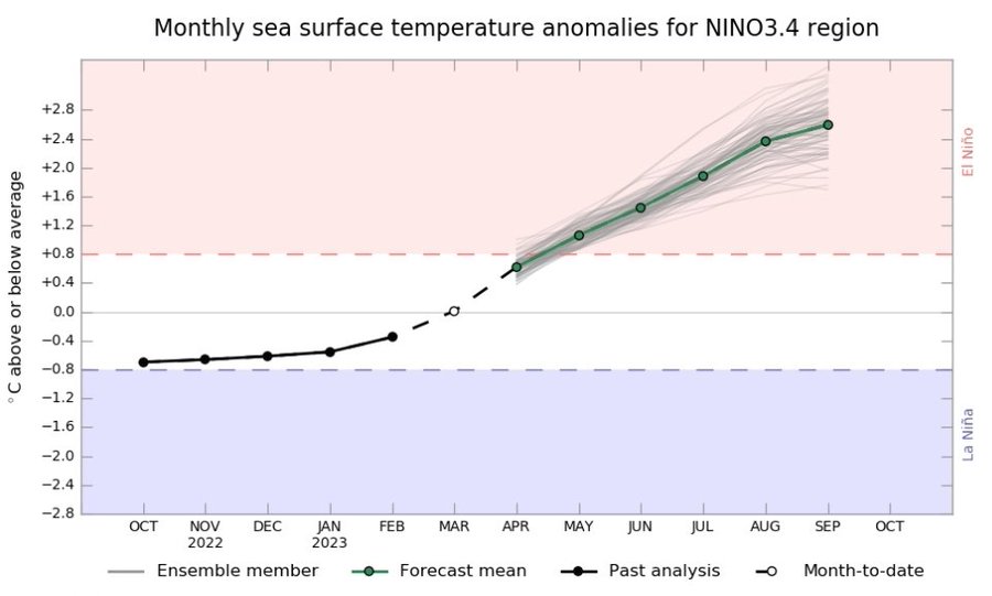
The may IRI update has even more spread than the April one did
-
Still thinking we get an early peaking strong east based (EP) nino, but not super? I’m skeptical of a strong solution but it is looking more likely than it did a couple weeks ago. The 3 and 3.4 regions warming up is a positive sign for El Niño development.
-
If the ONI is over 2.0 I’m going to set my expectations for another ratter and start looking to the 2024-2025 winter.
-
I get the argument for an east pacific (EP) event, but for strength the PDO being strongly negative is a red flag that I don’t think should be ignored. If it were a weakly negative PDO that would be one thing, but this is an extreme PDO event. How many strong ninos historically have developed alongside a -PDO of this magnitude? The -PDO is as negative as it was in 2010-2011, which was a strong Nina. I do think we get a nino, but I’m skeptical of the stronger outcomes. Weak ninos and moderate ninos developing alongside -PDOs are more common.
-
The latest IRI Enso forecast still has a wide range of outcomes with 2 camps. One camp is clustered around a low end strong peak, the other is forecasting a weak nino peak. The moderate to strong camp is bigger than the weak camp, and a uper nino and no nino at all are extreme outliers. If the models are correct it looks like this El Niño is for real, but it’s not going to be anywhere near historic in strength. Moderate to strong? Sure, there is plenty of model support for that outcome. Super? Nope, there is more model support for a weak nino than a super nino.
-
I disagree that PDO is independent. While you are correct that it’s not always -PDO = Nina and +PDO = Nino, it does have an impact. It is possible that we get a strong or super nino and a -PDO like 1972-1973, but that is unusual (same with 1995-1996, +PDO and moderate La Niña). They are possible, but it’s best to hedge against unusual and or extreme outcomes until proven otherwise (Ive gotten burned by this quite a bit). If it was even a weakly (-1 or so) negative PDO the argument in favor of a big nino would be stronger, but it is a very strong -PDO and hasnt shown signs of increasing yet. The -PDO is why I’m leaning towards a moderate peak rather than strong or super. Due to the -PDO I’m also leaning towards an eastern pacific (EP) event, and a mild east coast winter for 2023-2024.
-
It’s definitely a realistic possibility, if it’s going to peak at strong we will start seeing signs soon, such as the PDO increasing rapidly.
-
Historically (coming off a big multi year Nina event) there is some support for a very strong nino to develop, but the latest obs aren’t all that impressive. Warmth mostly confined to enso 1.2 (which is by far the smallest zone in the enso region), subsurface fairly warm but nothing crazy (+ .9), and the -PDO. If anything, based on the latest obs I would think no El Niño at all is more likely than a super Nino. I’m starting to think it will peak at moderate, not strong.
-
BOS breaking 90 today? 82 degrees already.
-
Yeah, makes sense to lean warm until proven otherwise. The period now was depicted as a trough in the east on the long range guidance, yet it’s 81 degrees at 10am in mid April.
-
Not true, I installed a few days ago and looking at windows can see many others did the same. It’s April yeah, but it doesn’t feel like it. Its 88 degrees outside right now, feels like mid summer.
-
90s on Friday coming? Fridays forecast keeps increasing on my weather app.
-
What you are saying about the nino strength makes sense, but wouldnt it cause the PDO increase and become positive if the nino gets strong enough?
-
Yeah, looks like this El Niño will be quite powerful. Mean of roughly +1.6 ONI OND.
-
Yeah this is nice, way better than some years where it’s just 40 and drizzle the first half of spring. Next week is expected to be really nice too, 70s and even a couple of days in the 80s.
-
The guys I was thinking of were Joe Bastardi, Judah Cohen, and DT. They aren’t all from NE but they do forecast for the entire east coast, so I counted all of them. DT in particular went big, there was all this hype about how the Nina would weaken and we would get buried during the second half of the winter. Cohen wasn’t as bad, but his bias is still very much obvious. The Nina did weaken like DT said, but that didn’t really help. I don’t think I’ve ever seen a warm forecast from any of the guys I mentioned (which is a problem). The hype was off the charts in December. Regardless, ultimately it’s on me for buying in. One thing that you do that I wish more seasonal forecasters would do is you post the snowfall departure bias with every winter, and have statistics for a bunch of different cities since you started. I’d bet DT and JB would have something like a 75-100% positive bias for snowfall and are something like 5-6 degrees too cold. It would be nice to know this so people who are looking for a realistic forecast rather than hype know to avoid them, but that’s exactly why they don’t do that.
-
That makes sense, I remember in 2014-2015 the warm blob was pressed against the west coast, not way west like the Canadian has. As an New England snow weenie, Im not falling for the east coast big winter hype again until I see that western blob move east. It’s odd how quite a few New England based winter forecasters are allergic to forecasting warmth and rain in the east. Just telling snow lovers what we want to hear isn’t forecasting, it’s fantasy and that gets old after a while.
-
Btw Ray what’s your early thoughts on the strength of this nino based on the latest data? My gut instinct is it gets very strong, but not quite super nino. Something like +1.8 ONI, but it’s based off a surface level comparison of this year and similar years in the past.
-
Yeah, the Nina moving west killed us. I remember seeing your analog composite for modoki Ninas and they were really warm, correct me if I’m wrong but arent moderate-strong modoki Nina’s just as unfavorable as super ninos? If anything this winter was worse than 2015-2016, we had less snow for sure and I’m pretty sure this winter was warmer too. Locally it was a lot like 2011-2012. I know we don’t always see eye to eye but I’m with you on being excited about this upcoming El Niño event. Just gotta avoid the super nino and we have a shot at a decent winter. After the disaster that was the 2022-2023 “winter”, im just looking for winter to feel like winter, doesn’t need to be anything special.
-
That’s possible, but a lot of that warmth is already starting to surface. It could be wrong yeah but you don’t often see the models projecting a near +3 super nino. It may not be THAT strong, but i do think this is different than the 2012 head fake. The combination of model projections, us coming off a 3 year Nina, the MJO wave earlier in March, and the amount of warmth building in the enso 1.2 and 3 regions makes me think this El Niño is for real.
-
Yep nice and toasty, would be good for bass fishing.
-
Yeah that’s a big reason why Joe Bastardis winter forecasts have been getting worse and worse. He uses old analogs from when the base state was significantly cooler. As the base state continues to warm, those analogs become more and more cold biased.


