

TimB
-
Posts
17,229 -
Joined
Content Type
Profiles
Blogs
Forums
American Weather
Media Demo
Store
Gallery
Everything posted by TimB
-
 Hard to tell if this is just one of those years we never get the pattern or if it’s one of those years where we do get the pattern then end up with a 1/19/19 redux when we finally do.
 -
We can hope. Spice up this boring winter a little anyway.
-
Pretty spot on. An absolutely perfect day if it weren’t December 30th. 64 at PIT, 66 at AGC.
-
Ha. My bookmarks also include xmACIS and the 5 min obs, so I guess he and I are on the same page. But good idea, I should bookmark the site with all time second tier American soccer stats so I can discuss ad nauseam with my Hounds friends.
-
Lol. This is as Bubbler as it gets.
-
The last part of my post, the part about the ensembles is what I find most disconcerting. As has been mentioned here before, we don’t really need to be all that cold relative to normal in mid January to get a storm, but this is a pretty hostile pattern overall and that part doesn’t seem to be changing anytime soon.
-
0z models are all basically shutouts. GFS gets above freezing for afternoon highs all 16 days of its run. Euro doesn’t even really have a storm in the late next week time period. CMC pulls it too far west. 6z GFS has a workable solution where we get the fringes of a major mid Atlantic storm. At no point in any 0z ensemble run does our height anomaly get into the blue. Ensemble means for snowfall are pretty much as bad as they can get for a 16 day period in the heart of winter.
-
It’ll be interesting to see how high temps tomorrow can get. I could see it rivaling next Tuesday for the warmest day of this torch. Sunnier, too.
-
To a point, I agree. If it’s going to be warm and disgusting outside, which it is for at least the next week or so, give us as much of that warmth as possible. The record of 65 for Tuesday seems well within reach.
-
At the same time of day that it was -5 last Friday, it’s now 57.
-
It’s in line with the other models now, a rainy storm that tracks over or just west of our area.
-
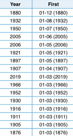
All years where the first freezing temperature of the new year was recorded on or after January 3rd. Will be interesting to see how far up this list we rise, but it looks like 2005 and 2006 were the only years since observations at the airport started that the first freeze of a calendar year occurred on or after the 4th.
-
A lot of shutouts or near-shutouts for a massive region of the country including us for the next 16 days on the GFS, this one from the 18z run being the most egregious. Euro’s last two runs are showing an almost workable solution with the system later next week after the heat wave, but it’s too warm on all the other models for anything but more rain.
-
A week and a half warm period with signs of life by the first full weekend of the new year would be acceptable. I think that’s pretty much in line with a lot of winters, we’ve been spoiled by two years with no real January torches that are actually pretty common in these parts. Sure, I would have wished the cold period would last more than a few days, but it was an epic cold snap that rivaled some of the greatest December arctic outbreaks ever recorded here. 2nd coldest Christmas Eve/Day period on record. And it probably was enough to clinch a below normal temperature December and, by my calculations, an ever so slightly below normal mean temperature for the entire year of 2022.
-
Hard to really say the warmup looks short. Ensemble height anomalies are red basically from Tuesday through the end of their runs. So that’s like two weeks of warmth if it stays that way.
-
We’re gaining about a degree per hour which should put us right around 12 or 13 by midnight.
-
NWS pretty much guarantees we set that record low max today, TWC suggests we’ll be very close to 13 by midnight. I guess we’ll see.
-
-6 was a rounded figure. Was -5 on the daily climate report. Still incredible. 1.2” of snow too.
-
-5 now at PIT.
-
HRRR won this one. Very little back end snow, mid single digits below by afternoon.
-
I don’t believe it was real snow falling. Probably just blowing snow that shows up that way on the automated obs.
-
Done. 12:30 obs was -4. With mod snow even.
-
No reason to believe it can’t. Wheeling is down to -4. PIT observed -1 on the hourly, then -2 right after so it’s officially our first below 0 in December since 1989 and only one degree to go to tie the daily record.
-
If we could somehow drop another few degrees and break today’s record low of -3, that’d make it interesting. But PIT has been stagnant at 0 for the last hour. Though I guess some of those could be -1’s because of the rounding thing.


