TimB
-
Posts
17,229 -
Joined
Content Type
Profiles
Blogs
Forums
American Weather
Media Demo
Store
Gallery
Everything posted by TimB
-
 HRRR is losing this one too. It’s over.
 -
Love when the 18z GFS does 18z GFS things. That fantasy storm that ushers in the brutal cold would make nearly everyone in the northeast and mid Atlantic happy.
-
Guess we’re putting all our eggs in the 18z HRRR basket at the very end of its range.
-
Euro is a parade of storms that we’re on the wrong side of. Not scoring on any of them might hurt.
-
Doesn’t look terrible. If only we could get it about 20 miles SE.
-
GEFS ensemble mean is ugly. A little over an inch at 10:1 before changeover, so probably less than an inch with the garbage ratios I’m expecting Wednesday.
-
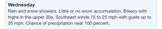
The verbiage in the previous forecast for Allegheny was “Snow accumulation possible.” Now it’s “Little or no snow accumulation.” Can’t be good.
-
Let’s hope the Canadians are wrong. Not liking anything the op or the RGEM or the ensemble are spitting out.
-
And ultimately I’d rather PIT not have recorded 2” or so today, as that adds an artificial amount to the record that the majority of people in Allegheny County didn’t see, which won’t reflect on paper how futile this winter has been in reality for most of us.
-
Get ready, the NAM shows warning level snow as close as Butler for Wednesday while areas near the city get like 2”.
-
It really wasn’t a big event, but taking route 8 from Mars south it went from 2” of wet, slushy snow to nothing by the time I got to about Hampton.
-
PIT will probably record a non-zero accumulation for today to pad the stats, judging from the obs for the past hour or two. Little comfort to those of us staring out the window at grass.
-
Oh for Christ’s sake. Edit: just kidding, that’s a 12 hour map. We still get a nice little 3 inch event on the front end.
-
NWS has revised the forecast event total for Pittsburgh to exactly 0” for today’s system.
-
This. This is all.
-
Summer is easier to appreciate after a real winter and when there isn’t a 75% chance it extends deep into October as recent climo would indicate.
-
Comical
-
But there’s still Wednesday to hold out what little hope we have for this week and winter. Lord knows the GFS solution where it’s cold next weekend after a little clipper is being tossed on sight in favor of the euro torch by anyone doing any degree of forecasting, and it’s shown it for like 7 runs in a row now.
-
GFS seems completely lost. It’s way out of phase with the Euro even a week out, and same goes for the ensembles. It’s been consistent with pushing an Arctic front through here about a week from now, and all other guidance seems to be warm for that period.
-
It’s not a bad snow to rain to snow setup. Ukie looks even better for what it’s worth. Drops warning level snow in 6 hours before the changeover. GEFS ensemble mean deteriorated from 18z tho. I’m ready to be hurt.
-
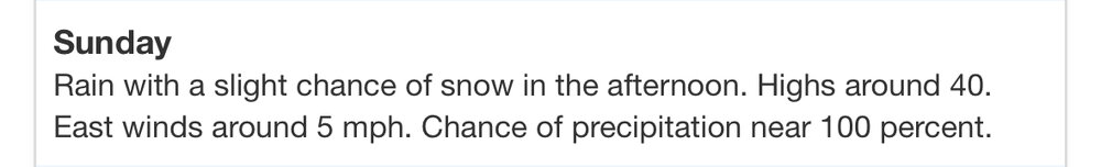
The 18z GFS is fantastic! A nice little borderline advisory level event Sunday and a nice thump of very heavy snow at daybreak Wednesday! What’s not to love! Better?
-
18z GFS doing 18z things. I don’t imagine anyone here would be unhappy if next week played out that way, but it’s probably a pipe dream.
-
Really starting to look like the window closes quickly again if the upcoming week fails us. Euro and EPS are already saying warm next weekend.
-
3k NAM is probably the ceiling for the Sunday event. Drops a clean 3” of all snow, but of course that’s still in the end of its range. NWS is carrying next to nothing and mostly rain. Is it over?
-
Euro is still holding onto a scenario where it isn’t complete garbage and we get decent snow on the front end, but we all know the warm air always comes in way faster than modeled.