

TimB
-
Posts
17,229 -
Joined
Content Type
Profiles
Blogs
Forums
American Weather
Media Demo
Store
Gallery
Everything posted by TimB
-

Pittsburgh/Western PA Spring 2023 Discussion
TimB replied to Ahoff's topic in Upstate New York/Pennsylvania
February is a short month, so spring is only 34 days away. And our snow total is 11.4” but probably a majority of the county has received less than half that. -
Pittsburgh/Western PA Spring 2023 Discussion
TimB replied to Ahoff's topic in Upstate New York/Pennsylvania
If by astronomical winter you mean astronomical(ly bad) then I agree. -
I’ll believe it when it goes away for more than 4 days.
-
Someone has to play the KPIT role. But yeah, I have no idea why this storm that we knew was going to be a fail pushed me over the edge.
-
Even when it’s over we’ll still have a permanent southeast ridge. That feature is set in stone for decades.
-
Once one model shows bad it’s over. Every. Single. Time.
-
Well I mean that’s the ensemble, not the long range operational model.
-
18z GFS proves the 12z wasn’t just a one off and still has us locked in an endless torch hellscape with cutter after cutter instead of what is supposed to be a cold pattern. Ensemble is on board too. Next Saturday now has positive height anomalies here. Unbelievable.
-
A quick calculation seems to indicate that we should finish January about +8 on temps and be in the running with 1998 for 2nd warmest January since official obs moved to the airport. Don’t think we can catch 2006.
-
The snow futility record for Pittsburgh is 8.8” in 1918-19, so we’re out of the running for that. What we do still have a shot at is the modern snow futility record of 16.6” in 1973-74 if you don’t trust the records from over a century ago. There’s also the 17.2” in 1990-91, 21.7” in 1988-89, and 22.4” in 2019-20 to round out the list of worst winters in modern history.
-
Sunday-Monday put PIT up to 10.3” so officially no, but I’m sure there are plenty of places in the county that are below 10” or maybe even below 5”. Looks like the NWS obs for today is going to be 1.1”, so we’d be at 11.4 officially.
-
Big picture, that’s a good way of looking at it. This has probably been the most frustrating winter of the 21st century, and that includes 19-20.
-
Meh, too little too late unless it’s the 2-3” today should have been. Anything less than 2”, even 1.9”, tomorrow and this event is still an epic failure to me. Oh, and NWS suggests it could STILL, ON THE BACK END OF THE SYSTEM be warm enough for rain to mix in tomorrow afternoon.
-
Once the permanent southeast ridge returns on Saturday, it remains over our area in some way, shape or form for the remainder of the 12z GFS run.
-
This winter is over, not that it ever started. Today was our last chance. Unless I see something that proves otherwise, the southeast ridge is a permanent fixture of our climo now and will be for years and decades to come.
-
Anyone remember when the first weekend of Feb was supposed to be the cold part of our pattern? This failure of a winter rolls on.
-
Yeah, I shouldn’t be mad. This turned out exactly how everyone but the NWS expected it would, and exactly according to our climo. On to the next disappointment.
-
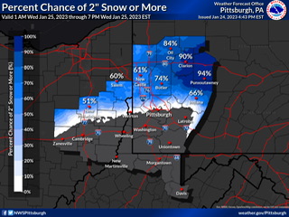
It could be successfully argued that they knew as soon as last night that there was a 0% chance of 2” for the majority of the county, including the part most people commute to, as evidenced by the probabilistic map they themselves posted to social media. They have other products like the special weather statement for a quick inch that impacts the morning/evening rush.
-
Remember, this thing got an advisory and still has an active advisory in our county.
-
It matters in a “the NWS will never admit they were wrong” kind of way.
-
The way I understand it, if at least 50% of Allegheny County doesn’t get 3” or more, then issuing and keeping the advisory was a bust.
-
Absolutely hilarious that we’re still under an advisory.
-
Pretty hard to justify keeping Allegheny county in the advisory with a 59% chance of getting even 1” and virtually no chance at getting 2” for most of the county.
-
They upped the totals for the KPITsnow MLK Day dry slot/mixfest of 2022 at the last minute when all the models were going the other direction and it worked out, right?
-
18z HRRR looks dry as hell.
