TimB
-
Posts
17,229 -
Joined
Content Type
Profiles
Blogs
Forums
American Weather
Media Demo
Store
Gallery
Everything posted by TimB
-
How goddamn cruel is this world that this had to happen almost exactly 50 years after that moment?
-
Does it have to be? No. Just like when you have a winter storm watch and they disappointingly turn it into a winter weather advisory.
-
 CTP hoisted a wind chill watch this afternoon so I anticipate PBZ could possibly do the same for continuity.
 -
NWS will give us a wind chill advisory. I give that a 99% chance. Wind chill is progged to be below the -10 threshold for like 24 hours straight at PIT.
-
Looks like the NWS got their excuse not to put up Friday snowfall maps yet, with the small amount of front end ice in the higher elevations tomorrow being the threat their maps address. Typical.
-
The other shoe has finally dropped. GFS is coming in line with other models on our lack of snow potential. Ceiling can’t be more than an inch and a half.
-
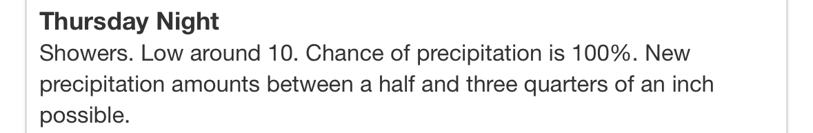
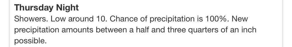
Fact of the matter is we’ll be down to 10 at some point Friday morning, regardless of semantics.
-
TWC isn’t any better.
-
More importantly, NWS seems to be rolling with 1-1.5”.
-
Enjoyed this way too much. Point and click for PIT.
-
I feel like the Kuchera’s going to overestimate us on this one. No way we’re getting the kind of ratios that an air temp in the single digits would imply in that calculation.
-
Would you define something like .7” as getting blanked?
-
Alarmingly, a solid half of them are this century. It’s about a 25% chance these days, it appears.
-
Wouldn’t be surprised if the NWS issued an advisory if they end up agreeing with the 1-3”, given the additional impacts and the fact that it’s happening on a busy travel day.
-
I think they use a 72 hour rule so we may have their first forecast later today.
-
The weather fanatic in me says there’s plenty to watch here, even if we don’t get much if any snow. I’m coming around to the idea that this is going to be a fun little blast of winter no matter how much or little white stuff we get.
-
Is jwilson an actual met or is he just smart? Or did he stay at a Holiday Inn Express last night?
-
Probably too early to take any NAM output seriously.
-
I know it’s the NAM at range, but the first look at the back end snow potential on the NAM is, well… not good.
-
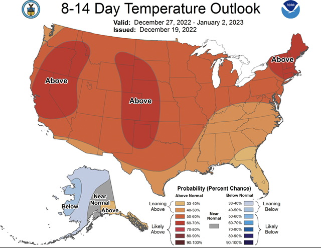
Part of Florida was red or at the very least grey, so not quite the same. This is literally 100% coverage of red, and it happens alarmingly often.
-
Guess what’s back yet again. Entire CONUS above normal, as seems to happen at least 5 times a year these days. The opposite never happens.
-
Ensembles are virtually unchanged for snow from 0z. Maybe an inch, two if we’re lucky on the ground for Christmas. The biggest change is that all of them bring the Arctic front through on Friday morning rather than later in the day.
-
SW flow behind the front. Forget it.
-
Once the 500 anomalies on the GEFS go red over our area next Tuesday, they stay red for the remainder of the run.
-
Continues to crush our back end snow dreams. You know that’s how it’s going to play out too.