TimB
-
Posts
17,229 -
Joined
Content Type
Profiles
Blogs
Forums
American Weather
Media Demo
Store
Gallery
Everything posted by TimB
-

Fall 2022 Pittsburgh/Western PA Discussion
TimB replied to Ahoff's topic in Upstate New York/Pennsylvania
Thanks for the clarification. So that would make this the 9th time in 71 years at PIT that the first freeze hasn’t occurred by the end of October and first time it’s ever happened in back to back years at PIT. -
Fall 2022 Pittsburgh/Western PA Discussion
TimB replied to Ahoff's topic in Upstate New York/Pennsylvania
Latest first freezes at PIT since the airport became the official site. Seems likely we crack the top 5 at this point, as a freeze is unlikely in the next 10 days.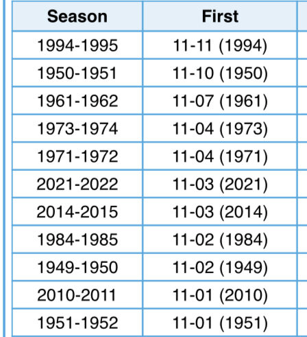
-
Fall 2022 Pittsburgh/Western PA Discussion
TimB replied to Ahoff's topic in Upstate New York/Pennsylvania
Yeah, it’d be nearly impossible to get to normal or above at this point. Second half of the week looks sufficiently close to normal to secure a BN month. On a related note, looks like today’s high was 73 so that record cold max for October is no longer in play. -
Fall 2022 Pittsburgh/Western PA Discussion
TimB replied to Ahoff's topic in Upstate New York/Pennsylvania
Pretty impressive radiational cooling outside of the UHI last night. Was remarking to my wife how quick it got cold as soon as the sun went down and it looks like a lot of the area achieved mid 30s (36 at PIT). For contrast, AGC only got to the mid 40s. -
Fall 2022 Pittsburgh/Western PA Discussion
TimB replied to Ahoff's topic in Upstate New York/Pennsylvania
If the remainder of the month overperforms, might not be a BN month. Current forecast would put us at about -1 for the month. -
Fall 2022 Pittsburgh/Western PA Discussion
TimB replied to Ahoff's topic in Upstate New York/Pennsylvania
The wind was probably the ingredient that screwed us out of a freeze, was 5-8mph out of the SSW pretty much all night. -
Fall 2022 Pittsburgh/Western PA Discussion
TimB replied to Ahoff's topic in Upstate New York/Pennsylvania
Looks like PIT is going to bottom out at 33. With the incoming warmer stretch, it’s now very possible that we go a second straight October without a freeze. The last time that happened in consecutive years was 1949-1951. -
Fall 2022 Pittsburgh/Western PA Discussion
TimB replied to Ahoff's topic in Upstate New York/Pennsylvania
True. If it were January, the NWS would continue to roll with an all snow forecast while rain and sleet were falling outside our windows. -
Fall 2022 Pittsburgh/Western PA Discussion
TimB replied to Ahoff's topic in Upstate New York/Pennsylvania
NWS has adjusted overnight p-type to rain for many of us. We’re in midseason form. -
Fall 2022 Pittsburgh/Western PA Discussion
TimB replied to Ahoff's topic in Upstate New York/Pennsylvania
-
Fall 2022 Pittsburgh/Western PA Discussion
TimB replied to Ahoff's topic in Upstate New York/Pennsylvania
In some Deep South locations, it’s close to the earliest instances on record of certain temperature thresholds. The exact wording of the warnings for portions of Mississippi and Alabama mention temperatures as low as 24. -
Fall 2022 Pittsburgh/Western PA Discussion
TimB replied to Ahoff's topic in Upstate New York/Pennsylvania
Verbatim, that does show measurable snow at PIT. I don’t see it happening, but even a tenth this early would be an extremely rare first measurable snowfall (10/18/1972 and 10/18-19/1992). -
Fall 2022 Pittsburgh/Western PA Discussion
TimB replied to Ahoff's topic in Upstate New York/Pennsylvania
Interesting, gives me deja vu. I think we almost set such a record in April 2020, only to have the second to last day of the month get too warm. But obviously the thing we have going for us in October that we don’t in April is that you’re not “supposed” to see the warmest temperatures late in the month. -
Fall 2022 Pittsburgh/Western PA Discussion
TimB replied to Ahoff's topic in Upstate New York/Pennsylvania
Yeah, any model output showing measurable snow next week should probably be tossed. -
Fall 2022 Pittsburgh/Western PA Discussion
TimB replied to Ahoff's topic in Upstate New York/Pennsylvania
And that’s actually the 3rd best of the 0z models for snow in our area, lol. -
Fall 2022 Pittsburgh/Western PA Discussion
TimB replied to Ahoff's topic in Upstate New York/Pennsylvania
Think that gusty downpour this morning was the fropa. Looks like it was between 8:20 and 8:30 at PIT, so a little after that for most of us.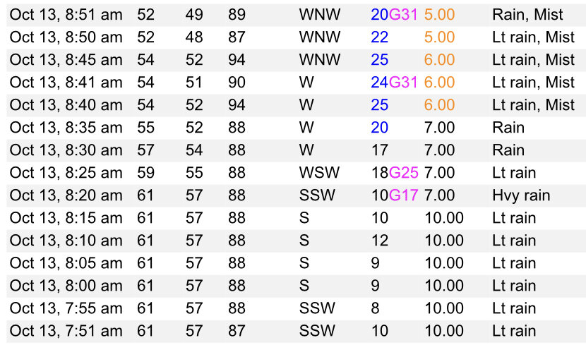
-
Fall 2022 Pittsburgh/Western PA Discussion
TimB replied to Ahoff's topic in Upstate New York/Pennsylvania
Probably not until a model run shows something like this?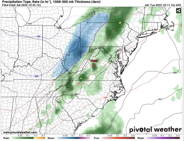
-
Fall 2022 Pittsburgh/Western PA Discussion
TimB replied to Ahoff's topic in Upstate New York/Pennsylvania
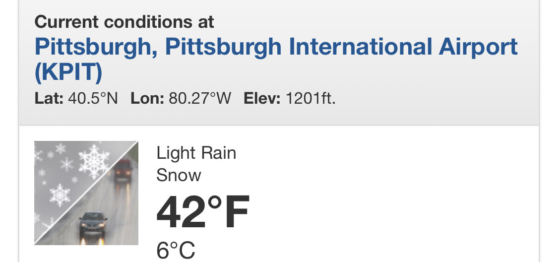
It appears a certain icon has appeared in my weather app.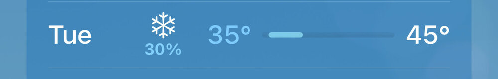
-
Fall 2022 Pittsburgh/Western PA Discussion
TimB replied to Ahoff's topic in Upstate New York/Pennsylvania
Looks like our streak of below normal days finally ends at 15. Longest since Feb 2021. -
I’ll forgive you for bringing this weather if you don’t also bring us a loss or tie against the Jets. Lol.
-
Fall 2022 Pittsburgh/Western PA Discussion
TimB replied to Ahoff's topic in Upstate New York/Pennsylvania
Yeah, Ian looks to track far enough this way to make for a rainy weekend. Looks like my Saturday evening will be more heavily affected than your Sunday afternoon at this juncture, but won’t stop me from hanging out in the rain for a couple hours. -
Fall 2022 Pittsburgh/Western PA Discussion
TimB replied to Ahoff's topic in Upstate New York/Pennsylvania
That’s the plan. This your annual Steelers trip? -
Fall 2022 Pittsburgh/Western PA Discussion
TimB replied to Ahoff's topic in Upstate New York/Pennsylvania
I think we’re actually slightly BN for the YTD. -
Fall 2022 Pittsburgh/Western PA Discussion
TimB replied to Ahoff's topic in Upstate New York/Pennsylvania
Looks like today’s high of 59 will be the first September day since 2014 that did not get to 60. -
Fall 2022 Pittsburgh/Western PA Discussion
TimB replied to Ahoff's topic in Upstate New York/Pennsylvania
Still have a shot at a slightly below normal September with the upcoming forecast.