

TimB
-
Posts
17,229 -
Joined
Content Type
Profiles
Blogs
Forums
American Weather
Media Demo
Store
Gallery
Everything posted by TimB
-
 Outside of Buffalo and a few locations in Maine, everyone in the east is nowhere even close to normal snowfall. Pathetic.
 -
I take that back. Today got to 60 just after midnight.
-
I think we’re in 7th for the YTD period for mean temp. 1990 is the only year currently ahead of us from the airport.
-
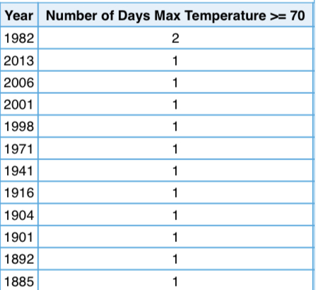
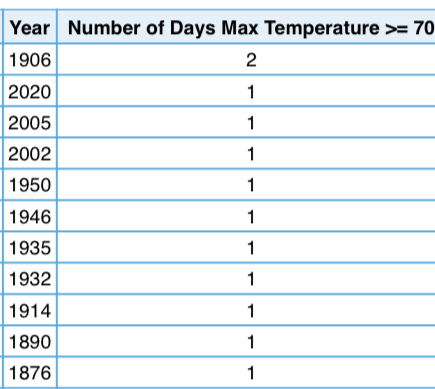
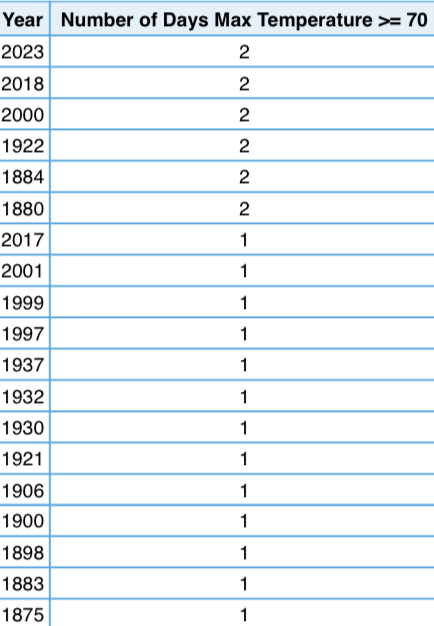
Since a lot of the discussion to this point was related to 70s in February, that’s probably the more salient point here. After a period of 60 years where it didn’t occur even once, we’ve had 10 since 1997, and half of those have been since 2017.
-
I’ll agree with you here. More unusual was probably the lack of many such days in Jan-Feb 2021-2022. A 60 degree day in February really is relatively normal, and technically we’ve only had two this February so far (it just so happens that both of them were in the 70s).
-
I’m not entirely certain he’s denying it, but rather (correctly) pointing out that this garbage winter can’t be completely 100% attributed to it. The patterns are pretty stark, but the last two winters were fine.
-
Not in a single month it didn’t.
-
December: January: February: Euro for 2/23: CMC for 2/23: No winter month has ever gotten to 70 degrees three times. It’s looking possible.
-
Yeah, you’re right, everything we’ve had so far is precedented in some way, whether it’s with really old data or I’m cherry picking stats. But the models are converging on a solution within a week that would give us an unprecedented, not that obscure stat. Hint: We tied a record yesterday that we very well might have the opportunity to break next week. Something that’s quite literally never happened in any winter month ever.
-
And just like that, next week’s hope is gone. The last week of meteorological winter, at that. Truly more abysmal than 2019-20, and I was hoping that wasn’t possible.
-
70 has been attained. 3rd time in history that this has happened twice by 2/15.
-
Yeah, downtown was at an elevation of 1200 feet in the 1800s.
-
Yeah, probably like 4 feet from the exhaust of a steel mill or something.
-
Also, there are only two times on record that February has recorded an inch or less of snow in Pittsburgh, 1909 with 0.5” and 1884 with 0.6”. We’re at 0.2” so far and if the 12z GFS is right, we have a chance at breaking those records.
-
Careful, they don’t want you to talk about that in the regional subforums.
-
I’ve seen enough with the 12z model runs. GFS sends a cutter way out into the Midwest next week with absolutely zero snow here, and the CMC puts one storm north of us and another south of us. It’s over, yet again. How many ways can this winter screw us?
-
This is pretty clearly visible on the 0z model runs. We just aren’t going to get a win this winter.
-
Pittsburgh/Western PA Spring 2023 Discussion
TimB replied to Ahoff's topic in Upstate New York/Pennsylvania
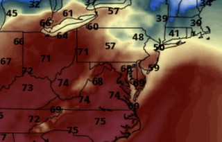
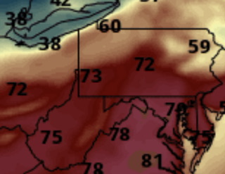
I don’t see how you can rule out mid 70s when it’s already 57 and full sun expected all day. HRRR was 5 degrees too cold at 7am and tops us out at 71. But NWS just updated their point and click and hacked about 5 degrees off the highs and says about 67. -
Looks like 70 degrees is indeed attainable tomorrow. The only year so far where 70 has been reached from two distinct events on or before 2/15 is 1932. There were also 2 days that got to 70 early in 1906, but they were consecutive and so part of the same event. Snow chances next week or more disappointment? I guess we’ll see.
-
I guess in that sense, we made some gains last year and the year before so this garbage winter won’t put us too far below the pace.
-
You mean I can’t worry about winters getting less snowy and the train derailment and the Chinese balloons and whether or not Rihanna’s halftime show was suitable for my 4 year old nephew at the same time? Damn.
-
Yeah, I’ll admit it’d be nothing like replacing a 72.1” (92-93) with a potentially sub-20 inch 22-23.
-
If next year is a 70” year, the averages will continue to drop because it’ll eventually replace 93-94, which had 76.8”, in the climate normals.
-
Just wait until the next 30 year averages, once 92-93 is replaced with 22-23.
-
People who were born in 1937 didn’t know what a 70 degree Feb day was until they were 60 because they didn’t exist in that timeframe. But we know, because they happen every few years now.


