

TimB
-
Posts
17,229 -
Joined
Content Type
Profiles
Blogs
Forums
American Weather
Media Demo
Store
Gallery
Everything posted by TimB
-
The “they” I was referring to was people like Chesco. Climate denial is not rooted in grounded facts, it’s rooted in appeals to emotion like “but my kids.”
-
Why do they always play the “children” card when they’re losing?
-
 That’s essentially what I’m saying. Worst in over 90 years is notable enough. We each can decide on our own if we trust the old records. It might not be indicative of any long term trend in snow totals, let’s hope not anyway, but it’s honestly surreal to go through a winter like this. It plays with your perception of time. It doesn’t feel like March because we haven’t had winter yet. It doesn’t feel like we’ll be turning the clocks forward tomorrow night. It doesn’t feel like the next major snowfall is at least 9-10 months away. I’m never a big fan of the flip from winter to spring, but it doesn’t even feel real this year.
 -
I guess it’s really not even a point worth debating, it’s the difference between a terrible winter (one of the worst on record) or literally the worst one on record. I’m still hoping, though that hope is starting to fade, that we get something, anything, out of this pattern we’re in now to render this debate moot.
-
I acknowledged that in my post. Judging by the area by the airport, snow totals were about 60% higher than this map shows. So the 5” is really more like 8”.
-
So there you have it. The estimate for the airport looks a little low, but this is saying the city has gotten a little over half what the airport has, so even if you scale the airport up from ~9” to the actual amount of 14.5” (an increase of about 60%), that scales the city up to about 8”. Which would make this the worst snow season on record, worse than the 8.8” in 1918-19.
-
The differences are pretty stark when you look at prolific winters like 1950-51 (yes, I know this one was pre-KPIT) 1960-61, 1969-70 and 1977-78. You’re talking 25” of difference in some of those.
-
Could you make the argument that Pittsburgh (in the city) has seen less than 8.8” this winter? I think it’s possible.
-
I wouldn’t be, but I’d like to not set a snow futility record. So I either have to hope for a few more inches of snow or pretend the 8.8” from 1918-19 is legit.
-
For those keeping score, we need 2.1 more inches of snow to avoid setting the KPIT record and what is likely the real record for least snow in a season, the 16.6” in 1974.
-
It is indeed weird. I didn’t live here during that storm, so I have zero anecdotal evidence of anything that did or didn’t happen, but something’s odd.
-
Yeah I really think the 11th is dead. So now anyone who’s still holding onto any chance of anything resembling winter before the interminable 9 months to follow will just have to hope for something the following week under ever more hostile climo. Every week that passes from here on out, it gets exponentially more difficult to get meaningful snowfall. It’s honestly surreal to think we’re on the cusp of making it through an entire winter without anything slightly resembling winter other than those 3 days at Christmas. To illustrate this, there are exactly 9 warning level (6” or more) snowstorms in our records beyond 3/15, and only two in the past 65 years. It would be a miracle if something pans out in the 3/15-3/17 timeframe that some are touting.
-
We desperately need next weekend to not turn into the clusterf*** that the Euro showed, if only to take the focus off of this NWS Ike coverup.
-
It’s Friday afternoon. Please, for the sake of your weekend, no one look at the 12z Euro. You’ll thank me later.
-
And it’s official. 70 again. Earliest in a calendar year we’ve gotten there 4 times. Previous record was March 6th in 1946.
-
I think this table is wrong. The 59.8 belongs to 17-18, not 18-19, which I think was slightly below normal. The ones below it should be shifted down as well.
-
Yeah I was just joking. I rather enjoyed last summer to be honest. I haven’t forgotten that we managed an ever so slightly below normal 2022 if you look at the entire year. We had to pay for it at some point, and pay for it we did.
-
2022, the year without a summer, where all three months were chilly and we didn’t get to 94 in June. In unrelated news, I really hope this mid-March setup produces for us. It looks like a decent signal for a chance at some goods to close out the season.
-
I deliberately excluded months that came before the super Niño permanently ushered in new levels of heat.
-
I’d get raked over the coals for saying something like the bolded, as it really is just one year and Jan-Feb was fine last year and the year before, but then I remember all of the horrific, hellish winter months we’ve had in the last 8 years. December 2015, January 2017, February 2017, February 2018, January 2020, December 2021, January 2023, February 2023. That’s an average of one winter month every year that is so far above normal that it’s remarkable. There is not a single month in that period with as negative a departure as any of the above months are positive.
-
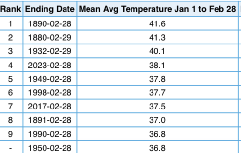
And so today concludes the warmest Jan-Feb period anyone who posts here has ever experienced in this area. Warmer than 2017. Warmer than 1998.
-
Missing out on a snowstorm in December or January, you know there will probably be more chances. Missing out on a snowstorm as the calendar flips to spring stings a lot more knowing it may very well be the last chance for a very long time. Especially in a winter where there hasn’t been a single period other than 72 hours around Christmas that even slightly resembled winter.
-
The usual “always a bridesmaid” that our area does best when it comes to most types of weather. Pittsburgh is right at the fringe of the marginal risk. Can’t see how we’re going to achieve much instability as dreary as it is out there.
-
What if it’s not? What if this is what winter is now?
-
In a matter of like 2 days, we went from something well south of us to something where the heaviest snowfall might be west of the Mississippi. You can’t make this shit up.


